Zengcheng District
Zengcheng
增城区 Tsengshing | |
|---|---|
District | |
 Gualü Square in Licheng Subdistrict | |
 | |
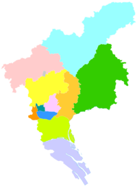 Zengcheng in Guangzhou | |
| Country | People's Republic of China |
| Province | Guangdong |
| Sub-provincial city | Guangzhou |
| Area | |
| • Total | 1,741.4 km2 (672.4 sq mi) |
| Population (2006) | |
| • Total | 810,554 |
| • Density | 470/km2 (1,200/sq mi) |
| Time zone | UTC+8 (China Standard) |
| Postal code | 511300 |
| Area code(s) | 020 |
| Website | http://www.zengcheng.gov.cn/ |
| Zengcheng | |||||||||||||||
|---|---|---|---|---|---|---|---|---|---|---|---|---|---|---|---|
| Chinese | 增城 | ||||||||||||||
| Guangdong Romanization | Zeng1-xing4 | ||||||||||||||
| Hanyu Pinyin | Zēngchéng | ||||||||||||||
| Postal | Tsengshing | ||||||||||||||
| Literal meaning | Expanding City | ||||||||||||||
| |||||||||||||||
Zengcheng District (alternately romanized as Tsengshing)[a] is one of 11 urban districts of the prefecture-level city of Guangzhou, the capital of Guangdong Province, China.
History[]
Zengcheng County was established under the Qin following their conquest of the area, formerly held by the Baiyue tribes. Under the Ming, the northern area of the county was separated to form Longmen County, administered from Huizhou. The county was promoted to city status in 1993. In 2006, a western section of Zengcheng was severed to form Guangzhou's Luogang District, which was renamed Huangpu in 2014. On 12 February of the same year, Zengcheng was annexed to Guangzhou as a district.[2] A riot of migrant workers occurred in Zengcheng in 2011.
Notable people:
- Zhan,ruo shui( 湛若水): philosopher of Ming dynasty
- Yeung,sum ( 楊森):Hong Kong politician
Climate[]
Zengcheng's mild climate, fertile land, annual average temperature of 22.02 degrees and average yearly rainfall of 1,967 millimetres (77.4 in) make it suitable for tropical and subtropical crop growth. The district is noted for production of the lychee.
| Climate data for Zengcheng (1981−2010) | |||||||||||||
|---|---|---|---|---|---|---|---|---|---|---|---|---|---|
| Month | Jan | Feb | Mar | Apr | May | Jun | Jul | Aug | Sep | Oct | Nov | Dec | Year |
| Record high °C (°F) | 27.4 (81.3) |
28.7 (83.7) |
33.1 (91.6) |
33.7 (92.7) |
35.3 (95.5) |
37.0 (98.6) |
37.7 (99.9) |
37.4 (99.3) |
37.8 (100.0) |
36.1 (97.0) |
33.2 (91.8) |
30.6 (87.1) |
37.8 (100.0) |
| Average high °C (°F) | 18.9 (66.0) |
19.2 (66.6) |
22.3 (72.1) |
26.3 (79.3) |
29.4 (84.9) |
31.7 (89.1) |
33.0 (91.4) |
32.9 (91.2) |
31.7 (89.1) |
29.3 (84.7) |
25.7 (78.3) |
21.5 (70.7) |
26.8 (80.3) |
| Daily mean °C (°F) | 13.9 (57.0) |
14.8 (58.6) |
18.3 (64.9) |
22.4 (72.3) |
25.3 (77.5) |
27.5 (81.5) |
28.3 (82.9) |
28.2 (82.8) |
26.6 (79.9) |
23.6 (74.5) |
19.5 (67.1) |
15.8 (60.4) |
22.0 (71.6) |
| Average low °C (°F) | 10.6 (51.1) |
11.6 (52.9) |
15.2 (59.4) |
19.5 (67.1) |
22.2 (72.0) |
24.6 (76.3) |
25.1 (77.2) |
25.1 (77.2) |
23.3 (73.9) |
19.8 (67.6) |
15.5 (59.9) |
12.0 (53.6) |
18.7 (65.7) |
| Record low °C (°F) | 0.7 (33.3) |
3.0 (37.4) |
6.2 (43.2) |
9.2 (48.6) |
15.4 (59.7) |
17.9 (64.2) |
19.6 (67.3) |
21.7 (71.1) |
15.7 (60.3) |
8.6 (47.5) |
5.7 (42.3) |
0.0 (32.0) |
0.0 (32.0) |
| Average precipitation mm (inches) | 41.3 (1.63) |
71.0 (2.80) |
113.6 (4.47) |
229.6 (9.04) |
315.2 (12.41) |
371.3 (14.62) |
278.8 (10.98) |
255.6 (10.06) |
170.1 (6.70) |
52.9 (2.08) |
36.9 (1.45) |
30.4 (1.20) |
1,966.7 (77.44) |
| Average relative humidity (%) | 73 | 77 | 82 | 83 | 83 | 84 | 83 | 83 | 81 | 75 | 70 | 69 | 79 |
| Source: China Meteorological Data Service Center | |||||||||||||
Administrative divisions[]
There are currently 6 subdistricts and 7 towns.
On 28 August 2012 one new subdistrict (Yongning) and one new town () were established from carving out of Xintang.[3]
| Name | Chinese (S) | Hanyu Pinyin | Canton Romanization | Population (2010)[4] | Area (km2) |
|---|---|---|---|---|---|
| 荔城街道 | Lìchéng Jiēdào | lei6 séng4 gai1 dou6 | 191,777 | 132.27 | |
| 荔湖街道 | Lìhú Jiēdào | lei6 wu4 gai1 dou6 | |||
| 增江街道 | Zēngjiāng Jiēdào | zeng1 gong1 gai1 dou6 | 78,072 | 86.18 | |
| 朱村街道 | Zhūcūn Jiēdào | ju1 qun1 gai1 dou6 | 43,557 | 93.90 | |
| Yongning Subdistrict | 永宁街道 | Yǒngníng Jiēdào | wing5 ning4 gai1 dou6 | 391,287 | 104.14 |
| 宁西街道 | Níngxī Jiēdào | ning4 ség6 gai1 dou6 | |||
| town | 新塘镇 | Xīntáng Zhèn | sen1 tong4 zen3 | 85.09 | |
| town | 仙村镇 | Xiāncūn Zhèn | xin1 qun1 zen3 | 56.65 | |
| town | 正果镇 | Zhèngguǒ Zhèn | zéng3 guo2 zen3 | 40,387 | 236.40 |
| town | 石滩镇 | Shítān Zhèn | ség6 tan1 zen3 | 121,674 | 184.00 |
| town | 中新镇 | Zhōngxīn Zhèn | zung1 sen1 zen3 | 78,293 | 236.00 |
| town | 派潭镇 | Pàitán Zhèn | pai3 tam4 zen3 | 58,337 | 289.50 |
| town | 小楼镇 | Xiǎolóu Zhèn | xiu2 leo4 zen3 | 33,725 | 136.00 |
Tourist attractions[]
opened to public in December 2014. The resort has a total area of 163 acres, and it consists of two theme parks, East Village and West Village. Located in the heart of Erlongshan subtropical rainforest, Twin Dragon Resort is blessed with exceptional natural resources and marvelous landscapes. To experience traditional Chinese culture, Twin Dragon Resort also offers a variety of family activities and events, suitable for visitors of all ages to participate.
Demography[]
Owing to the distance from Guangzhou's city center, many locals consider themselves distinct from the other Guangzhounese. They also speak separate Yue and Hakka dialects.[5]
Education[]
Colleges[]
- Guangdong University of Technology Huali College
- Guangzhou University Songtian College
- Guangdong University of Finance & Economics Huashang College
- Guangzhou Kangda Vocational Technical College
International schools[]
Notes[]
References[]
- ^ Baynes, T. S., ed. (1878), , Encyclopædia Britannica, 5 (9th ed.), New York: Charles Scribner's Sons
- ^ 黄埔萝岗合二为一 增城从化撤市改区 [Huangpu and Luogang Districts merge, Zengcheng becomes a District] (in Chinese). 南都网. Retrieved 13 February 2014.
- ^ "2012年度区划概况复". Guangdong Province Census Network. Guangdong Provincial Government. Retrieved 11 April 2018.
- ^ shi, Guo wu yuan ren kou pu cha ban gong; council, Guo jia tong ji ju ren kou he jiu ye tong ji si bian = Tabulation on the 2010 population census of the people's republic of China by township / compiled by Population census office under the state; population, Department of; statistics, employment statistics national bureau of (2012). Zhongguo 2010 nian ren kou pu cha fen xiang, zhen, jie dao zi liao (Di 1 ban. ed.). Beijing Shi: Zhongguo tong ji chu ban she. ISBN 978-7-5037-6660-2.
- ^ The official history record of Zengcheng 增城县志
- ^ "Contact." Utahloy International School Zengcheng. Retrieved on September 28, 2015. "Address: Guangshan Highway, Sanjiang Town, Zengcheng Guangdong, PRC 511325 增城誉德莱国际学校 - 中国广东省广州市增城市广汕公路三江镇" - See map in the last page of the "UISZ School Booklet."
External links[]
Guangzhou | ||
|---|---|---|
| Administrative divisions |    | |
| Attractions |
| |
| Culture & demographics |
| |
| Higher Education |
| |
| History |
| |
| Sports venues |
| |
| Transport |
| |
Guangzhou (capital) | |||||||||||||||||||||||||||||||||||||||||||||||||||||||||||||||||||||
| Sub-provincial cities |
| ||||||||||||||||||||||||||||||||||||||||||||||||||||||||||||||||||||
| Prefecture-level cities |
| ||||||||||||||||||||||||||||||||||||||||||||||||||||||||||||||||||||
| |||||||||||||||||||||||||||||||||||||||||||||||||||||||||||||||||||||
Pearl River Delta Metropolitan Region (Guangdong-Hong Kong-Macau Greater Bay Area) | ||
|---|---|---|
Pearl River Delta Economic Zone | ||
| Guangdong Province |  | |
| Special administrative regions |
| |
Coordinates: 23°17′17″N 113°49′41″E / 23.28806°N 113.82806°E

- Zengcheng District