Fengshan County
Fengshan County
凤山县 | |
|---|---|
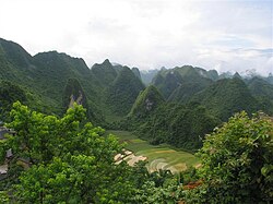 Peak-cluster depressions | |
 Fengshan Location in Guangxi | |
| Coordinates: 24°33′N 107°03′E / 24.550°N 107.050°ECoordinates: 24°33′N 107°03′E / 24.550°N 107.050°E | |
| Country | People's Republic of China |
| Region | Guangxi |
| Prefecture-level city | Hechi |
| County seat | Fengcheng (凤城镇) |
| Area | |
| • Total | 1,743 km2 (673 sq mi) |
| Elevation | 484 m (1,588 ft) |
| Population (2009) | |
| • Total | 215,000 |
| • Density | 120/km2 (320/sq mi) |
| Time zone | UTC+8 (China Standard) |
| Postal code | 547600 |
| Area code(s) | 0778 |
| Website | www.gxfsx.gov.cn |


Fengshan County (simplified Chinese: 凤山县; traditional Chinese: 鳳山縣; pinyin: Fèngshān Xiàn; lit. 'phoenix mountain', zhuang: Fonghsan Yen) is a county of Guangxi, China. It is under the administration of Hechi City.
Administrative divisions[]
Fengshan has one town, Fengcheng (凤城镇), and ten townships:
- Paoli (袍里乡)
- Zhaiya (砦牙乡)
- Changzhou (长洲乡)
- Qiaoyin (乔音乡)
- Lintong (林峒乡)
- Jinya (金牙瑶族乡)
- Gengsha (更沙乡)
- Zhongting (中亭乡)
- Pingle (平乐瑶族乡)
- Jiangzhou (江洲瑶族乡)
Geography[]
Fengshan County is located in the northwest of Guangxi. The county takes its name from the shape of the mountain range in this region, which resembles a phoenix spreading its wings. The county is situated on a variety of geological formations, including karst, which is a landscape formed from the dissolution of soluble rocks—including limestone, dolomite and gypsum—and is characterized by sinkholes, caves and underground drainage systems. Karst is a rare formation seen in only a few locations worldwide.
Geographic features[]
Fengshan County lies on the eastern fringe of the Yunnan-Guizhou Plateau and the terrain follows a northwest to southeast direction. 70% of the area, 1,738 square kilometres (671 sq mi), is covered by karst and arable land. The area has a subtropical monsoon climate with an average yearly temperature of 20 degrees Celsius.
Mineral resources[]
Fengshan County possesses mineral resources such as gold, pyrite, sulphur, limonite and copper. The pyrite reserves are estimated to be about 7,083 tons with an average grade of 17%.
Karst resources[]
Fengshan has been described as the "kingdom of karst and the city of caves." There are more than 20 karst land formations such as huge caves, underground rivers, depressions, karst poljes, and sinkholes. According to statistics, there are 50 caves with chambers having an area of more than 2000 square meters and 19 caves with chambers that have an area that exceeds 10,000 square meters.
The largest caves are the Jiangzhou Underground Corridor, Mawangdong Cave and Gatundong Cave.
Jiangzhou Underground Corridor consists of many smaller caves, shafts and underground rivers. The corridor is 37,939 km (23,574 mi) and has an average slope gradient of 9°. The cave was developed in the Permian Period.
Jiangzhou Underground Corridor is rich in curly crystals, vast sparkling terraces, and colossal stalactites and stalagmites. It has 25 caverns, each having an area of between 4000-18500 square meters.
Landforms[]
Mawangdong Cave[]
Mawangdong Cave (马王洞, 24°23′39″N 107°00′35″E / 24.3943°N 107.0098°E) consists of three layers. The upper and middle layers are dry with a length, height and width of 7.7 km (4.8 mi), 80 to 150 m (260 to 490 ft) and 30 to 160 m (98 to 525 ft) respectively. The lower layer is an underground river channel. The cave's entrance is 130 m (430 ft) above the foothills and its mouth measures 94×138 m. A karst sinkhole known as a "Tiankeng" lies at the southern section of the cave. [1] Its mouth has a tri-corner shape with rounded corners measuring 225 m×180 m. The depth of this sinkhole is 320 m (1,050 ft) and an accumulation of collapsed rocks and clay lies at the bottom of the sinkhole. The vegetation there is verdurous. The cave is named "Mawangdong", which literally means "Horse King Cave", since the cave entrance resembles a horse's mouth.[2] This cave is a neighbor to Sanmenhai Cave (三门海洞, 24°24′39″N 107°01′51″E / 24.4108°N 107.0308°E) and the two are connected by an underground river.
Xixili Cave[]
Xixili Cave is 1,760 m (5,770 ft) long and has three layers. The two upper layers each have a chamber with an area of 6,400 m2 (69,000 sq ft) and 6,900 m2 (74,000 sq ft), respectively. This cave contains flowstones, cave flags, hanging curtains, and cave crystals.
Jiangzhou Natural Bridge[]
Jiangzhou Natural Bridge is a karst formation spanning around 94.5 m (310 ft), ±11 m (36 ft),[3] and connecting the two mountains.
Its height is 64.5 m (212 ft), with an arch height of 46 m (151 ft) and width of 18.5–24 m (61–79 ft). It is located about 2 km (1.2 mi) east of the township of Jiangzhou in Guangxi, which is about 30 km (19 mi) south of Fengshan.[4][5]
Yuanyang Springs[]
In the name "Yuan-yang" (simplified Chinese: 鸳鸯; traditional Chinese: 鴛鴦; pinyin: Yuānyāng), the words yuan and yang stand for male and female Mandarin Ducks, respectively. In symbolic representations, Mandarin Ducks always appear as a male and female pair and are seen to represent fidelity.
The Yuanyang Springs consist of two springs; the water of each spring has a distinctive color: one is a clear green, the other is turbid blue. Chemical analysis of their waters has shown that the composition is the same. The springs are approximately the same size. The surface pool is a rounded three-corner shape with a baseline of 21 meters and height of 30 meters. At certain times of the year, the water backflows.
Peak-cluster depressions[]
The term "Karst Fengcong" or karst peak cluster is a term created by Chinese scholars to classify karst by the hill or peak density. The term "Peak-cluster depression" describes the land form that combines peak-clusters and closed depressions, which are the two basic features of Fengcong.
The beauty of Fengshan's sublime, unique, and precipitous valleys is created by towering, imposing peaks and low-lying depressions.
Climate[]
| showClimate data for Fengshan (1981−2010) |
|---|
References[]
- ^ "Archived copy". Archived from the original on 2013-03-13. Retrieved 2013-03-18.CS1 maint: archived copy as title (link)
- ^ http://www.naturalarches.org/files/LeyeFengshanGeoparkChina.pdf
- ^ "Measurement of Jiangzhou Immortal Bridge". Natural Arch and Bridge Society. Retrieved 2017-03-12.
- ^ "Jiangzhou Immortal Bridge".
- ^ "China-arches".
External links[]
| Wikimedia Commons has media related to Fengshan County. |
- Leng, Sidney (29 November 2015). "Chinese official blames drunkeness [sic] for bribe-taking amid scandal over giant phoenix mural that led to his fall". South China Morning Post. Archived from the original on November 30, 2015. Retrieved 1 December 2015.
| show Authority control |
|---|
- County-level divisions of Guangxi
- Hechi