Rongshui Miao Autonomous County
Rongshui County
融水县 · Yungzsuij Yen Junghshui | |
|---|---|
| Rongshui Miao Autonomous County 融水苗族自治县 Yungzsuij Myauzcuz Swciyen | |
 | |
 Rongshui Location in Guangxi | |
| Coordinates: 25°04′01″N 109°15′18″E / 25.067°N 109.255°ECoordinates: 25°04′01″N 109°15′18″E / 25.067°N 109.255°E[3] | |
| Country | People's Republic of China |
| Autonomous region | Guangxi |
| Prefecture-level city | Liuzhou |
| Area | |
| • Total | 4,665 km2 (1,801 sq mi) |
| Elevation | 115 m (377 ft) |
| Population (2010)[2] | |
| • Total | 402,054 |
| • Density | 86/km2 (220/sq mi) |
| Time zone | UTC+8 (China Standard) |
| Postal code | 5453XX |
| Website | rongshui |

Rongshui Miao Autonomous County (simplified Chinese: 融水苗族自治县; traditional Chinese: 融水苗族自治縣; pinyin: Róngshuǐ Miáozú Zìzhìxiàn; Standard Zhuang: Yungzsuij Myauzcuz Swciyen) is under the administration of Liuzhou, Guangxi Zhuang Autonomous Region, China. The seat of Rongshui County is . It borders the prefecture-level divisions of Qiandongnan (Guizhou) to the north and Hechi to the west.
Rongshui Miao Autonomous County is the only Miao majority county in Guangxi, with 40 percent of the total population representing the Miao nation.
Demographics[]
Rongshui County has a total population of 485,120 (2007).[4]
More than 70 percent of the population represents various ethnic minorities, such as the Miao, Yao, Dong, Zhuang and others. 40,81% of the total population belong to the Miao minority (2007).[5]
Geography[]
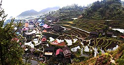
Apart from the county town, Rongshui comprises many small villages and large rural areas. The county is mountainous, featuring both karst landscapes and larger mountain massifs such as the mountains. The river Rong (Rongjiang) flows through the county and passes by Rongshui town. The longest river within the county is the Bei River (Beijiang, not to be confused with the Beijiang tributary to the Zhujiang).
Administrative divisions[]
Rongshui County has 4 towns, 16 townships and 204 villages under its administration.
The towns include Rongshui, Hemu, Huaibao, and Sanfang.
The townships are Anchui, Antai, Baiyun, Dalang, Danian, Dongtou, Gandong, Gongdong, Gunbei, Hongshui, Liangzhai, Sirong, Tonglian, Wangdong, Xiangfen, and Yongle.
Transport[]
Highway G209 provides access to Rongshui from Liuzhou in the south and in the north (with highway G321 connecting from Guyizheng to Guiyang, the capital of Guizhou province, in the west).
Rongshui is serviced by trains connecting with Liuzhou in the south and Huaihua (Hunan) in the north, branching off to larger cities such as Guiyang (Guizhou), Changsha (Hunan), Wuhan (Hubei) and Zhengzhou (Henan).
Culture[]
Rongshui is known for the frequent festivals of its Miao population.
Their celebrations include the drum festival, sowing festival, seedling festival and horse-fighting festivals. The festivities are often accompanied by music played on the Lusheng, a reed-pipe wind instrument, and dancing and singing performances.
Climate[]
| showClimate data for Rongshui (1981−2010) |
|---|
See also[]
References[]
- ^ Liuzhou City Land Use Plan (2006–20)/《柳州市土地利用总体规划(2006-2020年)》.(in Chinese) Accessed 8 July 2014.
- ^ 《中国2010年人口普查分县资料》 (in Chinese). 中国统计出版社. December 2012. ISBN 978-7-5037-6659-6.
- ^ Google (2014-07-02). "Rongshui" (Map). Google Maps. Google. Retrieved 2014-07-02.
- ^ (in Chinese) Recent population data for Rongshui Miao Autonomous County, official website of Rongshui County government, visited on July 3, 2009.
- ^ (in Chinese) Distribution of ethnic minorities in Rongshui Miao Autonomous County, official website of Rongshui County government, visited on July 3, 2009.
External links[]
- Official website of Rongshui County government
- Miao ethnic group celebrates Xinhe Festival
- Schoolkids tuck into free lunches in Guangxi
- Horsefight held to mark "Gulongpo Fair"
- Rongshui photos on Flickr
| show Authority control |
|---|
- Miao autonomous counties
- County-level divisions of Guangxi
- Liuzhou