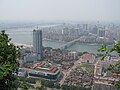
Fangchenggang
This article needs additional citations for verification. (November 2015) |
Fangchenggang
防城港市 • Fangzcwngzgangj Si | |
|---|---|
 | |
 Location of Fangchenggang City jurisdiction in Guangxi | |
 Fangchenggang Location in China | |
| Coordinates (Fangchenggang government): 21°41′12″N 108°21′17″E / 21.6867°N 108.3547°ECoordinates: 21°41′12″N 108°21′17″E / 21.6867°N 108.3547°E | |
| Country | People's Republic of China |
| Region | Guangxi |
| Municipal seat | Gangkou District |
| Area | |
| • Total | 6,181 km2 (2,386 sq mi) |
| Population (2010) | |
| • Total | 860,100 |
| • Density | 140/km2 (360/sq mi) |
| Time zone | UTC+8 (China Standard) |
| Postal code | 538000 |
| Area code(s) | 0770 |
| ISO 3166 code | CN-GX-06 |
| Website | fcgs |

| Fangchenggang | |||||||||||
|---|---|---|---|---|---|---|---|---|---|---|---|
| Chinese name | |||||||||||
| Chinese | 防城港市 | ||||||||||
| |||||||||||
| Vietnamese name | |||||||||||
| Vietnamese | Thành phố Phòng Thành Cảng / Phòng Thành Cảng thị | ||||||||||
| Chữ Hán | 防城港市 | ||||||||||
| Chữ Nôm | 城庯防城港 | ||||||||||
| Zhuang name | |||||||||||
| Zhuang | Fangzcwngzgangj Si | ||||||||||
| 1957 orthography | Faŋƨcɯŋƨgaŋз Si | ||||||||||
Fangchenggang (Chinese: 防城港 ''The port of Fangcheng'') is a prefecture-level city in the south of Guangxi Zhuang Autonomous Region, People's Republic of China. The city was formerly called "Fangcheng Pan-Ethnicities Autonomous County" (25 December 1978 – 23 May 1993).[1]
Fangcheng, is the southernmost port in China and is located in Fangchenggang. It primarily services bulk carriers, of up to 180,000 deadweight tonnes in size.[2] The closest airport is located in Nanning, about 170 km away (4 hours drive).[3] As of December 2018, the region had large amounts of land reclamation in progress to build new and additional ports.[4]
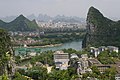
Geography and climate[]
Fangchenggang is a coastal city in southern Guangxi, bordering Vietnam. Its area is 6,181 km2 (2,386 sq mi), 120 km2 (46 sq mi) of that urban.
| Climate data for Fangchenggang (1981–2010) | |||||||||||||
|---|---|---|---|---|---|---|---|---|---|---|---|---|---|
| Month | Jan | Feb | Mar | Apr | May | Jun | Jul | Aug | Sep | Oct | Nov | Dec | Year |
| Record high °C (°F) | 26.3 (79.3) |
28.1 (82.6) |
29.8 (85.6) |
33.0 (91.4) |
34.5 (94.1) |
37.4 (99.3) |
36.5 (97.7) |
37.4 (99.3) |
36.9 (98.4) |
33.6 (92.5) |
31.2 (88.2) |
28.1 (82.6) |
37.4 (99.3) |
| Average high °C (°F) | 17.5 (63.5) |
18.7 (65.7) |
21.1 (70.0) |
25.7 (78.3) |
29.2 (84.6) |
30.5 (86.9) |
31.1 (88.0) |
31.3 (88.3) |
30.8 (87.4) |
28.7 (83.7) |
24.7 (76.5) |
20.4 (68.7) |
25.8 (78.5) |
| Daily mean °C (°F) | 14.3 (57.7) |
15.7 (60.3) |
18.2 (64.8) |
22.8 (73.0) |
26.3 (79.3) |
28.1 (82.6) |
28.6 (83.5) |
28.3 (82.9) |
27.4 (81.3) |
25.0 (77.0) |
20.9 (69.6) |
16.8 (62.2) |
22.7 (72.9) |
| Average low °C (°F) | 12.0 (53.6) |
13.6 (56.5) |
16.1 (61.0) |
20.9 (69.6) |
24.1 (75.4) |
25.9 (78.6) |
26.3 (79.3) |
25.8 (78.4) |
24.8 (76.6) |
22.4 (72.3) |
18.1 (64.6) |
14.2 (57.6) |
20.4 (68.6) |
| Record low °C (°F) | 4.0 (39.2) |
2.8 (37.0) |
7.5 (45.5) |
9.1 (48.4) |
15.3 (59.5) |
21.3 (70.3) |
22.2 (72.0) |
21.4 (70.5) |
16.1 (61.0) |
15.0 (59.0) |
7.7 (45.9) |
3.5 (38.3) |
2.8 (37.0) |
| Average relative humidity (%) | 74 | 81 | 84 | 85 | 83 | 86 | 84 | 83 | 78 | 71 | 67 | 67 | 79 |
| Source: China Meteorological Data Service Center | |||||||||||||
Administration[]
Fangchenggang has 2 urban districts, 1 county, 1 county-level city, 19 townships, 13 towns, 283 villages, and 19 sub-districts.
Districts:
- Gangkou District (港口区)
- Fangcheng District (防城区)
County-level city:
- Dongxing (东兴市)
County:
- Shangsi County (上思县)
| Map |
|---|

Demographics[]
Fangchenggang has a total population of 717,966. Ethnic groups and their corresponding numbers are Han 390,286 or 54.36%, Zhuang 287,207 or 40% Yao 26,749 or 3.73%, Jing 12,288 or 1.71% and all other minorities combined 1,436 or 0.02%. Population density is 116 people per km2 and population growth is 7.75% annually.
Economy[]
Fanchenggang, the last part of which "gang" means port is as its name implies an important port for Guangxi, and other than Beihai the only major Chinese port on the Tonkin Gulf.
Besides port related industries there is substantial tourism, commercial fishing, hydropower, food and beverage production, and agriculture. Agricultural products include rice, corn, peanuts, oranges, and sugarcane. Other natural resources are coal, limestone, and spring water. The first phase of Fangchenggang Nuclear Power Plant, a nuclear power plant project is under construction here.
Fangchenggang is served by a railway branch from Qinzhou East through a half an hour train journey and to Nanning, a one and a half hour train ride. Since the end of 2013, the city's Fangchenggang North Railway Station has high-speed (D-series) train service from Nanning. As of March 2019, there were two trains daily (T type) to Qinzhou and 9 trains (D type) daily to Nanning railway station.[5]
Flora and fauna[]
Like much of Guangxi, there are many forested mountains and stream filled valleys. The area along the border with Vietnam is relatively undeveloped and draws considerable tourism. Fangchenggang's forests contain more than 500 types of plants, more than 4000 medicinal plants and herbs, 25 species of mammals, and many species of insects, reptiles, amphibians, and birds. Many nationally protected animals can still be found in Fangchenggang such as gibbons, frogs, butterflies, and tortoises. In the ocean waters, whales, dolphins, and dugongs can be seen.
References[]
- ^ "China's Fangchenggang: natural beauty and port economy". Sino-US.com. 9 June 2013. Retrieved 6 February 2016.
- ^ Guide to port entry. London: IHS Port guides. 4 January 2018.
- ^ "Port of Fang cheng - port details". Searates.
{{cite web}}: Missing or empty|url=(help) - ^ "Ships currently in Fangcheng port". www.marinetraffic.com. Marine traffic. Retrieved 4 January 2019.
- ^ Fangchenggang North train schedule
External links[]
| |||||||||||||||||||||||||||||||||||||||||||||||||||||||||||||||||||||||||||||||||||||||||||||||||||||||||||||||||||||||||||||||||||||||||||||||||||||||||||||||||||||||||||||


- Cities in Guangxi
- Prefecture-level divisions of Guangxi
- Gulf of Tonkin