Wanning
Wanning
万宁市 | |
|---|---|
County-level & Sub-prefectural city | |
 Wancheng Town the seat of Wanning | |
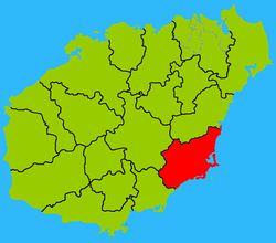 Map showing entire Qionghai area within Hainan province | |
| Coordinates: 18°47′0″N 110°23′0″E / 18.78333°N 110.38333°E | |
| Country | People's Republic of China |
| Province | Hainan |
| Area | |
| • Total | 4,443 km2 (1,715 sq mi) |
| • Land | 1,883.5 km2 (727.2 sq mi) |
| • Water | 2,550 km2 (980 sq mi) |
| Population (2010) | |
| • Total | 545,597 |
| • Density | 120/km2 (320/sq mi) |
| Time zone | UTC+8 (China standard time) |

| Wanning | |||||||||||||
|---|---|---|---|---|---|---|---|---|---|---|---|---|---|
| Traditional Chinese | 萬寧 | ||||||||||||
| Simplified Chinese | 万宁 | ||||||||||||
| Postal | Manning | ||||||||||||
| Literal meaning | Uncountably Long Peace | ||||||||||||
| |||||||||||||
| Wikivoyage has a travel guide for Wanning. |
Wanning or in local Hainanese dialect as Ban Ning is a county-level city in the southeast of Hainan Province, China. Although called a "city", Wanning refers to both the county seat and to the entire county as a whole. The county-wide area has an estimated population of 65,871 (2006).
History[]
Wanning (万宁) first got its current name during the Southern Song Dynasty, after being renamed from Wan'an (万安县). Wanning was later renamed back to Wan'an again in 1143 until its name was changed to Wanzhou (万州) in 1370, but subsequently reverted to its present name after the Communist takeover in the 1950s. It was promoted from a county to a city on August 5, 1996.
Economy[]
Tourism plays a vital role in the city. Famous for its tropical scenery, Wanning proper lies approximately half an hour's drive from the beach and has several five-star hotels. The city of Wanning produces coffee, black pepper, rubber, rice, bananas, and sugarcane.
Transportation[]
Wanning is served by the Wanning Railway Station, part of the Hainan East Ring Intercity Rail.
Climate[]
Wanning is hot most of the year. At times it can become cold with temperatures between 5 and 8 degrees Celsius.
| Climate data for Wanning (1981−2010) | |||||||||||||
|---|---|---|---|---|---|---|---|---|---|---|---|---|---|
| Month | Jan | Feb | Mar | Apr | May | Jun | Jul | Aug | Sep | Oct | Nov | Dec | Year |
| Record high °C (°F) | 30.3 (86.5) |
30.7 (87.3) |
32.4 (90.3) |
34.0 (93.2) |
35.9 (96.6) |
37.1 (98.8) |
36.7 (98.1) |
36.5 (97.7) |
35.7 (96.3) |
33.5 (92.3) |
31.4 (88.5) |
30.6 (87.1) |
37.1 (98.8) |
| Average high °C (°F) | 23.3 (73.9) |
24.4 (75.9) |
26.7 (80.1) |
29.6 (85.3) |
31.6 (88.9) |
32.2 (90.0) |
32.4 (90.3) |
32.3 (90.1) |
31.1 (88.0) |
29.1 (84.4) |
26.4 (79.5) |
23.7 (74.7) |
28.6 (83.4) |
| Daily mean °C (°F) | 19.5 (67.1) |
20.9 (69.6) |
23.2 (73.8) |
26.1 (79.0) |
27.9 (82.2) |
28.8 (83.8) |
28.8 (83.8) |
28.4 (83.1) |
27.3 (81.1) |
25.8 (78.4) |
23.0 (73.4) |
20.2 (68.4) |
25.0 (77.0) |
| Average low °C (°F) | 16.8 (62.2) |
18.4 (65.1) |
20.7 (69.3) |
23.7 (74.7) |
25.2 (77.4) |
26.1 (79.0) |
26.0 (78.8) |
25.5 (77.9) |
24.5 (76.1) |
23.1 (73.6) |
20.5 (68.9) |
17.6 (63.7) |
22.3 (72.2) |
| Record low °C (°F) | 8.0 (46.4) |
8.7 (47.7) |
7.4 (45.3) |
15.2 (59.4) |
17.1 (62.8) |
21.3 (70.3) |
21.9 (71.4) |
22.4 (72.3) |
20.2 (68.4) |
14.7 (58.5) |
11.7 (53.1) |
7.2 (45.0) |
7.2 (45.0) |
| Average precipitation mm (inches) | 46.8 (1.84) |
38.0 (1.50) |
63.9 (2.52) |
112.6 (4.43) |
189.0 (7.44) |
181.5 (7.15) |
202.3 (7.96) |
193.7 (7.63) |
355.4 (13.99) |
383.8 (15.11) |
174.8 (6.88) |
100.1 (3.94) |
2,041.9 (80.39) |
| Average relative humidity (%) | 85 | 86 | 85 | 85 | 83 | 83 | 82 | 84 | 85 | 84 | 83 | 83 | 84 |
| Source: China Meteorological Data Service Center[1] | |||||||||||||
References[]
- ^ 中国地面气候标准值月值(1981-2010) (in Simplified Chinese). China Meteorological Data Service Center. Retrieved 15 October 2019.
Hainan topics | |
|---|---|
Haikou (capital) | |
| General |
|
| Geography |
|
| Flora and fauna |
|
| Media |
|
| Transportation |
|
| Education |
|
| Demographics |
|
| Buildings and structures |
|
| Cuisine |
|
| Visitor attractions |
|
| |
County-level divisions of Hainan Province | ||||||||||||||||||
|---|---|---|---|---|---|---|---|---|---|---|---|---|---|---|---|---|---|---|
Haikou (capital) | ||||||||||||||||||
| Prefecture-level cities |
|  | ||||||||||||||||
| Provincial administered |
| |||||||||||||||||
| ||||||||||||||||||
Notes: *Provincial capitals, ★Sub-provincial cities, ☆Sub-provincial autonomous prefecture *Sub prefectural-level divisions, ✧Largest cities that will approved by the State Council | ||||||||||||||||||||||||||||||||||||||||||||||||||||||||||||||||
|  | |||||||||||||||||||||||||||||||||||||||||||||||||||||||||||||||
|
Coordinates: 18°48′N 110°24′E / 18.800°N 110.400°E
This Hainan location article is a stub. You can help Wikipedia by . |
- Cities in Hainan
- Hainan geography stubs