Dengta
Dengta
灯塔市 | |
|---|---|
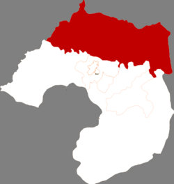 Location in Liaoyang | |
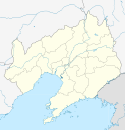 Dengta Location in Liaoning | |
| Coordinates: 41°26′N 123°20′E / 41.433°N 123.333°ECoordinates: 41°26′N 123°20′E / 41.433°N 123.333°E | |
| Country | People's Republic of China |
| Province | Liaoning |
| Prefecture-level city | Liaoyang |
| Area | |
| • County-level city | 1,166.0 km2 (450.2 sq mi) |
| • Urban | 127.00 km2 (49.03 sq mi) |
| Elevation | 44 m (143 ft) |
| Population (2017)[1] | |
| • County-level city | 442,000 |
| • Density | 380/km2 (980/sq mi) |
| • Urban | 109,600 |
| Time zone | UTC+8 (China Standard) |

Dengta (simplified Chinese: 灯塔; traditional Chinese: 燈塔; pinyin: Dēngtǎ; lit. 'Lighthouse') is a city in east-central Liaoning province in Northeast China. It is located in between Liaoyang, which oversees Dengta and lies 22 kilometers (14 mi) to the southwest, and Shenyang, the provincial capital which lies nearly double that distance to the northeast.
Administrative Divisions[2][]
There are three subdistricts, 12 towns and one township under the city's administration.
Subdistricts:
- (万宝桥街道), (烟台街道), (古城街道)
Towns:
- (灯塔镇), (铧子镇), (张台子镇), (西大窑镇), (佟二堡镇), (沈旦堡镇), (柳条寨镇), (西马峰镇), (王家镇), (柳河子镇), (罗大台镇), (大河南镇)
The only township is (鸡冠山乡)
References[]
- ^ a b Ministry of Housing and Urban-Rural Development, ed. (2019). China Urban Construction Statistical Yearbook 2017. Beijing: China Statistics Press. p. 50. Retrieved 11 January 2020.
- ^ 辽阳市-行政区划网
External links[]
This Liaoning location article is a stub. You can help Wikipedia by . |
Categories:
- County-level divisions of Liaoning
- Liaoyang
- Liaoning geography stubs