Benxi Manchu Autonomous County
Benxi
本溪县 ᠪᡝᠨᠰᡳ ᠰᡳᠶᠠᠨ | |
|---|---|
| 本溪满族自治县 ᠪᡝᠨᠰᡳ ᠮᠠᠨᠵᡠ ᠪᡝᠶᡝ ᡩᠠᠰᠠᠩᡤᠠ ᠰᡳᠶᠠᠨ Benxi Manchu Autonomous County | |
 Benxi County in Benxi City | |
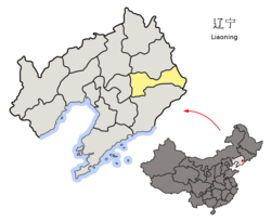 Benxi City in Liaoning | |
| Coordinates: 41°18′06″N 124°07′12″E / 41.3018°N 124.1200°ECoordinates: 41°18′06″N 124°07′12″E / 41.3018°N 124.1200°E | |
| Country | People's Republic of China |
| Province | Liaoning |
| Prefecture-level city | Benxi |
| County seat | Xiaoshi |
| Area | |
| • Total | 3,362 km2 (1,298 sq mi) |
| Elevation | 205 m (673 ft) |
| Population (2002) | |
| • Total | 300,000 |
| • Density | 89/km2 (230/sq mi) |
| Time zone | UTC+8 (China Standard) |
| Postal code | 117100 |
| Area code(s) | 0414 |

Benxi Manchu Autonomous County (simplified Chinese: 本溪满族自治县; traditional Chinese: 本溪滿族自治縣; pinyin: Běnxī Mǎnzú Zìzhìxiàn; Manchu: ᠪᡝᠨᠰᡳ
ᠮᠠᠨᠵᡠ
ᠪᡝᠶᡝ
ᡩᠠᠰᠠᠩᡤᠠ
ᠰᡳᠶᠠᠨ
; Mölendroff: bensi manju beye dasangga siyan) is an autonomous county under the administration of the prefecture-level city of Benxi, in the east of Liaoning province, China. It has a total area of 3,362 square kilometres (1,298 sq mi), and a population of approximately 300,000 people as of 2002.
The city is home to a sizable Manchu and Hui population.
Administrative divisions[]
There is one subdistrict, 11 towns, and one townships within the county:[1]
The only subdistrict is Guanyinge Subdistrict (观音阁街道)
Towns:
The only township is (东营房乡)
References[]
- ^ 2011年统计用区划代码和城乡划分代码:本溪县 (in Chinese). National Bureau of Statistics of the People's Republic of China. Retrieved 2012-12-25.[permanent dead link]
External links[]


| show Authority control |
|---|
This Liaoning location article is a stub. You can help Wikipedia by . |
Categories:
- County-level divisions of Liaoning
- Manchu autonomous counties
- Liaoning geography stubs