Oroqen Autonomous Banner
This article does not cite any sources. (December 2009) |
Oroqen Banner
鄂伦春旗 • ᠣᠷᠴᠣᠨ ᠤᠬᠣᠰᠢᠭᠤ | |
|---|---|
| Oroqen Autonomous Banner 鄂伦春自治旗 ᠣᠷᠴᠣᠨ ᠤᠥᠪᠡᠷᠲᠡᠭᠡᠨᠵᠠᠰᠠᠬᠤᠬᠣᠰᠢᠭᠤ | |
 | |
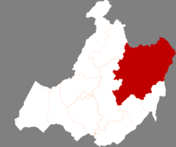 Location in Hulunbuir | |
 Oroqen Location in Inner Mongolia | |
| Coordinates: 50°35′N 123°43′E / 50.583°N 123.717°ECoordinates: 50°35′N 123°43′E / 50.583°N 123.717°E | |
| Country | People's Republic of China |
| Region | Inner Mongolia |
| Prefecture-level city | Hulunbuir |
| Area | |
| • Total | 60,378 km2 (23,312 sq mi) |
| Population (2010) | |
| • Total | 223,752 |
| • Density | 3.7/km2 (9.6/sq mi) |
| Time zone | UTC+8 (China Standard) |

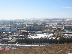
Oroqen Autonomous Banner (Mongolian: ᠣᠷᠴᠣᠨ ᠤ ᠥᠪᠡᠷᠲᠡᠭᠡᠨ ᠵᠠᠰᠠᠬᠤ ᠬᠣᠰᠢᠭᠤ, Orčon-u öbertegen jasaqu qosiɣu, Mongolian Cyrillic: Орчон өөртөө засах хошуу; Simplified Chinese: 鄂伦春自治旗, Pinyin: Èlúnchūn Zìzhìqí) is an autonomous banner that lies directly south of the urban district of Hailar in the prefecture-level city of Hulunbuir. It covers an area of 60,378 square kilometres (23,312 sq mi). As of the 2010 census, there were 223,752 inhabitants with a population density of 4.84 inhabitants per km2. Its capital is the town of Alihe (阿里河镇). It includes Ganhe (甘河), Dayangshu (大杨树), Jiwen (吉文) but excludes the Jiagedaqi and Songling Districts.

Map including part of Oroqen Autonomous Banner (AMS, 1951)

Map including part of Oroqen Autonomous Banner (AMS, 1951)

Map including part of Oroqen Autonomous Banner (AMS, 1951)
Ethnic groups in Oroqen Autonomous Banner, 2000 census[]
| Nationality | Population | Percentage |
|---|---|---|
| Han | 257,861 | 88.28% |
| Mongols | 12,045 | 4.12% |
| Manchu | 8,743 | 2.99% |
| Daur | 6,379 | 2.18% |
| Evenks | 3,155 | 1.08% |
| Oroqen | 2,050 | 0.7% |
| Hui | 1,038 | 0.36% |
| Korean | 633 | 0.22% |
| Xibe | 54 | 0.02% |
| Russians | 37 | 0.01% |
| Others | 102 | 0.04% |
This Inner Mongolia location article is a stub. You can help Wikipedia by . |
Categories:
- Autonomous counties of the People's Republic of China
- County-level divisions of Inner Mongolia
- Oroqen people
- Hulunbuir
- Inner Mongolia geography stubs