Ergun City
Ergun
额尔古纳市 • ᠡᠷᠬᠥᠨᠠᠬᠣᠲᠠ | |
|---|---|
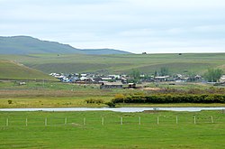 Village on the Argun River | |
 Ergun in Hulunbuir | |
 Ergun Location in Inner Mongolia | |
| Coordinates: 50°14′35″N 120°10′52″E / 50.243°N 120.181°ECoordinates: 50°14′35″N 120°10′52″E / 50.243°N 120.181°E | |
| Country | People's Republic of China |
| Autonomous region | Inner Mongolia |
| Prefecture-level city | Hulunbuir |
| Area | |
| • County-level city | 28,400 km2 (11,000 sq mi) |
| • Urban | 303.00 km2 (116.99 sq mi) |
| Population (2017) | |
| • County-level city | 85,162 |
| • Density | 3.0/km2 (7.8/sq mi) |
| • Urban | 38,100 |
| Time zone | UTC+8 (China Standard) |
| Postal code | 022050 |
| Area code(s) | 0470 |
| Website | www |

Ergun (simplified Chinese: 额尔古纳市; traditional Chinese: 額爾古納市; pinyin: É'ěrgǔnà-shì; Mongolian: Эргүн Ergün), formerly Ergun Right Banner (Mongolian: ᠡᠷᠬᠥᠨᠠ ᠬᠣᠲᠠ Эргүнэ хот; Chinese: 额尔古纳右旗; pinyin: E'erguna You Qi), is a county-level city in Hulunbuir, Inner Mongolia, containing the autonomous region's northernmost point. The city has an area of 28,958 square kilometres (11,181 sq mi),[2] and a population of 79,155 as of the 2019.[3]: 20–1
History[]
For most of its history, the region of present-day Ergun has not been controlled by Chinese states.[4] The area first came under Chinese control during the Qing dynasty, when it was administered as part of Hulunbuir.[4]
In 1908, the (Chinese: 吉拉林设治局; pinyin: Jílālín Shèzhì Jú) was established to govern the area.[4]
In 1920, the area was re-organized as the (Chinese: 奇乾设治局; pinyin: Qígān Shèzhì Jú), but the area was re-organized again in 1921 as Qigan County (Chinese: 奇乾县; pinyin: Qígān Xiàn).[4]
In 1933, the area was re-organized as Ergun Right Banner (Chinese: 额尔古纳右旗; pinyin: É'ěrgǔnà Yòu Qí).[4] From 1948 to 1966, Ergun Right Banner was merged with , which occupied present-day Genhe, as Ergun Left Banner.[4] In 1994, Ergun Right Banner was abolished and the county-level city of Ergun was established.[4]
21st century[]
By 2000, the city administered five towns, one township, and two ethnic townships.[4] In 2001, the city was restructured to administer one subdistrict, two towns, one township, and two ethnic townships.[4]
In 2006, Xincheng Subdistrict (Chinese: 新城街道; pinyin: Xīnchéng Jiēdào) was renamed to , and Shangkuli Township (Chinese: 上库力乡; pinyin: Shàngkùlì Xiāng) was upgraded to .[4]
In 2011, Shiwei Russian Ethnic Township (Chinese: 室韦俄罗斯族民族乡; pinyin: Shìwéi Èluósī Zú Mínzú Xiāng) was abolished and Enhe Russian Ethnic Township and Mengwu Shiwei Sum were established.[4] was also established.[4]
In 2013, was established.[4]
Geography[]

Administratively, Ergun is part of the prefecture-level city of Hulunbuir, and spans 11.4% of Hulunbuir's area.[2][5] It occupies 28,958 square kilometres (11,181 sq mi), bounded to the north and west by the Argun River, which forms China's border with Russia's Zabaykalsky Krai (formerly, Chita Oblast).[2][6] The city's border with Russia spans 675 kilometres (419 mi).[2] Ergun is also bordered by Genhe to the east, and the county-level city of Mohe in Heilongjiang to the northeast.[2]
The city stands at the foothills of the Greater Khingan Mountains.[2] 73.4% of the city's area is forested, with much of it being virgin forests.[2][5] 17% of the city's area is natural grassland, particularly in the city's south, and 6% is cultivated.[2]
Apart from the Argun River, major rivers in the city include the , the , the , the , the , and the , all of which are tributaries of the Argun River.[2]

Ergun Wetlands[]
The city hosts Ergun Wetlands (formerly known as the Genhe Wetlands), a plain delta formed by the Argun River, the , the , and the .[citation needed] The Ergun Wetlands is one of the largest wetlands in Asia, lying about 3 km to the west of , Ergun's urban area and seat of government.[citation needed]
After the end of September the wetlands wither and turn dark.[7] A panoramic view of the wetlands is afforded from a tourist scenic view overlooking the area from a hill 720 meters above sea level.[8]
The encroachment of urban development has made preservation of the wetland difficult but were bolstered by a wetland protection law in 2012.[9]
Climate[]
The city experiences an average annual temperature of −3.1 °C (26.4 °F), and an average annual precipitation of 375 millimetres (14.8 in).[2]
Administration[]
The city's seat of government is located in .[2][10]
Subdivisions[]
Ergun is divided into two subdistricts, three towns, one township, two ethnic townships, one sum, and four township-level farms.[11]
| English Name | Subdivision type | Chinese | Population (2010)[4] |
|---|---|---|---|
| Subdistrict | Chinese: 拉布大林街道; pinyin: Lābùdàlín Jiēdào | 35,727 | |
| Subdistrict | Chinese: 上库力街道; pinyin: Shàngkùlì Jiēdào | 6,708 | |
| Town | Chinese: 黑山头镇; pinyin: Hēishāntóu Zhèn | 2,029 | |
| Town | Chinese: 莫尔道嘎镇; pinyin: Mò'ěrdàogā Zhèn | 17,970 | |
| Town | Chinese: 恩和哈达镇; pinyin: Ēnhéhādá Zhèn | N/A | |
| Township | Chinese: 奇乾乡; pinyin: Qígān Xiāng | N/A | |
| Sanhe Hui Ethnic Township | Ethnic Township | Chinese: 三河回族乡; pinyin: Sānhé Huí Zú Xiāng | 10,648 |
| Enhe Russian Ethnic Township | Ethnic Township | Chinese: 恩和俄罗斯族乡; pinyin: Ēnhé Èluósī Zú Xiāng | N/A |
| Mengwu Shiwei Sum | Sum | Chinese: 蒙兀室韦苏木; pinyin: Méngwù Shìwéi Sūmù | N/A |
| Township-level farm | Chinese: 内蒙古拉布大林农牧场; pinyin: Nèi Ménggǔ Lābùdàlín Nóngmùchǎng | N/A | |
| Township-level farm | Chinese: 内蒙古三河种马场; pinyin: Nèi Ménggǔ Sānhé Zhǒngmǎchǎng | N/A | |
| Township-level farm | Chinese: 内蒙古上库力农场; pinyin: Nèi Ménggǔ Shàngkùlì Nóngchǎng | N/A | |
| Township-level farm | Chinese: 内蒙古苏沁农牧场; pinyin: Nèi Ménggǔ Sūqìn Nóngmùchǎng | N/A |
Demographics[]
Ergun is one of the least populated county-level divisions of Inner Mongolia, with a population of 79,155 as of 2019, making it the 87th most populated of the autonomous region's 103 divisions.[3]: 20–1 This figure reflects a 1.0% decline from the 2018 population of 79,942.[3]: 20–37 [12] As of 2010, Ergun had a population of 76,667.[4]
Ethnicity[]
| Ethnic group | 2000[4] | 2006[13] | 2018[12] | |||
|---|---|---|---|---|---|---|
| Number | Percentage | Number | Percentage | Number | Percentage | |
| Han Chinese | 62,224 | 77.43% | 64,591 | 75.84% | 58,778 | 73.53% |
| Mongol | 4,839 | 6.02% | 7,294 | 8.56% | 7,897 | 9.88% |
| Hui | 6,616 | 8.23% | N/A | N/A | 6,583 | 8.23% |
| Russian | 2,713 | 3.38% | 2,468 | 2.90% | 2,613 | 3.27% |
| Manchu | 2,713 | 3.38% | N/A | N/A | N/A | N/A |
| Daur | 763 | 0.95% | N/A | N/A | N/A | N/A |
| Korean | 182 | 0.23% | N/A | N/A | N/A | N/A |
| Evenk | 156 | 0.19% | N/A | N/A | N/A | N/A |
| Oroqen | 63 | 0.08% | N/A | N/A | N/A | N/A |
| Miao | 55 | 0.07% | N/A | N/A | N/A | N/A |
| Tujia | 29 | 0.04% | N/A | N/A | N/A | N/A |
| Sibe | 3 | <0.01% | N/A | N/A | N/A | N/A |
| Yi | 2 | <0.01% | N/A | N/A | N/A | N/A |
| Other | 0 | 0.00% | 10,809 | 12.69% | 4,071 | 5.09% |
| Total | 80,358 | 100.00% | 85,162 | 100.00% | 79,942 | 100.00% |
In Ergun's towns and villages along the Argun River are thousands of descendants of intermarriages between Han Chinese men and Russian women.[14] This Russian descended population forms a large portion of the total number of Russians in China. One of these locations is Enhe Russian Ethnic Township, the sole official ethnic Russian township.[14]
Economy[]
Ergun's gross domestic product was ¥4.059 billion as of 2019,[3]: 20–37 [15] and ¥4.519 billion as of 2018.[12] As of 2018, 42.1% of the city's gross domestic product came from its primary sector, 11.1% came from its secondary sector, and 46.8% came from its tertiary sector.[12] The city's public budget revenue in 2019 was ¥150.55 million, ranking 91st out of Inner Mongolia's 103 county-level divisions.[3]: 20–4 Its consumer retail sales totaled ¥1.826 billion, and its foreign trade totaled 56.32 million USD.[12]
| Sector | 2018[12] | 2019[3]: 20–37 | ||
|---|---|---|---|---|
| Total (RMB) | Percent of whole | Total (RMB) | Percent of whole | |
| Primary | 1.902 billion | 42.09% | 1.70576 billion | 42.02% |
| Secondary | 0.502 billion | 11.11% | 0.45242 billion | 11.14% |
| Tertiary | 2.115 billion | 46.80% | 1.90133 billion | 46.84% |
| Total | 4.519 billion | 100.00% | 4.05951 billion | 100.00% |
The average household disposable income of Ergun's residents totaled ¥30,371 in 2019, a 7.8% increase from the ¥28,173 reported in 2018.[3]: 20–37 [12] For urban households, this number stood at ¥30,953 in 2019,[3]: 20–37 a 7.0% increase from the ¥28,928 reported in 2018,[3]: 20–37 [12] which ranked 75th of the 101 county-level divisions in Inner Mongolia for which this statistic was reported.[3]: 20–5 Rural households in Ergun average ¥28,470 in disposable income as of 2019,[3]: 20–37 a 10.0% increase from 2018,[3]: 20–37 which ranked the 3rd highest of the 90 county-level divisions in Inner Mongolia which reported this statistic.[3]: 20–6
As of 2019, there are 99,140 mobile telephone subscriptions in Ergun (1.25 per capita), and 28,962 internet subscriptions (0.37 per capita).[3]: 20–37
Mineral deposits in Ergun include coal, gold, lead, zinc, iron, tungsten, copper, and fluorite.[2]
Agriculture[]
The total value of Ergun's agriculture, forestry, animal husbandry, and aquaculture industry as of 2018 was ¥3.072 billion.[12]
In 2019, Ergun produced 263,482 tons of grain, the 37th most of the 96 county-level divisions of Inner Mongolia which reported this statistic.[3]: 20–2 The city produced 9,255 tons of meat the same year, ranking 74th of Inner Mongolia's 103 county-level divisions.[3]: 20–3
Tourism[]
Ergun has a significant tourism industry, attracting 5.733 million tourists in 2019 alone.[15]
The Ergun Wetland Scenic Area (Chinese: 额尔古纳湿地景区) is designated as a AAAA Tourist Attraction.[5]
Enhe Russian Ethnic Township has become a major tourist destination in recent years, attracting about 500,000 tourists in 2017 alone.[16] Much of the town's tourism is derived from its small rural character, as well as its unique intersection of Russian and Chinese culture.[16] Due to the cold climate of the region, most of the ethnic township's tourism takes place in summer months.[16]
Ergun also hosts the ancient ruins of the city of Heishantou and portions of the .[2]
Education[]
As of 2019, the city has 10 primary schools and 5 secondary schools.[3]: 20–37
Healthcare[]
As of 2019, Ergun's medical institutions have 414 beds, and are staffed by 597 personnel.[3]: 20–37
Transportation[]
Ergun hosts 2,430 kilometres (1,510 mi) of highway as of 2019.[3]:���20–37 and both run through Ergun.[2]
Ergun has two international border crossings: one in Shiwei, and another in .[6]
References[]
- ^ Jump up to: a b Ministry of Housing and Urban-Rural Development, ed. (2019). China Urban Construction Statistical Yearbook 2017. Beijing: China Statistics Press. p. 46. Retrieved 11 January 2020.
- ^ Jump up to: a b c d e f g h i j k l m n 额尔古纳市概况地图 [Ergun Overview]. xzqh.org (in Chinese). 2016-01-04. Archived from the original on 2021-02-09. Retrieved 2021-02-09.
- ^ Jump up to: a b c d e f g h i j k l m n o p q r s 内蒙古统计年鉴—2020 [Inner Mongolia Statistical Yearbook 2020]. tj.nmg.gov.cn (in Chinese). Inner Mongolia Autonomous Regional Bureau of Statistics. 2020. Archived from the original on 2021-07-13. Retrieved 2021-07-13.
- ^ Jump up to: a b c d e f g h i j k l m n o p 额尔古纳市历史沿革 [Ergun City Organizational History]. xzqh.org (in Chinese). 2016-01-04. Archived from the original on 2021-02-09. Retrieved 2021-02-09.
- ^ Jump up to: a b c 市情概况 [City Situation] (in Chinese). Ergun Municipal People's Government. 2020-03-11. Archived from the original on 2021-02-09. Retrieved 2021-02-09.
- ^ Jump up to: a b 市情概述 (in Chinese). Archived from the original on 2012-11-28. Retrieved 2009-10-07.
- ^ Wang, Kaihao (October 17, 2013). "River valley produces wetlands wonder". China Daily.
- ^ "Ergun wetland in Inner Mongolia, one of the largest in Asia". ecns.com. November 11, 2013.
- ^ Wang, Qian; Zheng, Jinran (May 14, 2012). "Ergun wetland threatened by development, urbanization". China Daily.
- ^ 额尔古纳市拉布大林街道办事处 (in Chinese). Archived from the original on 2011-07-10. Retrieved 2009-10-07.
- ^ Jump up to: a b 2020年统计用区划代码(额尔古纳) [2020 Statistical Division Codes (Ergun)] (in Chinese). National Bureau of Statistics of China. 2020. Archived from the original on 2021-02-09. Retrieved 2021-02-09.
- ^ Jump up to: a b c d e f g h i 额尔古纳市2018年国民经济和社会发展统计公报 [Ergun City 2018 Economic and Social Development Report] (in Chinese). Ergun Municipal People's Government. 2019-04-01. Archived from the original on 2019-04-13. Retrieved 2021-02-09.
- ^ 额尔古纳市概况 [Description of Ergun City]. Hulunbuir People's Government (in Chinese).[permanent dead link]
- ^ Jump up to: a b Entangled Histories: The Transcultural Past of Northeast China (PDF). London: Springer. 2014. pp. 47–58.
- ^ Jump up to: a b 额尔古纳经济发展概况 [Ergun Economic Development Overview] (in Chinese). Ergun Municipal People's Government. 2020-03-11. Archived from the original on 2021-02-09. Retrieved 2021-02-09.
- ^ Jump up to: a b c Zhang, Wei (2017-08-03). 中国唯一俄罗斯民族乡:异域风情范儿的边疆小镇 [China's only Russian Ethnic Township: An exotic frontier town]. www.chinanews.com (in Chinese). China News Service. Archived from the original on 2021-02-09. Retrieved 2021-02-09.
- Ergun City
- Cities in Inner Mongolia
- Geography of Inner Mongolia
- Hulunbuir