Ordos City
This article needs additional citations for verification. (December 2018) |
Ordos
鄂尔多斯市 • ᠣᠷᠳᠣᠰ ᠬᠣᠲᠠ | |
|---|---|
 Ulan Moron Site Lake in Ordos City | |
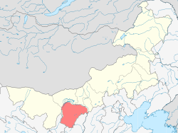 Location of Ordos City jurisdiction in Inner Mongolia (orange) | |
| Coordinates (Genghis Khan Plaza, Kangbashi): 39°36′14″N 109°47′06″E / 39.604°N 109.785°ECoordinates: 39°36′14″N 109°47′06″E / 39.604°N 109.785°E | |
| Country | People's Republic of China |
| Region | Inner Mongolia |
| Municipal seat | Kangbashi District |
| Area | |
| • Prefecture-level city | 86,752 km2 (33,495 sq mi) |
| • Urban (2017)[1] | 2,526.5 km2 (975.5 sq mi) |
| • Metro | 5,859.8 km2 (2,262.5 sq mi) |
| Elevation | 1,305 m (4,281 ft) |
| Highest elevation | 2,149 m (7,051 ft) |
| Lowest elevation | 850 m (2,790 ft) |
| Population (2017 est.) | |
| • Prefecture-level city | 2,035,653 |
| • Density | 23/km2 (61/sq mi) |
| • Urban (2017)[1] | 667,900 |
| • Urban density | 260/km2 (680/sq mi) |
| • Metro | 364,900 |
| • Metro density | 62/km2 (160/sq mi) |
| Time zone | UTC+8 (China Standard) |
| Postal code | 017000 |
| ISO 3166 code | CN-NM-06 |
| GDP (2016) | CNY 441.79 billion (US$ 66.51 billion) |
| GDP per capita (2016) | CNY 215,486 (US$ 32,442) |
| Licence plate prefixes | 蒙K |
| Administrative division code | 150600 |
| Website | www |

| Ordos City | |||
|---|---|---|---|
| Chinese name | |||
| Simplified Chinese | 鄂尔多斯市 | ||
| Traditional Chinese | 鄂爾多斯市 | ||
| Hanyu Pinyin | È'ěrduōsī Shì | ||
| |||
| Mongolian name | |||
| Mongolian Cyrillic | Ордос хот | ||
| Mongolian script | ᠣᠷᠳᠣᠰ ᠬᠣᠲᠠ | ||
| |||
Ordos (Mongolian: ![]() , Ordos; simplified Chinese: 鄂尔多斯; traditional Chinese: 鄂爾多斯; pinyin: È'ěrduōsī) is one of the twelve major subdivisions of Inner Mongolia, China. It lies within the Ordos Plateau of the Yellow River. Although mainly rural, Ordos is administered as a prefecture-level city. Its population was 2,153,638 as of 2020 census. In a 2017 estimation, its built-up (or metro) area made up of Ejin Horo Banner and Kangbashi District was home to 364,900 inhabitants, as Dongsheng District is not conurbated yet.[2]
, Ordos; simplified Chinese: 鄂尔多斯; traditional Chinese: 鄂爾多斯; pinyin: È'ěrduōsī) is one of the twelve major subdivisions of Inner Mongolia, China. It lies within the Ordos Plateau of the Yellow River. Although mainly rural, Ordos is administered as a prefecture-level city. Its population was 2,153,638 as of 2020 census. In a 2017 estimation, its built-up (or metro) area made up of Ejin Horo Banner and Kangbashi District was home to 364,900 inhabitants, as Dongsheng District is not conurbated yet.[2]
Ordos is known for its recently undertaken large scale government projects including most prominently the new Kangbashi District, an urban district planned as a massive civic mall with abundant monuments, cultural institutions and other showpiece architecture. It was the venue for the 2012 Miss World Final.[3]
When it was newly built, the streets of the new Kangbashi district did not have much activity, and the district was frequently described as a "ghost city" by several Western media outlets. However, by 2017, Kangbashi had become more populated with a resident population of 153,000 and around one-third of apartments occupied. In a Forbes article, Wade Shepard noted that "...of the 40,000 apartments that had been built in the new district since 2004, only 500 are still on the market.[4]
Etymology[]
The area had been administered under the Ih Ju League, also spelled Ikh Juu (Mongolian: ᠶᠡᠬᠡ ᠵᠤᠤ ᠠᠶᠢᠮᠠᠭ Yeke Juu ayimaγ; Chinese: 伊克昭盟; pinyin: Yīkèzhāo Méng), since the 17th century.
It was redesignated a prefecture-level city and renamed to Ordos on 26 February 2001. "Ordos" means "palaces" in the Mongolian language.[5]"Ordos" originally referred to a tribe belonging to the Yeke Juu (Ike Chao ‘great monastery’) league and later included the tribe's area, hence the Ordos, or Ordus, the area within the big bend of the Yellow River. Mongolian ordu(n), ord ‘court, residence of a ruler; palace; camp’, also for 'camp bodyguards'. According to Ramstedt -s is a plural suffix; further: ordu, orda; Turkic orta ‘a center’; Mongolian > Turkish orda ‘camp’ > Hindi urdū > English "horde."[6]
The name is sometimes claimed to be related to the eight white yurts of Genghis Khan.[7] Linguistically, the Ordos dialect of Mongolian is quite different from neighboring Chakhar Mongolian.

History[]
Prehistoric civilization[]
At the southern end of the Ordos grassland, there is a river originating from Dingbian County in northwestern Shaanxi, flowing through the Otog Banner and Uxin Banner in Inner Mongolia, and then flowing from the east of Batuwan Village into the territory of northern Shanxi, after converging with Xiangshui River. It flows into the Wuding River, a tributary of the Yellow River, to the southeast. In the loose Mu Us desert, a “U” shaped river valley is washed out. This river is known as the Sarawusu River. Sara Wusu in Mongolian means "thick yellow stream" after the eponymous perennially yellow-colored local river; on both sides of the river is covered with swaying red willows, so people also call this river "Hongliu River". It is in this river. In 1922, the French Catholic priest Sang Zhihua first discovered a fossil of the "Hetao People" here. Since then, Chinese archaeologists have visited the site many times. A large number of cultural relics have been discovered, and as early as 35,000 years ago, "Hetao people" lived here. The material culture created by the “Hetao People” is now called “Salawusu Culture”. After a comprehensive analysis of geology, animal fossils and stone tools, the Sarawusu culture was identified as the late Paleolithic culture.
Hetao civilization is the product of the integration of grassland culture and Yellow River civilization. Its long-term development and complex transmutation process, especially the relationship with Urad and Ordos Mongolian culture, also illustrates the relationship between Hetao civilization and Yellow River civilization. Hetao culture is one of the important components of the mainstream culture of the northern grasslands. In the grassland culture, the Hetao culture is both a source and a stream. As a source, Hetao culture has a historical accumulation of symbiosis with the northern grassland culture. As a stream, it is different from the Mongolian classic culture in the eastern part of Inner Mongolia, such as Hongshan culture and Khorchin Mongols culture. It has its unique development trend. In the origin of grassland culture, it is a source of the late Paleolithic period, which originated from the prosperity of ancient ethnic minorities. It was formed in the Qin, Han, Ming and Qing Dynasties, and it is a cultural system of modern and contemporary civilization. It is an independent unit culture circle of grassland culture and a complete regional cultural system, which plays an important role in the composition of grassland culture.
Ancient history[]
Before the Zhou Dynasty, it was a nomadic area such as the Guifang and Lin Hu. In the Warring States Period, it was the Yunzhong County of the Zhao State Territory, and later belonged to the Qin State. At the beginning of the Han Dynasty, it was the front line of the Xiongnu and Han wars. Emperor Wu of Han Dynasty set up the Shuofang County here. When Emperor Xuan of Han called the Huxie Chanyu to come, he became the residence of the Southern Xiongnu. Later, Hu Han lived in harmony, and the Uprising of the Five Barbarians broke out in the Western Jin Dynasty. Sixteen Kingdoms were the pre-Qin and post-Qin territory. The Northern Dynasties belonged to the Northern Wei Dynasty, the Western Wei Dynasty, and the Northern Zhou Dynasty. In the Sui and Tang Dynasties, they were all territories. In the Tang Dynasty, they were placed in the party, and the famous General Guo Ziyi once held this position. During the Anshi Rebellion, Emperor Suzong of Tang fled to this place.
Qin Zhidao and Qifang County[]
Qin Zhidao was an important military road for Qin Shihuang to be supervised by Meng Tian from 212 BC to 210 BC. Qinzhidao starts from Yunyang Linguang Palace in the Xianyang military site, and goes to Jiuyuan County in the north. Qinzhidao passes through Ordos City, three Banners and one district, the Qinzhidao site protection unit is established in Ordos City. One of the northern border counties of the Han Dynasty, the Sufang County was set up in the Western Han Dynasty. In 127 BC (Yuanshou two years), Emperor Wu sent Wei Qing and Li Xi to send troops to attack the Xiongnu. Soldiers from Yunzhong County, west of Gaochun, and then westward to Fuli (now northern Gansu), regained the Hetao. The jurisdiction of the original Qin Dynasty (commonly known as "New Qinzhong"), and the Sufang County in the south of the Yin Mountain, has been identified in the northwestern part of the current Otog Banner.
Tongwan City[]
Tongwan City is located at the junction of Ordos City and Jingbian, Shaanxi Province. It was the capital of the Daxia Kingdom during the Northern Dynasties and Sixteen Kingdoms 1500 years ago, In 407 AD, the Xiongnu leader Helian Bobo called himself “Tianwang, Great Chan Yu, occupied and located in the desert. The first year of Helian Bobo's kingdom called "Fengxiang", the 100,000 people of all ethnic groups, used the "steaming dust to build the city" method to build the capital in the south of the black water in the north of the SuFang (now Hongliu River). The city was built in 7 years. The city is 25 meters thick, with a height of 23.33 meters and a width of 11.16 meters.
Eight white room[]
The Chinese translation of "Ordos" is "eight white rooms". For the sake of easy understanding, it is generally translated as "a large number of palaces". When Genghis Khan passed through the present Ordos area in a march, the whip landed, and Genghis Khan sighed that the water and grass here was rich, and he said that he would be buried here after his death. In August 1227, Genghis Khan died on the way to Xixia. Genghis Khan's three sons, Wo Kuotai Khan, placed the coffin and relics of Genghis Khan in a white felt for worship, collectively known as the Eight White Room. When the time came to Kublai Khan, Yuanshizu, he stipulated the ceremonies and ritual rules of the Eighth Room, and promulgated the sacred ceremonies. He held sacrifices throughout the year and became a great sacrifice for the Mongol Empire. In the eight white rooms, Genghis Khan and several ladies' coffins formed three white rooms. Genghis Khan used saddles, bows and arrows, milk buckets, historical materials books and reincarnation white horses that had been sealed by Genghis Khan to form the other five white rooms. And ordered the Darwinites to be guarded by the generation and generation, the Eight White Room is the holy place for the Mongolian people to worship. The Chagan Suluk sacrifice is the big ritual of the Eight White Room in a year. Genghis Khan used the 981 horses to send to the heavens. And reincarnation of the white god horse with white satin hanging and offering. The Eight White Room is a movable hall and a symbol of the power of the Genghis Khan gold family.
In the Yuan Dynasty, Kublai Khan entered the Central Plains, and the Eight White Room moved to the capital, Khanbaliq. In the 1750s, Mandulu Khan led the Ordos Department into the area south of the Yellow River. Eight white rooms moved to Ordos. Soon, the son of Mandulu Khan came to dominate the grasslands, betrayed the golden family of Genghis Khan, and controlled the eight white rooms in their hands. Until the beginning of the sixteenth century, Genghis Khan's fifteenth generation of Sun Batu Mengke unified Mongolian ministries, and the eight white rooms were re-owned in the Genghis Khan gold family.
Qing Dynasty[]
Six Banner's League[]
In the sixth year of Qing Shunzhi (AD 1649), the Qing dynasty divided the Mongolian Ordos tribe into six Banners: the Ordos left-wing middle Banner (formerly the county king Banner), Ordos Left-wing front Banner (now Jungar Banner), the Ordos left-wing Banner (now the Dalat Banner), Ordos right-wing middle Banner (now Otog Banner), Ordos right-wing front Banner (now Uxin Banner), Ordos right wing Banner (now Hanggin), later, the addition of Ordos right wing before the Banner (formerly Zhasak Banner). Later, the Ordos' Six Banners have allied at Wang Ai Zhao, and named the Ikezhao League(Former name of Ordos city).
The Qing Dynasty was an important period in the history of China's population development. At the beginning of the Qing Dynasty, through the restoration and development of Kangxi, YongZheng, and Qianlong, three emperors, the population of the Qianlong Dynasty broke through the 300 million mark. The contradiction between people and land is sharp, and a large number of the poor in the Mainland are forced by life pressure. They migrated to the West(Ordos), the Guandong, and the Nanyang(South sea and island of China). "Zou Xi Kou" means that thousands of people from Shanxi, Shaanxi and other places have migrated to Ordos, Guihua(Hohhot), Tumut, and Chahar since the Qing Dynasty. "Zou Xi Kou" changed Mongolia's social structure, economic structure and way of life. Shanxi people account for a relatively high proportion of immigrants, bringing Shanxi's Jin culture to the central and western regions of Inner Mongolia.
Modern[]
After the Republic of China, the special zone of Suiyuan was established, and later it was changed to Suiyuan Province, and Ikezhao League was established. After the Lugou Bridge Incident in 1937, Japan occupied most of northern China. In 1938, Inner Mongolia Bailing Temple, Guisui, Baotou and other places were successively lost. After the Japanese invaders occupied Baotou, they went to Ordos to coerce the princes of all ethnic groups and moved the eight white rooms of Genghis Khan to Baotou. At that time, the Iqzhao League leader Shagdur Zab and the flag princes vowed never to move east. Because the Genghis Khan eight white room is the god of all Mongolian beliefs. At that time, the situation was forced, but in desperation, the eight white room had to move west to the Xinglong Mountain in Gansu. On June 9, 1939, the Eight White Room embarked on a long road to the west. On June 21, the Eight White Room passed through Yan'an, and the Chinese Communist Party presented a wreath to the bier. On the couplet of the mourning hall, the two major ethnic groups of Mongolia and Han are more closely united, inheriting the spirit of Genghis Khan and fighting against the war, and the banner is the world giant. On June 25, the Eight White Room arrived in Xi'an, and along the street, the 200,000 people were welcome. The National Government held a grand national festival in accordance with the customs of the Mongolian nation. On July 1, 1939, the Eight White Room was placed in Xinglong Mountain, Gansu Province. In 1949, due to the chaos of the current situation, the government of the Republic of China moved the Eight White Room to the Qinghai Kumbum Monastery.
After the founding of the People's Republic of China, it has been transferred to the Inner Mongolia Autonomous Region. In 1954, the Central People's Government of the People's Republic of China moved the Eight White Room back to Ejin Hollow. [5]
In 2001, the State Council approved the withdrawal of Ikezhao League and the establishment of the prefecture-level Ordos City.
On June 8, 2016, the State Council approved the “Request for the Establishment of Kangbashi District in Ordos City” of Inner Mongolia Autonomous Region: agreed to set up Kangbashi District, and will be the Habagesh Street, Qingshan Street and Binhe Street in Dongsheng District of Ordos City. It is placed under the jurisdiction of the Kangbash district.
Geography and climate[]
Ordos's prefectural administrative region occupies 86,752 square kilometers (33,495 sq mi) and covers the bigger part of the Ordos Desert, although the urban area itself is relatively small. It borders the prefecture-level divisions of Hohhot to the east, Baotou to the northeast, Bayan Nur to the north, Alxa League to the northwest, Wuhai to the west, the Ningxia Hui Autonomous Region to its southwest, and the provinces of Shaanxi and Shanxi to the south. The maximal north-south extent is 340 km (210 mi), while from east to west it stretches for 400 km (250 mi).[8]
The most populous municipality is Dongsheng which had a population of 582,544 inhabitants as of the 2010 census. Another urban area is the conglomeration of Kangbashi District and the adjacent township of Altan Xire.[9] Kangbashi is to the north of the , a tributary of the Yellow River, while Altan Xire is to the south of the same river.
The area of Ordos Shi can roughly be divided into a hilly area in the east, high plateaus in the west and center, sandy deserts in the north and south, and plains at the southern bank of the Yellow River. The highest elevation, at 2,149 meters (7,051 ft), is located in the west, the lowest point, at 850 m (2,790 ft), is in the east.
There are two large deserts in the territory of Ordos city: Kubuqi Desert in the north and the Mu Us (Maowusu) Desert in the south. The Kubuqi Desert occupies 19.2% of Ordos, or 16,600 km2 (6,400 sq mi), while the Maowusu Desert takes up 28.8% of the area, or 25,000 km2 (9,700 sq mi).
Ordos features a cold semi-arid climate (Köppen BSk), marked by long, cold and very dry winters; very warm, somewhat humid summers; and strong winds, especially in spring. The annual precipitation is 300 to 400 millimeters (11.8 to 15.7 in) in the eastern part of the city and 190 to 350 mm (7.5 to 13.8 in) in the western part. Most of the rain falls between July and September, with very little snow in winter; average annual evaporation reaches 2,000 to 3,000 mm (79 to 118 in). In the city proper, the monthly 24-hour average temperature ranges from −10.5 °C (13.1 °F) in January to 21.0 °C (69.8 °F) in July, while the annual mean is 6.16 °C (43.1 °F). Sunshine duration averages 2,700 to 3,200 hours annually.[8]
| hideClimate data for Ordos (1971−2000) | |||||||||||||
|---|---|---|---|---|---|---|---|---|---|---|---|---|---|
| Month | Jan | Feb | Mar | Apr | May | Jun | Jul | Aug | Sep | Oct | Nov | Dec | Year |
| Record high °C (°F) | 7.8 (46.0) |
13.9 (57.0) |
19.4 (66.9) |
32.2 (90.0) |
32.9 (91.2) |
32.2 (90.0) |
35.3 (95.5) |
33.3 (91.9) |
33.3 (91.9) |
24.4 (75.9) |
18.2 (64.8) |
10.6 (51.1) |
35.3 (95.5) |
| Average high °C (°F) | −4.8 (23.4) |
−1.3 (29.7) |
5.2 (41.4) |
14.1 (57.4) |
20.8 (69.4) |
25.0 (77.0) |
26.7 (80.1) |
24.5 (76.1) |
19.4 (66.9) |
12.6 (54.7) |
4.0 (39.2) |
−2.9 (26.8) |
11.9 (53.5) |
| Daily mean °C (°F) | −10.5 (13.1) |
−7.2 (19.0) |
−0.5 (31.1) |
7.7 (45.9) |
14.6 (58.3) |
19.1 (66.4) |
21.0 (69.8) |
19.1 (66.4) |
13.8 (56.8) |
6.8 (44.2) |
−1.7 (28.9) |
−8.3 (17.1) |
6.2 (43.1) |
| Average low °C (°F) | −14.7 (5.5) |
−11.5 (11.3) |
−5.4 (22.3) |
1.9 (35.4) |
8.4 (47.1) |
13.0 (55.4) |
15.8 (60.4) |
14.3 (57.7) |
8.8 (47.8) |
2.1 (35.8) |
−5.9 (21.4) |
−12.3 (9.9) |
1.2 (34.2) |
| Record low °C (°F) | −28.4 (−19.1) |
−27.5 (−17.5) |
−22.8 (−9.0) |
−11.6 (11.1) |
−4.8 (23.4) |
1.7 (35.1) |
9.1 (48.4) |
4.3 (39.7) |
−2.1 (28.2) |
−13.6 (7.5) |
−21.8 (−7.2) |
−25.3 (−13.5) |
−28.4 (−19.1) |
| Average precipitation mm (inches) | 2.1 (0.08) |
4.4 (0.17) |
10.8 (0.43) |
11.4 (0.45) |
25.8 (1.02) |
44.8 (1.76) |
105.7 (4.16) |
105.5 (4.15) |
44.7 (1.76) |
19.4 (0.76) |
5.3 (0.21) |
1.3 (0.05) |
381.2 (15) |
| Average precipitation days (≥ 0.1 mm) | 2.1 | 2.9 | 4.3 | 3.4 | 5.9 | 8.7 | 12.2 | 11.9 | 8.1 | 4.4 | 2.6 | 1.9 | 68.4 |
| Source: Weather China[8] | |||||||||||||
Economy[]
Ordos is one of the most prosperous regions of China when measured by GDP figures. With a nominal per-capita GDP of US$34,352 and ppp per capita GDP of $65,192 in 2016, it ranks first among prefecture-level divisions in the entire Chinese mainland, and second in the PRC (including Hong Kong & Macau), behind Macau (Nominal GDP per capita: US$67,079; GDP (PPP) per capita: $96,148). It is extremely rich in natural resources, having one sixth of the national coal reserves. The pillars of its economy are textiles (wool), coal mining, petrochemicals, electricity generation, production of building materials, and bitcoin mining. An industrial park in Dalad Banner is home to one of the world's largest bitcoin 'mines' - really a massive server farm - owned by Beijing-based Bitmain.[10]
China is building a third ICBM site near Hanggin Banner, Ordos City, in Inner Mongolia. It will hold more than 100 new DF-41 intercontinental ballistic missiles. It joins two other ICBM fields at Yumen and Hami.[11]
Administrative subdivisions[]
Ordos Shi is divided into two districts and seven banners:
| Map | |||||||
|---|---|---|---|---|---|---|---|
| Name | Mongolian | Hanzi | Hanyu Pinyin | Population (2010) | Area (km²) | Density (/km²) | |
| Dongsheng District | ᠳ᠋ᠦᠩᠱᠧᠩ ᠲᠣᠭᠣᠷᠢᠭ (Düŋšėŋ toɣoriɣ) |
东胜区 | Dōngshèng Qū | 582,544 | 2,146 | 271 | |
| Kangbashi District (Hia'bagx District) |
ᠬᠢᠶᠠ ᠪᠠᠭᠰᠢ ᠲᠣᠭᠣᠷᠢᠭ (Kiy-a baγsi toɣoriɣ) |
康巴什区 | Kāngbāshí Qū | 153,000 | 372.55 | 404 | |
| Dalad Banner | ᠳᠠᠯᠠᠳ ᠬᠣᠰᠢᠭᠤ (Dalad qosiɣu) |
达拉特旗 | Dálātè Qí | 322,101 | 8,192 | 40 | |
| Jungar Banner | ᠵᠡᠭᠦᠨᠭᠠᠷ ᠬᠣᠰᠢᠭᠤ (Jegünɣar qosiɣu) |
准格尔旗 | Zhǔngé'ěr Qí | 356,501 | 7,535 | 36 | |
| Otog Front Banner (Otog Omnod Banner) |
ᠣᠲᠣᠭ ᠤᠨ ᠡᠮᠦᠨᠡᠳᠦ ᠬᠣᠰᠢᠭᠤ (Otoɣ-un Emünedü qosiɣu) |
鄂托克前旗 | Ètuōkè Qián Qí | 68,282 | 12,318 | 6 | |
| Otog Banner | ᠣᠲᠣᠭ ᠬᠣᠰᠢᠭᠤ (Otoɣ qosiɣu) |
鄂托克旗 | Ètuōkè Qí | 148,844 | 20,064 | 4 | |
| Hanggin Banner | ᠬᠠᠩᠭᠢᠨ ᠬᠣᠰᠢᠭᠤ (Qaŋɣin qosiɣu) |
杭锦旗 | Hángjǐn Qí | 111,102 | 18,903 | 7 | |
| Uxin Banner | ᠦᠦᠰᠢᠨ ᠬᠣᠰᠢᠭᠤ (Üüsin qosiɣu) |
乌审旗 | Wūshěn Qí | 124,527 | 11,645 | 9 | |
| Ejin Horo Banner | ᠡᠵᠢᠨ ᠬᠣᠷᠣᠭᠠ ᠬᠣᠰᠢᠭᠤ (Ejin Qoroɣ-a qosiɣu) |
伊金霍洛旗 | Yījīnhuòluò Qí | 226,752 | 5,958 | 23 | |

Kangbashi New Area[]
A large, sparsely inhabited urban real estate development has been constructed 25 km (16 mi) from Dongsheng District. Intended to house a million people, it remains mostly uninhabited.[12][13] Intended to have 300,000 residents by 2010, government figures stated it had 28,000.[14] It has been the subject of several speculative publication, including an illustrated feature series conducted by Al Jazeera in 2010.[15]
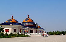
Ordos Museum[]

In 2011, a 49,400-square-meter museum, entitled Ordos Museum (Chinese: 鄂尔多斯博物馆), was opened in Kangbashi. The museum, designed by China-based architectural practice MAD Studio, focuses upon the history of the Ordos area, as well as on the culture and traditions of Inner Mongolia.[16]
Transportation[]
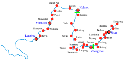
Travel within Ordos City is primarily made by car or bus, using the city's network roads. Two tolled expressways, the G18 Rongcheng–Wuhai Expressway and the G65 Baotou–Maoming Expressway, provide connections with other towns and cities including Dongsheng.
In 2016, the Ordos railway station in the city opened. The station is on the Beijing-Baotou railway, the Hohhot-Ordos high-speed railway line, and the Baotou-West railway. High speed trains to the provincial capital of Hohhot are run on a daily basis.[17] As well as slower speed trains directly to and from Beijing West railway station.[18]
Ordos Ejin Horo Airport is located in Ejin Horo Banner.
Demographics[]
In the 2000 census, there were 1,369,766 inhabitants:
| ethnic group | population | share |
|---|---|---|
| Han | 1,207,971 | 88.19% |
| Mongols | 155,845 | 11.38% |
| Manchu | 2,905 | 0.21% |
| Hui | 1,861 | 0.14% |
| Tibetans | 1,023 | 0.07% |
Many people came from the Shanxi province, 30 km (19 mi) south of this city.[citation needed]
See also[]
- Ordos culture
- Ordos International Circuit
- Mausoleum of Genghis Khan
- List of cities in China by population
- List of cities in China by GDP per capita
- Under-occupied developments in China
References[]
- ^ Jump up to: a b Ministry of Housing and Urban-Rural Development, ed. (2019). China Urban Construction Statistical Yearbook 2017. Beijing: China Statistics Press. p. 46. Retrieved 11 January 2020.
- ^ https://www.citypopulation.de/en/china/neimenggu/admin/
- ^ Sheehan, Matt (5 April 2015). "Signs of Life In China's Gleaming 'Ghost City' Of Ordos". Huffington Post. Retrieved 17 July 2018.
- ^ Shepard, Wade. "China's Most Infamous 'Ghost City' Is Rising From The Desert". Forbes. Retrieved 2018-08-24.
- ^ 市情概况. Archived from the original on 2009-11-22. Retrieved 2009-11-13.
- ^ G. John Ramstedt: Kalmückisches Wörterbuch, Helsinki, 1935, Suomalais-Ugrilainen Seura, and Ferdinand D. Lessing, ed.: Mongolian-English Dictionary, Bloomington, Ind., 1982, The Mongolia Society, Inc.
- ^ W. R. Carles, "Problems in Exploration II. Ordos", in The Geographical Journal, Vol. 33, No. 6 (Jun., 1909), p. 669
- ^ Jump up to: a b c Weather China
- ^ Woodworth, Max David. Frontier Boomtown Urbanism: City Building in Ordos Municipality, Inner Mongolia Autonomous Region, 2001-2011 (PDF). p. 51.
- ^ Wong, Joon Ian. "Photos: Inside one of the world's largest bitcoin mines". Quartz. Retrieved 31 August 2017.
- ^ Gertz, Bill. "EXCLUSIVE: China building third missile field for hundreds of new ICBMs". The Washington Times. The Washington Times. Retrieved 25 August 2021.
- ^ Time Photos of Ordos/Kangbashi, Time Photos Website 2011
- ^ Gus Lubin (2011-06-13). "NEW SATELLITE PICTURES OF CHINA'S GHOST CITIES". Business Insider. Retrieved 2011-12-09.
- ^ Barboza, David (2010-10-19). "A New Chinese City, With Everything but People". New York Times.
- ^ "China's Ghost Town". AlJazeera. 10 November 2009. Retrieved 2010-12-21.
- ^ "Ordos Museum". WikiArchitectura. Retrieved 2017-01-25.
- ^ https://www.sohu.com/a/72526111_412307
- ^ http://search.huochepiao.com/shike_eerduosi_beijingxi
External links[]
| Wikivoyage has a travel guide for Ordos City. |
| show Inner Mongolia topics |
|---|
| show Major cities along the Yellow River |
|---|
| show Authority control |
|---|
- Ordos City
- Cities in Inner Mongolia
- Prefecture-level divisions of Inner Mongolia
- Socialist planned cities