Chroboly
Chroboly | |
|---|---|
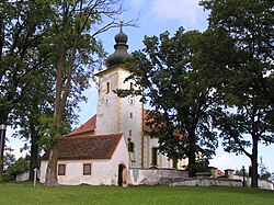 Church of the Nativity of the Virgin Mary | |
 Flag  Coat of arms | |
 Chroboly Location in the Czech Republic | |
| Coordinates: 48°57′24″N 14°4′1″E / 48.95667°N 14.06694°ECoordinates: 48°57′24″N 14°4′1″E / 48.95667°N 14.06694°E | |
| Country | |
| Region | South Bohemian |
| District | Prachatice |
| First mentioned | 1317 |
| Area | |
| • Total | 34.68 km2 (13.39 sq mi) |
| Elevation | 758 m (2,487 ft) |
| Population (2021-01-01)[1] | |
| • Total | 570 |
| • Density | 16/km2 (43/sq mi) |
| Time zone | UTC+1 (CET) |
| • Summer (DST) | UTC+2 (CEST) |
| Postal codes | 383 01, 384 04 |
| Website | www |

Chroboly (German: Chrobold) is a municipality and village in Prachatice District in the South Bohemian Region of the Czech Republic. It has about 600 inhabitants.
Chroboly lies approximately 9 kilometres (6 mi) south-east of Prachatice, 31 km (19 mi) west of České Budějovice, and 129 km (80 mi) south of Prague.
Administrative parts[]
Villages of Leptač, Lučenice, Ovesné, Příslop, Rohanov and Záhoří are administrative parts of Chroboly.
References[]
| Wikimedia Commons has media related to Chroboly. |
| Authority control: National libraries |
|---|
This South Bohemian Region location article is a stub. You can help Wikipedia by . |
Categories:
- Villages in Prachatice District
- Bohemian Forest
- South Bohemian Region geography stubs