Kubova Huť
Kubova Huť | |
|---|---|
Municipality | |
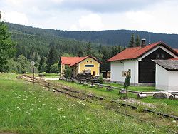 Train station | |
 Flag  Coat of arms | |
 Kubova Huť | |
| Coordinates: 48°58′50″N 13°46′23″E / 48.98056°N 13.77306°ECoordinates: 48°58′50″N 13°46′23″E / 48.98056°N 13.77306°E | |
| Country | |
| Region | South Bohemian |
| District | Prachatice |
| Area | |
| • Total | 1.41 km2 (0.54 sq mi) |
| Elevation | 960 m (3,150 ft) |
| Population (2006) | |
| • Total | 96 |
| • Density | 68/km2 (180/sq mi) |
| Postal code | 385 01 |
| Website | http://www.kubova-hut.cz |

Kubova Huť (German: Kubohütten) is a village and municipality (obec) in Prachatice District in the South Bohemian Region of the Czech Republic.
The municipality covers an area of 1.41 square kilometres (0.54 sq mi), and has a population of 96 (as at 3 July 2006).
Kubova Huť lies approximately 17 kilometres (11 mi) west of Prachatice, 52 km (32 mi) west of České Budějovice, and 132 km (82 mi) south of Prague. Its railway station is the highest in the Czech Republic, at 995 m (3,264 ft) above sea level.[1]
References[]
| Wikimedia Commons has media related to Kubova Huť. |
| Authority control: National libraries |
|---|
This South Bohemian Region location article is a stub. You can help Wikipedia by . |
Categories:
- Villages in Prachatice District
- Bohemian Forest
- South Bohemian Region geography stubs