Chropov
Some of this article's listed sources may not be reliable. (December 2013) |
Chropov | |
|---|---|
Municipality | |
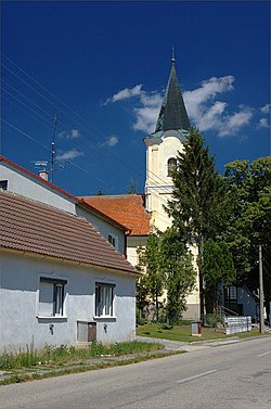 Church of Saint John of Nepomuk | |
 Chropov Location of Chropov in the Trnava Region | |
| Coordinates: 48°46′N 17°19′E / 48.767°N 17.317°ECoordinates: 48°46′N 17°19′E / 48.767°N 17.317°E | |
| Country | Slovakia |
| Region | Trnava |
| District | Skalica |
| First mentioned | 1262 |
| Area | |
| • Total | 17.794 km2 (6.870 sq mi) |
| Elevation | 246 m (807 ft) |
| Population | |
| • Total | 355 |
| • Density | 20/km2 (52/sq mi) |
| Time zone | UTC+1 (CET) |
| • Summer (DST) | UTC+2 (CEST) |
| Postal code | 908 64 |
| Area code(s) | 421-34 |
| Car plate | SI |
| Website | chropov.sk |


Chropov is a village and municipality in Skalica District in the Trnava Region of western Slovakia.
History[]
In historical records the village was first mentioned in 1262.
Geography[]
The municipality lies at an altitude of 246 metres and covers an area of 17.794 km². It has a population of about 355 people.
Genealogical resources[]
The records for genealogical research are available at the state archive "Statny Archiv in Bratislava, Slovakia"
- Roman Catholic church records (births/marriages/deaths): 1635-1927 (parish A)
See also[]
External links[]
![]() Media related to Chropov at Wikimedia Commons
Media related to Chropov at Wikimedia Commons
Municipalities of Skalica District | ||
|---|---|---|
This Trnava Region geography article is a stub. You can help Wikipedia by . |
Categories:
- Villages and municipalities in Skalica District
- Trnava Region geography stubs