Chumerna Glacier
This article includes a list of references, related reading or external links, but its sources remain unclear because it lacks inline citations. Please help to improve this article by introducing more precise citations. (May 2021) (Learn how and when to remove this template message) |
| Chumerna Glacier | |
|---|---|
 Location of Brabant Island in the Antarctic Peninsula region | |
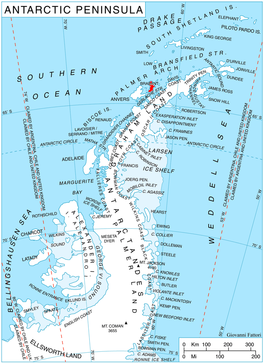
 Location of Chumernan Glacier in Antarctica | |
| Location | Palmer Archipelago |
| Coordinates | 64°08′10″S 62°06′20″W / 64.13611°S 62.10556°W / -64.13611; -62.10556 |
| Length | 1.1 nmi (2 km; 1 mi) |
| Width | 1 nmi (2 km; 1 mi) |
| Thickness | unknown |
| Terminus | east of Hales Peak |
| Status | unknown |
Chumerna Glacier (Bulgarian: ледник Чумерна, romanized: lednik Chumerna, IPA: [ˈlɛdnik t͡ʃoˈmɛrnɐ]) is the 2.2 km long and 1.9 km wide glacier draining the north slopes of Stavertsi Ridge on Albena Peninsula, Brabant Island in the Palmer Archipelago, Antarctica. It flows northeastwards to enter the channel between Brabant Island and Liège Island east of Hales Peak.
The glacier is named after in eastern Balkan Mountains, Bulgaria.
Location[]
Chumerna Glacier is centred at 64°08′10″S 62°06′20″W / 64.13611°S 62.10556°W / -64.13611; -62.10556Coordinates: 64°08′10″S 62°06′20″W / 64.13611°S 62.10556°W / -64.13611; -62.10556. British mapping in 1980.
See also[]
- List of glaciers in the Antarctic
- Glaciology
Maps[]
- Antarctic Digital Database (ADD). Scale 1:250000 topographic map of Antarctica. Scientific Committee on Antarctic Research (SCAR). Since 1993, regularly upgraded and updated.
- British Antarctic Territory. Scale 1:200000 topographic map. DOS 610 Series, Sheet W 64 62. Directorate of Overseas Surveys, Tolworth, UK, 1980.
- Brabant Island to Argentine Islands. Scale 1:250000 topographic map. British Antarctic Survey, 2008.
References[]
- Bulgarian Antarctic Gazetteer. Antarctic Place-names Commission. (details in Bulgarian, basic data in English)
- Chumerna Glacier. SCAR Composite Antarctic Gazetteer
External links[]
- Chumerna Glacier. Copernix satellite image
This article includes information from the Antarctic Place-names Commission of Bulgaria which is used with permission.

Glaciers | |||||||
|---|---|---|---|---|---|---|---|
| Types |
| ||||||
| Anatomy |
| ||||||
| Processes |
| ||||||
| Measurements |
| ||||||
| Volcanic relations | |||||||
| Landforms |
| ||||||
| |||||||
Glaciers in the Antarctic | |
|---|---|
|
Glaciers of the Palmer Archipelago Graham Land | |
|---|---|
| Palmer Archipelago |
|
| Adelaide Island |
|
| Antarctic Peninsula |
|
| James Ross Island |
|
| Trinity Peninsula |
|
This Brabant Island location article is a stub. You can help Wikipedia by . |
- v
- t
This article about a glacier in the Palmer Archipelago is a stub. You can help Wikipedia by . |
- v
- t
- Glaciers of the Palmer Archipelago
- Bulgaria and the Antarctic
- Brabant Island
- Brabant Island geography stubs
- Graham Land glacier stubs
- Palmer Archipelago geography stubs
- Articles with short description
- Short description matches Wikidata
- Articles lacking in-text citations from May 2021
- All articles lacking in-text citations
- Articles containing Bulgarian-language text
- Coordinates on Wikidata
- All stub articles