Cimarron, Colorado
Cimarron, Colorado | |
|---|---|
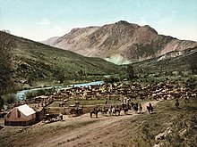
 In 1883 | |
 Cimarron, Colorado Location within the state of Colorado | |
| Coordinates: 38°26′30″N 107°33′22″W / 38.44167°N 107.55611°WCoordinates: 38°26′30″N 107°33′22″W / 38.44167°N 107.55611°W | |
| Country | |
| State | |
| County | Montrose County |
| Elevation | 2,102 m (6,896 ft) |
| Time zone | UTC-7 (MST) |
| • Summer (DST) | UTC-6 (MDT) |
| ZIP Code | 81220[2] |

Cimarron is an unincorporated rural hamlet in Montrose County, Colorado, United States. It is located on the northern side of U.S. Highway 50, 19 miles from the town of Montrose to its west, and 42 miles from Gunnison, Colorado Gunnison to its east. There is a store with fuel pumps and a post office at Cimarron. The post office services the rural ZIP Code 81220 area.[2]
Cimarron is located along the Cimarron River, just south of the Black Canyon of the Gunnison, and just outside Curecanti National Recreation Area. The D & RG Narrow Gauge Trestle crosses the Cimarron River gorge just northeast of town, and is on the National Register of Historic Places (#76000172).
Geography[]
Cimarron is located at 38°26′30″N 107°33′22″W / 38.44167°N 107.55611°W (38.441758,-107.555981).
See also[]
- Outline of Colorado
- State of Colorado
- Colorado cities and towns
- Colorado counties
- Colorado metropolitan areas
- Montrose, CO Micropolitan Statistical Area
- Black Canyon of the Gunnison National Park
- Cimarron River
- Curecanti National Recreation Area
- D & RG Narrow Gauge Trestle
- Morrow Point Dam
References[]
- ^ "US Board on Geographic Names". United States Geological Survey. 2007-10-25. Retrieved 2008-01-31.
- ^ Jump up to: a b "ZIP Code Lookup". United States Postal Service. December 15, 2006. Archived from the original (JavaScript/HTML) on September 3, 2007. Retrieved December 15, 2006.
| show Municipalities and communities of Montrose County, Colorado, United States |
|---|

| show Authority control |
|---|
- Unincorporated communities in Montrose County, Colorado
- Gunnison River
- Curecanti National Recreation Area
- Unincorporated communities in Colorado