Clarence Cannon National Wildlife Refuge
| Clarence Cannon National Wildlife Refuge | |
|---|---|
IUCN category IV (habitat/species management area) | |
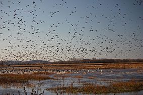 Fall migration, Clarence Cannon National Wildlife Refuge, November 2011 | |
 Map of the United States | |
| Location | Pike County, Missouri, United States |
| Nearest city | Annada, Missouri |
| Coordinates | 39°16′01″N 90°47′02″W / 39.267°N 90.784°W[1]Coordinates: 39°16′01″N 90°47′02″W / 39.267°N 90.784°W[1] |
| Area | 3,750 acres (15.2 km2) |
| Established | 1964 |
| Governing body | U.S. Fish and Wildlife Service |
| Website | Clarence Cannon National Wildlife Refuge |


The 3,750-acre (15.2 km2) Clarence Cannon National Wildlife Refuge is located in the floodplain of the Mississippi River, adjacent to Pool No. 25 in Pike County, Missouri. The refuge's diversity of habitats supports waterfowl, wading birds, shorebirds, and songbirds. Although it is protected by a levee, the refuge provides flood storage in periods of high water.
Clarence Cannon Refuge is managed by Great River National Wildlife Refuge, which is part of the Mark Twain National Wildlife Refuge Complex.
See also[]
References[]
![]() This article incorporates public domain material from websites or documents of the United States Fish and Wildlife Service.
This article incorporates public domain material from websites or documents of the United States Fish and Wildlife Service.
External links[]
 Media related to Clarence Cannon National Wildlife Refuge at Wikimedia Commons
Categories:
- IUCN Category IV
- National Wildlife Refuges in Missouri
- Protected areas on the Mississippi River
- Protected areas of Pike County, Missouri
- Floodplains of the United States
- Wetlands of Missouri
- Landforms of Pike County, Missouri
- Protected areas established in 1964
- 1964 establishments in Missouri