Table Rock State Park (Missouri)
| Table Rock State Park | |
|---|---|
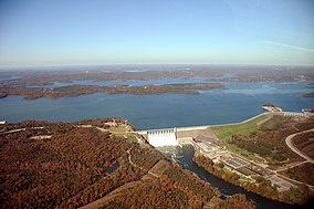 Table Rock Lake and Dam with state park in left foreground | |
 Location in Missouri | |
| Location | Taney, Stone, Missouri, United States |
| Coordinates | 36°35′15″N 93°18′37″W / 36.58750°N 93.31028°WCoordinates: 36°35′15″N 93°18′37″W / 36.58750°N 93.31028°W[1] |
| Area | 356.03 acres (144.08 ha)[2] |
| Elevation | 889 ft (271 m)[1] |
| Established | 1959 |
| Governing body | Missouri Department of Natural Resources |
| Website | Table Rock Mountain State Park |


Table Rock State Park is a public recreation area in the U.S. state of Missouri consisting of 356 acres (144 ha) located in Taney County and Stone County on Table Rock Lake along the southern side of the city of Branson. The state park's facilities include a marina, campgrounds, and trails for hiking and bicycling.[3]
References[]
- ^ Jump up to: a b "Table Rock State Park". Geographic Names Information System. United States Geological Survey.
- ^ "State parks...estimated acres" (PDF). Revised Statewide Comprehensive Outdoor Recreation Plan: 2008-2012. Missouri Department of Natural Resources. pp. 142–143. Retrieved April 13, 2018.
- ^ "Table Rock State Park". Missouri State Parks. Missouri Department of Natural Resources. Retrieved September 8, 2014.
External links[]
- Table Rock State Park Missouri Department of Natural Resources
- Table Rock State Park Map Missouri Department of Natural Resources
| Authority control |
|
|---|
Categories:
- State parks of Missouri
- State parks of the U.S. Interior Highlands
- Protected areas of Stone County, Missouri
- Protected areas established in 1959
- Protected areas of Taney County, Missouri