Clarendon County, New South Wales

From Wikipedia, the free encyclopedia

Map all coordinates using: OpenStreetMap 
Download coordinates as: KML
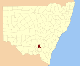
Clarendon
New South Wales
Clarendon NSW.PNG
Location in New South Wales
Lands administrative divisions around Clarendon:
Bourke Bland Bland
Bourke Clarendon Harden
Mitchell Wynyard Buccleuch

Clarendon County is one of the 141 Cadastral divisions of New South Wales. It contains the towns of Gundagai, Junee and Bethungra. The Murrumbidgee River is the boundary to the south.

Clarendon County was named in honour of George William Frederick Villiers, 4th Earl Clarendon (1800-1870).[1]

The Murrumbidgee River at Gundagai; the boundary between Clarendon and Wynyard

Parishes within this county[]

A full list of parishes found within this county; their current LGA and mapping coordinates to the approximate centre of each location is as follows:

Parish LGA Coordinates
Bethungra Junee Shire Council 34°43′54″S 147°50′04″E / 34.73167°S 147.83444°E / -34.73167; 147.83444 (Bethungra)
Junee Shire Council 35°04′54″S 147°39′04″E / 35.08167°S 147.65111°E / -35.08167; 147.65111 (Bilda)
Junee Shire Council 34°47′54″S 147°48′04″E / 34.79833°S 147.80111°E / -34.79833; 147.80111 (Billabung)
Boree Junee Shire Council 34°50′54″S 147°39′04″E / 34.84833°S 147.65111°E / -34.84833; 147.65111 (Boree)
City of Wagga Wagga 34°57′54″S 147°20′04″E / 34.96500°S 147.33444°E / -34.96500; 147.33444 (Bulgan)
Junee Shire Council 34°35′54″S 147°46′04″E / 34.59833°S 147.76778°E / -34.59833; 147.76778 (Bute)
Junee Shire Council 34°59′54″S 147°40′04″E / 34.99833°S 147.66778°E / -34.99833; 147.66778 (Claris)
Junee Shire Council 34°55′54″S 147°52′04″E / 34.93167°S 147.86778°E / -34.93167; 147.86778 (Cooba)
Eunanoreenya City of Wagga Wagga 35°03′54″S 147°29′04″E / 35.06500°S 147.48444°E / -35.06500; 147.48444 (Eunanoreenya)
Eurongilly Junee Shire Council 34°55′54″S 147°45′04″E / 34.93167°S 147.75111°E / -34.93167; 147.75111 (Eurongilly)
Gobbagombalin City of Wagga Wagga 35°02′54″S 147°18′04″E / 35.04833°S 147.30111°E / -35.04833; 147.30111 (Gobbagombalin)
Junee Shire Council 34°47′54″S 147°30′04″E / 34.79833°S 147.50111°E / -34.79833; 147.50111 (Gwynne)
Junee Shire Council 34°43′40″S 147°32′43″E / 34.72778°S 147.54528°E / -34.72778; 147.54528 (Houlaghan)
Junee Shire Council 34°36′54″S 147°41′04″E / 34.61500°S 147.68444°E / -34.61500; 147.68444 (Hurley)
Junee Shire Council 34°44′54″S 147°45′04″E / 34.74833°S 147.75111°E / -34.74833; 147.75111 (Ironbong)
Junee Shire Council 34°44′54″S 147°40′04″E / 34.74833°S 147.66778°E / -34.74833; 147.66778 (Ivor)
Junee Shire Council 34°59′54″S 147°35′04″E / 34.99833°S 147.58444°E / -34.99833; 147.58444 (Jeralgambeth)
Junee Junee Shire Council 34°47′54″S 147°33′04″E / 34.79833°S 147.55111°E / -34.79833; 147.55111 (Junee)
Cootamundra-Gundagai Regional Council 35°02′54″S 148°00′04��E / 35.04833°S 148.00111°E / -35.04833; 148.00111 (Kimo)
Malebo Junee Shire Council 34°55′54″S 147°23′04″E / 34.93167°S 147.38444°E / -34.93167; 147.38444 (Malebo)
Junee Shire Council 34°50′54″S 147°28′04″E / 34.84833°S 147.46778°E / -34.84833; 147.46778 (Maror)
Junee Shire Council 34°51′54″S 147°48′04″E / 34.86500°S 147.80111°E / -34.86500; 147.80111 (Merrybundinah)
Mitta Mitta Junee Shire Council 34°51′54″S 147°54′04″E / 34.86500°S 147.90111°E / -34.86500; 147.90111 (Mitta Mitta)
Nangus Cootamundra-Gundagai Regional Council 35°00′54″S 147°57′04″E / 35.01500°S 147.95111°E / -35.01500; 147.95111 (Nangus)
Cootamundra-Gundagai Regional Council 35°00′54″S 148°04′04″E / 35.01500°S 148.06778°E / -35.01500; 148.06778 (North Gundagai)
North Wagga Wagga City of Wagga Wagga 35°03′54″S 147°23′04″E / 35.06500°S 147.38444°E / -35.06500; 147.38444 (North Wagga Wagga)
Oura City of Wagga Wagga 35°03′54″S 147°33′04″E / 35.06500°S 147.55111°E / -35.06500; 147.55111 (Oura)
Sebastopol Temora Shire Council 34°35′54″S 147°34′04″E / 34.59833°S 147.56778°E / -34.59833; 147.56778 (Sebastopol)
Junee Shire Council 34°53′54″S 147°31′04″E / 34.89833°S 147.51778°E / -34.89833; 147.51778 (South Junee)
Tenandra Junee Shire Council 34°59′54″S 147°50′04″E / 34.99833°S 147.83444°E / -34.99833; 147.83444 (Tenandra)
Junee Shire Council 34°40′54″S 147°40′04″E / 34.68167°S 147.66778°E / -34.68167; 147.66778 (Trevethin)
Ulandra Junee Shire Council 34°45′54″S 147°54′04″E / 34.76500°S 147.90111°E / -34.76500; 147.90111 (Ulandra)
City of Wagga Wagga 34°57′54″S 147°28′04″E / 34.96500°S 147.46778°E / -34.96500; 147.46778 (Wallace)
Wantabadgery Junee Shire Council 34°59′54″S 147°45′04″E / 34.99833°S 147.75111°E / -34.99833; 147.75111 (Wantabadgery)
Junee Shire Council 34°54′54″S 147°39′04″E / 34.91500°S 147.65111°E / -34.91500; 147.65111 (Wantiool)
Junee Shire Council 34°38′54″S 147°32′04″E / 34.64833°S 147.53444°E / -34.64833; 147.53444 (Warre Warral)

References[]

  1. ^ "Clarendon County". Geographical Names Register (GNR) of NSW. Geographical Names Board of New South Wales. Edit this at Wikidata
Retrieved from ""