Mitchell County, New South Wales

From Wikipedia, the free encyclopedia

Map all coordinates using: OpenStreetMap 
Download coordinates as: KML
Mitchell
New South Wales
Mitchell NSW.PNG
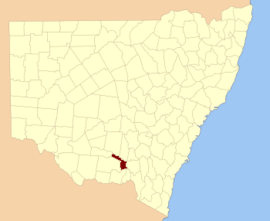
Location in New South Wales
Lands administrative divisions around Mitchell:
Cooper Bourke Clarendon
Urana Mitchell Wynyard
Urana Hume Goulburn

Mitchell County is one of the 141 Cadastral divisions of New South Wales. It contains the town of Collingullie. The Murrumbidgee River is the northern boundary.

Mitchell County is named in honour of the Surveyor-General Sir Thomas Livingstone Mitchell (1792-1855).[1]

Parishes within this county[]

A full list of parishes found within this county; their current LGA and mapping coordinates to the approximate centre of each location is as follows:

Parish LGA Coordinates
City of Wagga Wagga 35°01′54″S 146°50′04″E / 35.03167°S 146.83444°E / -35.03167; 146.83444 (Arajoel)
Lockhart Shire Council 35°13′54″S 146°53′04″E / 35.23167°S 146.88444°E / -35.23167; 146.88444 (Ashcroft)
City of Wagga Wagga 35°02′54″S 147°00′04″E / 35.04833°S 147.00111°E / -35.04833; 147.00111 (Berry Jerry)
Narrandera Shire Council 34°56′54″S 146°35′04″E / 34.94833°S 146.58444°E / -34.94833; 146.58444 (Birrego)
Narrandera Shire Council 34°51′54″S 146°45′04″E / 34.86500°S 146.75111°E / -34.86500; 146.75111 (Brewarrena)
Narrandera Shire Council 34°51′54″S 146°41′04″E / 34.86500°S 146.68444°E / -34.86500; 146.68444 (Buckinbong)
City of Wagga Wagga 35°00′54″S 146°57′04″E / 35.01500°S 146.95111°E / -35.01500; 146.95111 (Bulgary)
Lockhart Shire Council 35°07′54″S 147°00′04″E / 35.13167°S 147.00111°E / -35.13167; 147.00111 (Bullenbung)
Lockhart Shire Council 35°17′54″S 147°10′04″E / 35.29833°S 147.16778°E / -35.29833; 147.16778 (Burke)
Burrandana City of Wagga Wagga 35°23′54″S 147°22′04″E / 35.39833°S 147.36778°E / -35.39833; 147.36778 (Burrandana)
City of Wagga Wagga 35°21′54″S 147°18′04″E / 35.36500°S 147.30111°E / -35.36500; 147.30111 (Coffin Rock)
Corobimilla Narrandera Shire Council 34°52′54″S 146°23′04″E / 34.88167°S 146.38444°E / -34.88167; 146.38444 (Corobimilla)
Lockhart Shire Council 35°22′54″S 147°08′04″E / 35.38167°S 147.13444°E / -35.38167; 147.13444 (Cox)
Narrandera Shire Council 34°48′54″S 146°24′04″E / 34.81500°S 146.40111°E / -34.81500; 146.40111 (Cuddell)
Lockhart Shire Council 35°28′54″S 147°01′04″E / 35.48167°S 147.01778°E / -35.48167; 147.01778 (Edgehill)
Narrandera Shire Council 34°57′54″S 146°41′04″E / 34.96500°S 146.68444°E / -34.96500; 146.68444 (Faithfull)
Narrandera Shire Council 34°44′54″S 146°30′04″E / 34.74833°S 146.50111°E / -34.74833; 146.50111 (Gillenbah)
Narrandera Shire Council 34°51′54″S 146°36′04″E / 34.86500°S 146.60111°E / -34.86500; 146.60111 (Gobbagaula)
Lockhart Shire Council 35°24′54″S 147°00′04″E / 35.41500°S 147.00111°E / -35.41500; 147.00111 (Grubben)
Lockhart Shire Council 35°15′54″S 147°03′04″E / 35.26500°S 147.05111°E / -35.26500; 147.05111 (Hanging Rock)
Lockhart Shire Council 35°14′54″S 147°07′04″E / 35.24833°S 147.11778°E / -35.24833; 147.11778 (Leitch)
City of Wagga Wagga 35°26′54″S 147°15′04″E / 35.44833°S 147.25111°E / -35.44833; 147.25111 (Maclean)
Mangoplah City of Wagga Wagga 35°22′54″S 147°15′04″E / 35.38167°S 147.25111°E / -35.38167; 147.25111 (Mangoplah)
Milbrulong Lockhart Shire Council 35°18′54″S 146°55′04″E / 35.31500°S 146.91778°E / -35.31500; 146.91778 (Milbrulong)
Narrandera Shire Council 35°00′54″S 146°46′04″E / 35.01500°S 146.76778°E / -35.01500; 146.76778 (Mimosa)
Lockhart Shire Council 35°23′54″S 146°53′04″E / 35.39833°S 146.88444°E / -35.39833; 146.88444 (Mundawaddery)
City of Wagga Wagga 35°06′54″S 147°06′04″E / 35.11500°S 147.10111°E / -35.11500; 147.10111 (Mundowy)
City of Wagga Wagga 35°07′54″S 146°54′04″E / 35.13167°S 146.90111°E / -35.13167; 146.90111 (Osborne)
City of Wagga Wagga 35°15′54″S 147°11′04″E / 35.26500°S 147.18444°E / -35.26500; 147.18444 (Pearson)
Pulletop City of Wagga Wagga 35°26′54″S 147°22′04″E / 35.44833°S 147.36778°E / -35.44833; 147.36778 (Pulletop)
City of Wagga Wagga 35°15′54″S 147°18′04″E / 35.26500°S 147.30111°E / -35.26500; 147.30111 (Sandy Creek)
Tootool Lockhart Shire Council 35°14′54″S 147°00′04″E / 35.24833°S 147.00111°E / -35.24833; 147.00111 (Tootool)
Uranquinty City of Wagga Wagga 35°06′54″S 147°15′04″E / 35.11500°S 147.25111°E / -35.11500; 147.25111 (Uranquinty)
Lockhart Shire Council 35°20′54″S 147°00′04″E / 35.34833°S 147.00111°E / -35.34833; 147.00111 (Vincent)
City of Wagga Wagga 34°56′54″S 146°51′04″E / 34.94833°S 146.85111°E / -34.94833; 146.85111 (Wauberrima)
Westby City of Wagga Wagga 35°26′54″S 147°27′04″E / 35.44833°S 147.45111°E / -35.44833; 147.45111 (Westby)
Narrandera Shire Council 34°52′54″S 146°30′04″E / 34.88167°S 146.50111°E / -34.88167; 146.50111 (Wood)
Narrandera Shire Council 34°44′54″S 146°26′04″E / 34.74833°S 146.43444°E / -34.74833; 146.43444 (Yarabee)
City of Wagga Wagga 35°08′54″S 147°12′04″E / 35.14833°S 147.20111°E / -35.14833; 147.20111 (Yarragundry)
Lockhart Shire Council 35°24′54″S 147°05′04″E / 35.41500°S 147.08444°E / -35.41500; 147.08444 (Yerong)

References[]

  1. ^ "Mitchell County". Geographical Names Register (GNR) of NSW. Geographical Names Board of New South Wales. Edit this at Wikidata
Retrieved from ""