Clark's Harbour
Clark's Harbour | |
|---|---|
Town | |
 | |
| Motto(s): Unity with Independence | |
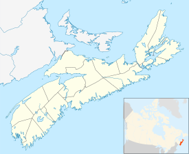 Clark's Harbour Location of Clark's Harbour, Nova Scotia | |
| Coordinates: 43°26′33″N 65°37′44″W / 43.4425°N 65.628889°W[1] | |
| Country | |
| Province | |
| County | Shelburne |
| Municipal district | Barrington |
| Founded | 1773 |
| Incorporated | March 4, 1919 |
| Government | |
| • Type | Town Council |
| • Mayor | Rex Stoddard |
| Area (2016)[2] | |
| • Land | 2.81 km2 (1.08 sq mi) |
| Elevation | 2 m (7 ft) |
| Population (2016)[2] | |
| • Total | 758 |
| • Density | 269.6/km2 (698/sq mi) |
| • Change (2011-16) | |
| • Dwellings | 407 |
| Time zone | UTC-4 (AST) |
| • Summer (DST) | UTC-3 (ADT) |
| Postal code(s) | B0W 1P0 |
| Area code(s) | 902 (745) |
| Access Routes | |
| Website | clarksharbour.com |

Clark's Harbour is a town on Cape Sable Island in southwestern Nova Scotia, Canada, located in the Municipality of the District of Barrington in Shelburne County.[3] The main industry is lobster fishing. Owing to this as well as the town's history as a fishing community, the town is noted as the birthplace of the Cape Islander fishing boat.
The community is the southernmost town in the province of Nova Scotia, and thus one of the southernmost towns in Canada, being located roughly on a parallel with Bilbao, Spain and just north of Rome.
Demographics[]
| Year | Pop. | ±% |
|---|---|---|
| 1941 | 887 | — |
| 1951 | 1,020 | +15.0% |
| 1981 | 1,059 | +3.8% |
| 1986 | 1,098 | +3.7% |
| 1991 | 1,076 | −2.0% |
| 1996 | 980 | −8.9% |
| 2001 | 944 | −3.7% |
| 2006 | 860 | −8.9% |
| 2011 | 820 | −4.7% |
| 2016 | 758 | −7.6% |
| [4] | ||
In the 2016 Census of Population conducted by Statistics Canada, the Town of Clark's Harbour recorded a population of 758 living in 361 of its 407 total private dwellings, a change of -7.6% from its 2011 population of 820. With a land area of 2.81 km2 (1.08 sq mi), it had a population density of 269.8/km2 (698.7/sq mi) in 2016.[2]
|
Mother tongue language (2006)[5]
|
|
|
Religious make-up (2001)[7]
|
Income (2006)[5]
|
Climate[]
Clark's Harbour has an oceanic climate (Köppen climate classification Cfb) with milder winters than the mainland. The town has a significant seasonal lag, with September having the warmest year-round lows, as well as having warmer weather in the daytime compared to July.
Economy[]
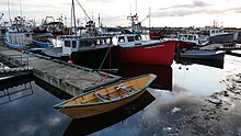
The economy of Clark's Harbour and its surrounding areas is driven largely by the fishing industry and in particular the seasonal lobster fishery. Shelburne County (in which Clark's Harbour is located) is generally accepted as the lobster capital of Nova Scotia (and a nearby sign boasts the claim that it is the Lobster Capital of Canada). The fishery has also given rise to various secondary and tertiary industries such as further seafood processing and packaging, and boatbuilding. Lobster that is trapped by Clark's Harbour fishers is exported around the world, but primarily to the New England market.
There are several other employers in Clark's Harbour, including a general store, a bank, a service station, a pizza parlor, and a takeout restaurant. However, the economic impact of these businesses is generally small compared to the fishery.
Public library[]

Located at 2648 Main Street in Clark's Harbour, the Clark's Harbour Branch Library is one of the 10 branches of Western Counties Regional Library. It joined the Western Counties Regional Library in July 1971 but it did not have a physical location in Clark's Harbour until the first branch opened on March 4, 1974 . The branch was relocated to its present site as part of the Clark's Harbour Civic Centre on December 11, 2007.[8]
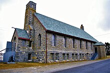
Stone Church[]
One of the more notable attractions in Clark's Harbour is the United Baptist Stone Church, which is a popular destination for visitors. It is noted primarily for its unique architecture,
The Stone Church was first started on September 5, 1921, by Lieutenant-Governor MacCallum Grant. The foundation is made of native granite, and three feet in thickness. The granite that was used was all cut by hand using chisels. The walls are made of cobblestones gathered from the shore and surrounding islands. This church is eighty-five feet by fifty-five feet and has a seating capacity of five hundred. The inside of the church is decorated in rich wood, and the windows are stained glass.
Thomas Doucette was given the task of constructing the Stone Church from blueprints. The blueprints were designed by a Halifax architect named S.P. Dumaresq. Doucette began building the church, even though he could not read or write and had the blueprints read to him only once. It took ten years to complete the erection of the church.
See also[]
References[]
- ^ Nova Scotia Geographical Names: Clark's Harbour[permanent dead link]
- ^ Jump up to: a b c "Population and dwelling counts, for Canada, provinces and territories, and census subdivisions (municipalities), 2016 and 2011 censuses – 100% data (Nova Scotia)". Statistics Canada. February 8, 2017. Retrieved February 12, 2017.
- ^ Government of Nova Scotia website: Community Counts
- ^ "I:\ecstats\Agency\BRIAN\census2" (PDF). Archived from the original (PDF) on 2013-10-05. Retrieved 2012-12-26.
- ^ Jump up to: a b 2006 Statistics Canada Community Profile: Clark's Harbour, Nova Scotia
- ^ 2006 Statistics Canada Census
- ^ Statistics Canada Religious make-up, for Yarmouth, 2001 census - 100% data
- ^ WCRL – Clark's Harbour Branch Library. Retrieved August 12, 2010.
External links[]
| show Places adjacent to Clark's Harbour |
|---|
Coordinates: 43°26′33″N 65°37′44″W / 43.44250°N 65.62889°W
| Authority control |
|
|---|
- Communities in Shelburne County, Nova Scotia
- Towns in Nova Scotia
- General Service Areas in Nova Scotia
- Populated coastal places in Canada
- 1773 establishments in the British Empire