Truro, Nova Scotia
Truro
Gaelic: Truru | |
|---|---|
Town | |
 Flag  Seal | |
| Nickname(s): Hub of Nova Scotia | |
| Motto(s): Begun In Faith, Continued In Determination | |
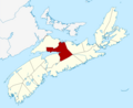
 Truro Location within Nova Scotia | |
| Coordinates: 45°21′53″N 63°16′48″W / 45.36472°N 63.28000°WCoordinates: 45°21′53″N 63°16′48″W / 45.36472°N 63.28000°W | |
| Country | Canada |
| Province | Nova Scotia |
| County | Colchester |
| Founded | 1759 |
| Incorporated | May 6, 1875 |
| Government | |
| • Body | Truro Town Council |
| • Mayor | W.R. (Bill) Mills |
| • MLA | Dave Ritcey (PC) |
| • MP | Lenore Zann (L) |
| Area (2016)[1] | |
| • Total | 34.49 km2 (13.32 sq mi) |
| Elevation | 19 m (62 ft) |
| Population | |
| • Total | 12,261 |
| • Density | 355.5/km2 (921/sq mi) |
| Time zone | UTC-4 (AST) |
| • Summer (DST) | ADT |
| Postal code span | B2N |
| Area code(s) | 902 & 782 |
| Telephone Exchanges | 902-305, 843, 890, 893, 895, 896, 897, 898, 899, 956, 957, 986 |
| Highways | |
| Median household income (2005) | $37,056 |
| Total private dwellings | 6,574 |
| NTS Map | 11E6 Truro |
| GNBC Code | CBMKT |
| Website | truro.ca |

Truro (Mi'kmaq: Wagobagitik; Scottish Gaelic: Truru) is a town in central Nova Scotia, Canada. Truro is the shire town of Colchester County and is located on the south side of the Salmon River floodplain, close to the river's mouth at the eastern end of Cobequid Bay.
History[]

The area has been home to the Mi'kmaq people for several centuries. The Mi'kmaq name for the Truro area, "Wagobagitik" means "end of the water's flow". Mi'kmaq people continue to live in the area at the Millbrook and Truro reserves of the Millbrook – We’kopekwitk band.[2][3]
Acadian settlers came to this area in the early 1700s. The Mi'kmaq name for the Truro area was shortened by the settlers to "Cobequid", and the bay to the west of the town is still named Cobequid Bay. By 1727, the settlers had established a small village near the present downtown site of Truro known as "Vil Bois Brule" (Village in the burnt wood).[4] Many Acadians in this region left in the Acadian Exodus which preceded the Expulsion of the Acadians in 1755. In 1761, the British settled the area with Presbyterians of predominantly Ulster Scottish origin who came from Ireland via New England. They named the new settlement after the city of Truro in Cornwall, United Kingdom.
Originally a small farming community, the construction of the Nova Scotia Railway between Halifax, and Pictou in 1858 caused the municipality to experience a fast rate of growth which increased even more when the railway connected to central Canada in 1872 and became the Intercolonial Railway. The Intercolonial, which later became the Canadian National Railway built a large roundhouse and rail yard in Truro. Further rail links to Cape Breton and to the Annapolis Valley through the Dominion Atlantic Railway in 1905 increased the town's importance as a transportation hub for Nova Scotia. The railway also attracted industries such as the Truro Woolen Mills in 1870 (which later became Stanfield's) and provincial institutions like the provincial Normal School (later the Nova Scotia Teachers College) and the Nova Scotia Agricultural College. The town officially incorporated in 1875. Many figures from the town's past were featured in over 40 tree sculptures which were carved in tree trunks after Truro lost most of its Elm trees to Dutch Elm Disease in the 1990s.[5] As of 2018, most of these sculptures were suffering from severe deterioration and were taken down.[6] The history of the town and surrounding county is preserved at the Colchester Historical Museum (c.1900-1901), which is designated under the provincial Heritage Property Act.[7]
Black history[]
Three areas of Truro contain predominately African Nova Scotian residents. The residents of Upper/Lower Ford Street (“the Marsh”) are descendants of Black Loyalists and Black Refugees. Young Street (“the Hill”) has people from a number of different cultural and ethnic diversities. Black Loyalist descendants make up the vast majority of people in the third area, West Prince Street (“the Island”). Many of Truro's black community has roots in the historically important Black Nova Scotian settlements of Guysborough County. Zion United Baptist Church, first founded in 1896 on Prince Street, has long been the spiritual heart of the community.[8]
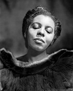
Truro is also the birthplace of world-renowned contralto, Portia White (1911–1968). To support herself while taking music lessons at the Maritime Conservatory of Performing Arts she taught school in Africville and Lucasville. Her national debut occurred in 1941 at the Eaton Auditorium in Toronto, and her international debut came at the Town Hall in New York in 1944. She gave a Command Performance for Queen Elizabeth II at the opening of Confederation Centre in Charlottetown in 1964. A monument commemorating Portia White stands on the grounds of the Zion United Baptist Church.
A number of other prominent Black Canadians have roots in the town. One of Canada's most well known civil rights leader, Burnley Allan "Rocky" Jones, was raised in "the Marsh" neighbourhood of Truro.[9] Art Dorrington, the first black hockey player to sign an NHL contract was raised in "the Island".[10]
Infrastructure and attractions[]

Truro is known as the Hub of Nova Scotia as it is located at the junction between the Canadian National Railway, running between Halifax and Montreal, and the Cape Breton and Central Nova Scotia Railway, running between Truro and Port Hawkesbury. Until the 1980s, Truro also hosted a junction between the Canadian National and Canadian Pacific Railway's former Dominion Atlantic Railway line running through Windsor and down the Annapolis Valley to Yarmouth, Nova Scotia.

An important highway interchange is located just north of Truro in the rural community of Onslow where Highway 102 ends at Highway 104 - both four lane expressways. Secondary roads Trunk 2 and Trunk 4 intersect in the town. Important tertiary roads Route 236 and Route 311 end in the nearby communities of Lower Truro and Onslow respectively. Some of these roads also form part of the Glooscap Trail which is a scenic drive for tourists. Truro railway station is served by Via Rail's Ocean line.
Nova Scotia Power has several transmission line corridors in or near Truro; additionally Bell Aliant, EastLink and 360networks route most of the major telephone and data communications lines in the province through the town.
Six large sections of the Berlin Wall are located along the Cobequid Trail, on the Agricultural Campus of Dalhousie University.[11]
Education[]
Truro has two public high schools, Cobequid Educational Centre and the francophone École acadienne de Truro. Post-secondary options include a campus of the Nova Scotia Community College, and The Institute of Human Services Education, Jane Norman College as well as the Agricultural Campus of Dalhousie University, in the neighboring village of Bible Hill.
Sports[]
Truro has three ice hockey rinks: Deuvilles Rink, Rath Eastlink Community Centre, and the Colchester Legion Stadium. Truro is home to the Truro Bearcats, a Junior "A" ice hockey team who are four time MJAHL Champions. (Canadian) Football is also a popular sport in the town with all games being played on Friday night at the Truro Amateur Athletic Club (TAAC) grounds. Truro Raceway conducts harness races every Sunday. Truro is also home to a rugby club, which hosts the World Indoor Sevens Rugby Championships.
Truro also has a senior baseball team, the Truro Senior Bearcats, that play in the Nova Scotia Senior Baseball League.[12] Their home field is at the Truro Amateur Athletic Club (TAAC).
Lacrosse has become a very popular sport in Truro over the recent years. There is a minor lacrosse association, the Truro Bearcats Lacrosse Association, which allows youth to take part in organized lacrosse teams and games.[13] As well, there is a junior A lacrosse team, the Mi'Kmaq Warriors, that plays in the East Coast Junior Lacrosse League.[14] They play in the summer months out of the Colchester Legion Stadium.
Truro enjoys a vibrant soccer scene centered about the local "CC Riders" soccer club which serves "Tier 2" soccer for both genders and all ages. Outdoor soccer takes place between May and October and indoor 7-a-side and pickup games run through the winter months.
Finally, there is also curling, bowling, swimming, softball, baseball, tennis, golfing, martial arts, snowboarding, snowshoeing, basketball, volleyball, skiing and most everything else either at school and/or local club level.
Notable people[]
- Sir Adams George Archibald, Father of Confederation
- Nora Bernard, Mi'kmaq activist
- Cory Bowles, actor/dancer/musician
- Jenny Brine, retired CWHL ice hockey player
- Matt Brouwer, gospel singer guitarist
- Lyle Carter, retired National Hockey League goaltender (originally from Brookfield)
- Bob Champoux, retired National Hockey League goaltender
- Jocelyne Couture-Nowak, French language instructor who established the École acadienne de Truro, but was shot and killed in the 2007 Virginia Tech massacre
- Glenn V. Davidson, Retired Naval Officer. Recipient of an Honorary Doctorate of Civil Laws from University Kings College.
- Martin Henry Dawson, led pioneering research into DNA and penicillin, found the cure for Subacute Bacterial Endocarditis
- Fred Dickson, Harper appointed member of the Senate of Canada (originally from Glace Bay)
- Art Dorrington, first Black hockey player to sign an NHL contract
- Jeff Douglas, actor (Joe of I Am Canadian) and broadcast presenter
- John Gray, playwright
- Harry Hampton, Scottish-American golf professional
- A. J. B. Johnston, historian and novelist
- Burnley "Rocky" Jones, political activist
- Jeremiah "Jerry" Jones, soldier
- Chet Koneczny, professional lacrosse player
- Brett Lauther, CFL player
- Mary Florence MacDonald, curator
- Lewis MacKenzie, retired Major-General
- Sandy MacKenzie, professional (ice) hockey player
- Greg Maddison, deputy Chief of the Defence Staff
- Jon McIsaac, professional (ice) hockey referee
- Leo McKay Jr., Novelist
- Justin Palardy, professional Canadian football player
- Doug Rogers, Olympian and flag bearer for Canada at the 1972 Olympics.
- Melissa Ann Shepard, Criminal
- Zach Sill, professional (ice) hockey player
- George Isaac Smith, 18th Premier of Nova Scotia (1967-1970); Trudeau appointed member of the Senate of Canada (originally from Stewiacke, Nova Scotia)
- Barry Stagg, singer-songwriter/playwright/musician
- Robert Stanfield, politician
- Bill White, composer/politician/social activist
- Jack White, labour union activist / politician
- Johan Edlund, vocalist and guitarist of Tiamat (band)
- Portia White, singer
- William A. White, church minister and father to Bill, Jack and Portia
- Lenore Zann, actress and politician
Climate[]

Truro has a humid continental climate (Köppen climate classification Dfb) similar to the vast majority of The Maritimes with warm, wet summers and cold, snowy winters.
The highest temperature ever recorded in Truro was 35.6 °C (96 °F) on 19 August 1935 and 15 August 1944.[15][16] The coldest temperature ever recorded was −38.3 °C (−37 °F) on 22 January 1934.[17]
Demographics[]
| Year | Pop. | ±% |
|---|---|---|
| 1762 | 120 | — |
| 1871 | 2,114 | +1661.7% |
| 1881 | 3,461 | +63.7% |
| 1891 | 5,012 | +44.8% |
| 1901 | 5,993 | +19.6% |
| 1911 | 6,017 | +0.4% |
| 1921 | 7,592 | +26.2% |
| 1931 | 7,901 | +4.1% |
| 1941 | 10,272 | +30.0% |
| 1951 | 10,756 | +4.7% |
| 1956 | 12,250 | +13.9% |
| 1961 | 12,421 | +1.4% |
| 1981 | 12,552 | +1.1% |
| 1986 | 12,124 | −3.4% |
| 1991 | 11,683 | −3.6% |
| 1996 | 11,938 | +2.2% |
| 2001 | 11,457 | −4.0% |
| 2006 | 11,765 | +2.7% |
| 2011 | 12,059 | +2.5% |
| 2016 | 12,261 | +1.7% |
| [22][23][24][25][26][27][28][29] | ||
In the 2016 Census of Population conducted by Statistics Canada, the Town of Truro recorded a population of 12,261 living in 6,052 of its 6,574 total private dwellings, a change of 1.7% from its 2011 population of 12,059. With a land area of 34.49 km2 (13.32 sq mi), it had a population density of 355.5/km2 (920.7/sq mi) in 2016.[1]
| Canada 2016 Census | Population | % of Total Population | |
|---|---|---|---|
| Visible minority group Source:[30] |
Black | 490 | 4.2% |
| South Asian | 115 | 1% | |
| Filipino | 85 | 0.7% | |
| Chinese | 75 | 0.6% | |
| Other and mixed visible minority | 95 | 0.8% | |
| Total visible minority population | 860 | 7.3% | |
| Aboriginal group Source:[31] |
First Nations | 355 | 3% |
| Other Aboriginal or self identified | 240 | 2% | |
| Total Aboriginal population | 595 | 5.1% | |
| European Canadian | 10,280 | 87.6% | |
| Total population | 11,735 | 100% | |
See also[]
- List of municipalities in Nova Scotia
- Central Nova Tourist Association — Tourism association representing Cumberland County and Colchester County, including Truro.
References[]
- Davis, Stephen A. (1997). Mi'kmaq. Halifax, Nova Scotia: Nimbus Publishing Limited. ISBN 1551091801.
- ^ Jump up to: a b c "Population and dwelling counts, for Canada, provinces and territories, and census subdivisions (municipalities), 2016 and 2011 censuses – 100% data (Nova Scotia)". Statistics Canada. February 8, 2017. Retrieved February 12, 2017.
- ^ Davis 1997, p. 71.
- ^ "Mi'kmaw Bands in Nova Scotia". Cape Breton University. Retrieved August 21, 2017.
- ^ C. Bruce Fergusson, "Truro", Place-Names and Places of Nova Scotia Nova Scotia Archives (1967), p. 684
- ^ "Tree Sculpture Committee", Town of TruroArchived 2013-01-01 at archive.today
- ^ "Remaining wood sculptures in Truro coming down". Archived from the original on 2020-06-10. Retrieved 2020-06-10.
- ^ Colchester Historical Museum. Canadian Register of Historic Places. Retrieved November 17, 2010.
- ^ "Marking African Heritage Month at Truro's Zion Baptist Church | The Chronicle Herald". www.thechronicleherald.ca. Retrieved 21 May 2019.
- ^ "Treason of the Black Intellectuals? For Burnley A. ('Rocky') Jones (1937-)". Odysseys Home. University of Toronto Press. 31 January 2002.
- ^ "Art Dorrington: A hockey pioneer | Truro News". www.trurodaily.com. Retrieved 21 May 2019.
- ^ "SaltWire".
- ^ "Rosters".
- ^ "Truro Bearcats Lacrosse Association powered by GOALLINE.ca".
- ^ "Mi'Kmaq Warriors Jr a Lacrosse powered by GOALLINE.ca".
- ^ "August 1935". Canadian Climate Data. Environment Canada. 2011-10-31. Retrieved 20 March 2016.
- ^ "August 1944". Canadian Climate Data. Environment Canada. 2011-10-31. Retrieved 20 March 2016.
- ^ "January 1934". Canadian Climate Data. Environment Canada. 2011-10-31. Retrieved 20 March 2016.
- ^ "Truro, Nova Scotia". Canadian Climate Normals 1981–2010. Environment Canada. 2011-10-31. Retrieved 12 April 2015.
- ^ "Truro". Canadian Climate Data. Environment Canada. 2011-10-31. Retrieved 27 June 2016.
- ^ "Truro NSAC". Canadian Climate Data. Environment Canada. 2011-10-31. Retrieved 27 June 2016.
- ^ "Daily Data Report for September 2010". Canadian Climate Data. Environment Canada. 2011-10-31. Retrieved 27 June 2016.
- ^ [1], Censuses 1871-1941
- ^ [2], Census 1941-1951
- ^ 1762 Census Archived 2013-03-07 at archive.today
- ^ [3], Censuses 1871-1931
- ^ Census 1956-1961
- ^ [4], Census 1961
- ^ "Archived copy" (PDF). Archived from the original (PDF) on 2013-10-05. Retrieved 2018-04-20.CS1 maint: archived copy as title (link), Censuses 1981-2001
- ^ [5], Census 2006
- ^ "Community Profiles from the 2016 Census, Statistics Canada - Census Subdivision". 2.statcan.gc.ca. December 6, 2010. Retrieved April 13, 2013.
- ^ "Aboriginal Peoples - Data table". 2.statcan.ca. October 6, 2010. Retrieved April 13, 2013.
- ^ Climate data was recorded at Truro from January 1873 to August 1915, at Truro NSAC from January 1910 to April 2005 and at Debert from December 2003 to present.
External links[]
![]() Media related to Truro, Nova Scotia at Wikimedia Commons
Media related to Truro, Nova Scotia at Wikimedia Commons
- Town of Truro (official website)
| show Authority control |
|---|
- Truro, Nova Scotia