Municipality of the County of Inverness
This article needs additional citations for verification. (July 2021) |
Municipality of the County of Inverness | |
|---|---|
County municipality | |
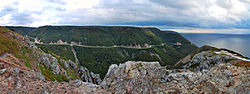 Cabot Trail seen from the Skyline Trail | |
 Location of Inverness County, Nova Scotia | |
| Coordinates: 46°12′N 61°06′W / 46.2°N 61.1°WCoordinates: 46°12′N 61°06′W / 46.2°N 61.1°W | |
| Country | Canada |
| Province | Nova Scotia |
| Towns | Port Hood |
| Established as Juste au Corps | 1835 |
| Renamed Inverness | 1837 |
| Incorporated | 1879 |
| Electoral Districts Federal | Cape Breton—Canso / Sydney—Victoria |
| Provincial | Inverness |
| Government | |
| • Type | Inverness County Municipal Council |
| Area | |
| • Land | 3,831.17 km2 (1,479.22 sq mi) |
| Population | |
| • Total | 17,235 |
| • Density | 4.5/km2 (12/sq mi) |
| • Change 2001-06 | |
| Time zone | UTC-4 (AST) |
| • Summer (DST) | UTC-3 (ADT) |
| Area code(s) | 902 |
| Dwellings | 9,876 |
| Median Income* | $45,687 CDN |
| Website | invernesscounty |

The Municipality of the County of Inverness is a county municipality on Cape Breton Island, Nova Scotia, Canada. It provides local government to about 17,000 residents of the historical county of the same name, except for the incorporated town of Port Hawkesbury and the Whycocomagh 2 Miꞌkmaq reserve, both of which are enclaves. Public services are provided in the areas of recreation, tourism, administration, finance, and public works.[3]
History[]
The county was named after Inverness in the Scottish Highlands from where many immigrants came. The boundaries were defined when Cape Breton Island was divided into districts in 1823. In 1996, the county was amalgamated into a single municipality with the exception of Port Hawkesbury.
Built around 1900 to transport coal to port, the Inverness and Richmond Railway ran from Port Hastings to Inverness. It was abandoned in the 1980s and is now a snowmobile and all-terrain vehicle trail marketed as The Celtic Shores Coastal Trail.[4]
Geography[]
The municipality covers the entire western coast of Cape Breton Island. The rugged western coast borders the eastern extremity of the Gulf of Saint Lawrence, while the eastern side borders Bras d'Or Lake. The land rises to the north, culminating at the Cape Breton Highlands.[5]
As well as Port Hood, site of the municipal offices, populated areas include the fishing ports of Mabou and Judique, and former mining centre Inverness. The municipality contains an Acadian enclave at the ports of Saint-Joseph-du-Moine and Chéticamp.
Demographics[]
In the Canada 2016 Census, the municipality had a population of 13,190 and 8,842 dwellings, a population drop of 4.3% from 2011.[6] The municipality accounts for 1.5% of the population of Nova Scotia.
Economy[]
Agriculture, forestry, fishing, and hunting account for 32% of the economy.[7] Other major sectors are construction, retail, accommodation, and food services.
More than 80% by value of Nova Scotia's fishery is in Inverness. The main species are shellfish such as lobster, crab, scallop, and shrimp.[7]
Ranching and animal production is the main agricultural activity.[7]
In terms of employment by sector, it is: Agriculture, forestry, fishing and hunting 12%; retail 12%; health care 12%; manufacturing 10%; accommodation and food services 9%.[8]
Fifty-seven per cent of the municipalities expenses go towards public housing, more than double the provincial rural average.[6]
In 2020 the municipality received about $1.9 million in infrastructure funding from the government and local groups.[9]
Infrastructure[]
The municipality is served by highways Trans-Canada Highway passes through.
There is access to the Strait of Canso, which has the deepest year-round harbour on the east coast of North America.[10]
Policing is provided by the federal Royal Canadian Mounted Police.
Education[]
The Université Sainte-Anne in Pointe-de-l'Église,[11] along with the Université de Moncton in New Brunswick are the only French language universities in Atlantic Canada.
See also[]
- List of historic places in Inverness County
- Landforms of Inverness County
References[]
- ^ a b 2006 Statistics Canada Community Profile: Inverness County, Nova Scotia
- ^ Statistics Canada Population and dwelling counts, for Canada and census subdivisions (municipalities), 2006 and 2001 censuses - 100% data
- ^ "Government". Inverness. Retrieved 27 July 2021.
- ^ "Celtic Shores Coastal Trail, Inverness County Trails". www.celticshores.ca. Retrieved 28 July 2021.
- ^ Muise, D.A. "Cape Breton Island". www.thecanadianencyclopedia.ca. The Canadian Encyclopedia. Retrieved 28 July 2021.
- ^ a b "Municipal Reports". invernesscounty.ca. Municipality of the County of Inverness. 2018. Retrieved 27 July 2021.
- ^ a b c "Key Industries". invernesscounty.ca. Municipality of the County of Inverness. Retrieved 27 July 2021.
- ^ "Labour Force". invernesscounty.ca. Municipality of the County of Inverness. Retrieved 27 July 2021.
- ^ "Federal government supports enhanced tourism infrastructure in Inverness County". Municipal World. Retrieved 27 July 2021.
- ^ "Strategic Location". invernesscounty.ca. Municipality of the County of Inverness. Retrieved 27 July 2021.
- ^ "Université Sainte-Anne". Archived from the original on 26 August 2014. Retrieved 22 August 2014.
Subdivisions of Nova Scotia | |
|---|---|
| Counties | |
| County municipalities | |
| Regional municipalities | |
| District municipalities | |
| Towns | |
| Villages | |
| Economic regions | |
| Lists | |
| |
- Inverness County, Nova Scotia
- County municipalities in Nova Scotia