Claut
Claut | |
|---|---|
| Comune di Claut | |
show Location of Claut | |
 Claut Location of Claut in Italy | |
| Coordinates: 46°16′N 12°31′E / 46.267°N 12.517°E | |
| Country | Italy |
| Region | Friuli-Venezia Giulia |
| Province | Pordenone (PN) |
| Frazioni | Cellino di sopra, Cellino di sotto, Contròn, Creppi, Lesis, Matàn, Pinedo, Stoc, Vit |
| Government | |
| • Mayor | Gionata Sturam |
| Area | |
| • Total | 166.3 km2 (64.2 sq mi) |
| Elevation | 613 m (2,011 ft) |
| Population (31 December 2010)[3] | |
| • Total | 1,027 |
| • Density | 6.2/km2 (16/sq mi) |
| Demonym(s) | Clautani or Clautàns |
| Time zone | UTC+1 (CET) |
| • Summer (DST) | UTC+2 (CEST) |
| Postal code | 33080 |
| Dialing code | 0427 |
| Website | Official website |


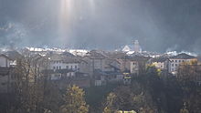
the town
Claut (Western Friulian: Cjolt) is a comune (municipality) in the Province of Pordenone in the Italian region Friuli-Venezia Giulia, located about 120 kilometres (75 mi) northwest of Trieste and about 35 kilometres (22 mi) northwest of Pordenone.
Claut borders the following municipalities: Barcis, Chies d'Alpago, Cimolais, Erto e Casso, Forni di Sopra, Forni di Sotto, Frisanco, Pieve d'Alpago, Tramonti di Sopra.
People[]
References[]
- ^ "Superficie di Comuni Province e Regioni italiane al 9 ottobre 2011". Istat. Retrieved 16 March 2019.
- ^ "Popolazione Residente al 1° Gennaio 2018". Istat. Retrieved 16 March 2019.
- ^ All demographics and other statistics: Italian statistical institute Istat.
External links[]
| show Authority control |
|---|
Categories:
- Cities and towns in Friuli-Venezia Giulia
- Municipalities of the Province of Pordenone
- Friuli-Venezia Giulia geography stubs