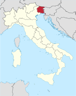
Friuli Venezia Giulia
Friuli Venezia Giulia
Friûl Vignesie Julie (Friulian) Furlanija Julijska krajina (Slovene) Friaul Julisch Venetien (German)[1] | |
|---|---|
Autonomous region of Italy | |
 Flag  Coat of arms | |
 | |
| Country | Italy |
| Capital | Trieste |
| Government | |
| • President | Massimiliano Fedriga (LN) |
| Area | |
| • Total | 7,924 km2 (3,059 sq mi) |
| Population (31 August 2017) | |
| • Total | 1,216,524 |
| • Density | 150/km2 (400/sq mi) |
| Demonym(s) | English: Friuli Venezia Giulian Italian: Friulano (man) Italian: Friulana (woman) or Italian: Giuliano (man) Italian: Giuliana (woman) |
| Time zone | UTC+1 (CET) |
| • Summer (DST) | UTC+2 (CEST) |
| ISO 3166 code | IT-36 |
| GDP (nominal) | €38 billion (2018)[2] |
| GDP per capita | €31,200 (2018)[3] |
| HDI (2019) | 0.903[4] very high · 7th of 21 |
| NUTS Region | ITD |
| Website | www.regione.fvg.it |
Friuli Venezia Giulia (pronounced [friˈuːli veˈnɛttsja ˈdʒuːlja])[a] is one of the 20 regions of Italy, and one of five autonomous regions with special statute. The regional capital is Trieste.
The name used to be hyphenated as Friuli-Venezia Giulia until 2001. The region is called Friûl Vignesie Julie in Friulian, Furlanija Julijska krajina in Slovene and Friaul Julisch Venetien in German, three languages spoken in the region. The city of Venice ("Venezia") is not in this region, despite the name.
Friuli Venezia Giulia has an area of 7,924 km2 and about 1.2 million inhabitants. A natural opening to the sea for many Central European countries, the region is traversed by the major transport routes between the east and west of southern Europe. It encompasses the historical-geographical region of Friuli and a small portion of the historical region of Venezia Giulia – also known in English as the Julian March – each with its own distinct history, traditions and identity.
History[]
This section needs additional citations for verification. (July 2021) |

In Roman times, modern Friuli Venezia Giulia was located within Regio X Venetia et Histria of Roman Italy. The traces of its Roman origin are visible all over the area. In fact, the city of Aquileia, founded in 181 BC, served as regional capital and rose to prominence in the Augustan era.
Following the Lombard settlements in the 6th century, the historical paths of Friuli and Venezia Giulia began to diverge. In 568, Cividale del Friuli (the Roman Forum Iulii (from which the name Friuli is derived)) became the capital of the first Lombard dukedom in Italy. In 774, the Franks, favored the growth of the church of Aquileia and established Cividale as a march. In 1077, the Holy Roman Emperor recognized the territorial powers of the Patriarchate of Aquileia that temporarily extended its rule to areas to the east. Already in the 12th century Gorizia had become independent and Triest, along with other coastal towns, developed into a free city-state.
In the 6th century, the Alpine Slavs, ancestors of present-day Slovenes, settled the eastern areas of the region. They settled in the easternmost mountainous areas of Friuli known as the Friulian Slavia, as well as in the Kras Plateau and in the area north and south of Gorizia. In the 12th and 13th centuries they also moved closer to Triest.

Friuli became Venetian territory in 1420, while Triest and Gorizia remained within the Holy Roman Empire. Pordenone was a "corpus separatum", under Austrian influence until 1515, when it also fell to Venetian rule. With the 1797 Peace treaty of Campoformido, the Venetian domination came to an end and Friuli was ceded to Austria. After the period of domination by Napoleon, which affected also Triest and Gorizia, it again became part of the Austrian Empire and was included in the Lombard-Veneto Kingdom. Gorizia was assigned to the Illyrian Kingdom, whereas Triest and Istria became part of the Austrian Coastal Region. Under the enlightened government and policies set by the Austrian Empire and continued by the Austrian-Hungarian Empire in the 18th and 19th centuries, Triest flourished, reaching an extraordinary economic development as the main harbour of the Habsburg empire. The war of independence led to the annexation of Friuli to the Kingdom of Italy.
During the First World War the region was a prominent theatre for military operations and suffered serious damage and loss of lives. After the war these borderlands were united within the Kingdom of Italy, although Venezia Giulia's borders were the subject of an international dispute.
The Second World War led to the creation of the Anglo-American Administration in Trieste until the border was defined in the 1954 Memorandum of London.[citation needed] After Triest was reassigned to Italy, the Autonomous Region of Friuli Venezia Giulia was finally established.[citation needed][9]
The region's name was Friuli-Venezia Giulia (hyphenated) until 2001, when the official spelling Friuli Venezia Giulia (without hyphen) was adopted following the modification of Article No.116 of the Italian Constitution[10][11][12] The term "Venezia Giulia" was coined by Graziadio Isaia Ascoli.
Geography[]
This section does not cite any sources. (October 2018) |
Friuli Venezia Giulia is Italy's north-easternmost region. It covers an area of 7,858 km2 and is the fifth smallest region of the country. It borders Austria to the north and Slovenia to the east. To the south it faces the Adriatic Sea and to the west the Veneto region.
The region spans a wide variety of climates and landscapes from the mild Oceanic in the south to Alpine continental in the north. The total area is subdivided into a 42.5% mountainous-alpine terrain in the north, 19.3% is hilly, mostly to the south-east, while the remaining 38.2% comprises the central and coastal plains.

Morphologically the region can be subdivided into four main areas. The mountainous area in the north: this part of the region includes Carnia and the ending section of the Alps (Carnic Alps and Julian Alps), of which the highest peaks exceed 2,700 m above sea level (Jôf di Montasio 2,754 m). Its landscapes are characterised by vast pine forests and pastures, mountain lakes (e.g. Sauris, Fusine and Barcis) and numerous streams and small rivers descending from the mountains.
The area is also known for its tourist destinations, especially during the winter season (Monte Zoncolan, Tarvisio, Sella Nevea, Forni di Sopra and Piancavallo). The hilly area is situated to the south of the mountains and along the central section of the border with Slovenia. The main product of agriculture in this area is wine, whose quality, especially the white, is known worldwide. The easternmost part of the hilly area is also known as Slavia Friulana, as it is mostly inhabited by ethnic Slovenes.
The central plains are characterised by poor, arid and permeable soil. The soil has been made fertile with an extensive irrigation system and through the adoption of modern intensive farming techniques. In this part of the region most of the agricultural activities are concentrated. The coastal area can be further subdivided in two, western-eastern, subsections separated by the river Isonzo's estuary.
To the west, the coast is shallow and sandy, with numerous tourist resorts and the lagoons of Grado and Marano Lagunare. To the east, the coastline rises into cliffs, where the Karst plateau meets the Adriatic, all the way to Trieste and Muggia on the border with Slovenia. The Carso has geological features and phenomena such as hollows, cave networks and underground rivers, which extend inland in the provinces of Trieste and Gorizia, with an altitude ranging between 300m and 600m.

The rivers of the region flow from the North and from Slovenia into the Adriatic. The two main rivers are the Tagliamento, which flows west–east in its upper part in the Carnic Alps and then bends into a north–south flow that separates the Julian Alps from Alpine foothills and the Isonzo (Soča slo.) which flows from Slovenia into Italy. The Timavo is an underground river that flows for 38 km from Slovenia and resurfaces near its mouth north-west of Duino.
The region Friuli Venezia Giulia has a temperate climate. However, due to the terrain's diversity, it varies considerably from one area to another. Walled by the Alps on its northern flank, the region is exposed to air masses from the East and the West. The region receives also the southerly Sirocco from the Adriatic sea, which brings in heavy rainfall. Along the coast the climate is mild and pleasant.
Trieste records the smallest temperature differences between winter and summer and between day and night. The climate is in the mountainous areas, where, in some locations, the coldest winter temperatures in Italy can often be found. The Kras plateau has its own weather and climate, influenced, mostly during autumn and winter, by masses of cold air coming from the north-east. These generate a very special feature of the local climate: the north-easterly wind Bora, which descends onto the Gulf of Trieste with gusts occasionally exceeding speeds of 150 km/h.
Economy[]
This section contains content that is written like an advertisement. (January 2020) |
The Gross domestic product (GDP) of the region was 38 billion euros in 2018, accounting for 2.2% of Italy's economic output. GDP per capita adjusted for purchasing power was 31,200 euros or 103% of the EU27 average in the same year. The GDP per employee was 106% of the EU average.[13]

The economy of Friuli Venezia Giulia is one of the most developed in the country. Its core is based on small- and middle-size enterprises (the so-called 'North-East model'), on specialized farming and on high-quality tourism with a significant inclination towards exports.[14]
Agriculture and farming maintain an essential role in the economy of the region and employed in 2001 around 95,000 persons. Its high quality products are exported not only within the country and Europe (fruit and vegetable, cheese) but have become known worldwide for their quality (cured ham and wines, especially white ones). Noteworthy is also the production of soy (third producer in Italy with more than 37,000 hectares cultivated in 2000) and timber production in Carnia.[14]
As mentioned above, the economy of the region is based on a widespread mosaic of small and medium-size enterprises; of particular importance are the four industrial districts where a multitude of such highly specialised enterprises are concentrated. These districts are centred around the towns of Manzano, San Daniele del Friuli (cured ham), Maniago (knives) and Brugnera (furniture). A number of large enterprises are also present in the region in both the industry and services sector. Some of these companies are world-leaders in their relevant sectors; such are Fincantieri (headquarters in Trieste with shipyards in Monfalcone) for the construction of the world's largest cruise ships, Zanussi-Electrolux (Pordenone) in the production of electrical appliances, Danieli, Eurotech, Illy, Rizzani de Eccher, Solari di Udine, TBS Group, Banca Generali, Genertellife, Italia Marittima, Telit, Wärtsilä, Allianz Italia and Assicurazioni Generali in Trieste, a leading insurance company in the world.[14]

Again, in the services sector the city of Trieste plays a leading role (with knock-on effects on the other provincial capitals); it is in fact here that activities such as the regional government, large banking and insurance companies are concentrated.
The unemployment rate stood at 5.7% in 2020.[15]
Transport[]
With its commercial Free Port, Trieste also plays an essential role in the trade sector: special custom regulations ensure exclusive financial conditions to operators. The Port of Trieste is today the most important centre worldwide for the trade of coffee and plays a strategic key role in trade with northern and eastern Europe-[14]

Although small in size, Friuli Venezia Giulia has always been 'in the centre of Europe' and has played an important role in connecting Italy (and the Mediterranean) to Central and Eastern Europe. Its role will become even more strategic as a logistical platform with the imminent enlargement of the European Union. Hence the importance of the infrastructure network of the region, which can today be considered first rate in quality and diversity. The motorway network consists of more than 200 km that run from North to South and from West to East, perfectly connecting the region to Austria and Slovenia.[14]
The railway network consists of around 500 km of track, with the two twin-line 'backbones' Venice-Trieste and Trieste-Udine-Tarvisio-Austria. The motorway and railway networks are linked to the ports of Trieste, Monfalcone and Porto Nogaro, the three most northerly ports of the Mediterranean. Trieste, in particular, has a free port for goods since 1719. It is the Italian port with the greatest capacity for covered storage, with a surface area of more than 2 million square meters and 70 km of rail tracks. Intermodality is guaranteed by the Cervignano terminal, in operation since 1988, to serve the increasing commercial traffic between Italy and Eastern European countries.[14]
The regional airport of Ronchi dei Legionari is situated 30 km from Trieste and 40 km from Udine and is closely connected to the motorway and railway networks. The airport offers regular national and international flights including destinations in Eastern Europe. The region is now placing much of its hopes for future economic development in the construction of a high speed European Transport Corridor n° V connecting Lyon, Turin, Venice, Trieste, Ljubljana, Budapest and Kiev, so as to improve the traffic of goods and services with new EU partners.[14]
Demographics[]
| Year | Pop. | ±% |
|---|---|---|
| 1871 | 508,000 | — |
| 1881 | 530,000 | +4.3% |
| 1901 | 615,000 | +16.0% |
| 1911 | 728,000 | +18.4% |
| 1921 | 1,178,000 | +61.8% |
| 1931 | 1,176,000 | −0.2% |
| 1936 | 1,108,000 | −5.8% |
| 1951 | 1,226,000 | +10.6% |
| 1961 | 1,204,000 | −1.8% |
| 1971 | 1,214,000 | +0.8% |
| 1981 | 1,234,000 | +1.6% |
| 1991 | 1,198,000 | −2.9% |
| 2001 | 1,184,000 | −1.2% |
| 2011 | 1,235,000 | +4.3% |
| 2017 | 1,217,872 | −1.4% |
| Source: ISTAT 2001 | ||
Population density is lower than the national average: In 1978 there were in total only 1,224,611 inhabitants;[16] in 2008 it was 157.5 inhabitants per km2 (compared to 198.8 for Italy as a whole). However, density varies from a minimum of 106 inhabitants per km2 in the province of Udine to a maximum of 1,144 inhabitants per km2 in the province of Trieste.
The negative natural balance in the region is partly made up by the positive net migration. To some extent the migratory surplus has in fact offset the downward trend in the population since 1975. In 2008, the resident population with foreign nationality registered in the region accounted to 83,306 persons (6.7% of the total population).
Government and politics[]
This section needs additional citations for verification. (July 2021) |

A special Italian statute of 31 January 1963 effective 16 February 1963 constituted Friuli Venezia Giulia as an autonomous region within the Italian Republic.
The President of Regional Government is the region's head of government. Executive power is exercised by the and legislative power is vested in both the government and the Regional Council. In the latest regional election, which took place on 4 March 2018, Massimiliano Fedriga of the Lega Nord Friuli-Venezia Giulia was elected president by a landslide.
Administrative divisions[]
Friuli Venezia Giulia is subdivided into 18 (UTI;[17] "intermunicipal territorial unions"[18]), a type of administrative unit unique to the region, and 215 comuni. Regional statute also allows for the establishment of a metropolitan city of Trieste.
Like most of the rest of Italy, Friuli Venezia Giulia was previously divided into four provinces: Gorizia, Pordenone, Trieste and Udine. The first three were abolished on 30 September 2017,[19] while the Province of Udine remained active until 22 April 2018.[20]
Unione territoriale intercomunale[]
| UTI name | Seat | Former province | Constituent comuni | Number of comuni | Area (km2) | Population | |
|---|---|---|---|---|---|---|---|
| a | Trieste | TS | Duino-Aurisina, Monrupino, Muggia, San Dorligo della Valle, Sgonico, Trieste | 6 | 212.5 | 232,601 | |
| b | Monfalcone | GO | Doberdò del Lago, Grado, Fogliano Redipuglia*, Monfalcone, Ronchi dei Legionari, Sagrado, San Canzian d'Isonzo, San Pier d'Isonzo, Staranzano, Turriaco | 10 | 264.8 | 72,499 | |
| c | Gorizia | GO | Capriva del Friuli, Cormons, Dolegna del Collio*, Farra d'Isonzo, Gorizia, Gradisca d'Isonzo, Mariano del Friuli, Medea, Moraro, Mossa, Romans d'Isonzo, San Floriano del Collio*, San Lorenzo Isontino, Savogna d'Isonzo*, Villesse | 15 | 202.3 | 67,644 | |
| d | Tarvisio | UD | Chiusaforte*, Dogna, Malborghetto-Valbruna, Moggio Udinese*, Pontebba, Resia*, Resiutta, Tarvisio* | 8 | 885.0 | 11,164 | |
| e | Gemona del Friuli | UD | Artegna, Bordano, Gemona del Friuli*, Montenars, Trasaghis, Venzone | 6 | 235.3 | 19,893 | |
| f | Tolmezzo | UD | Amaro, Ampezzo*, Arta Terme, Cavazzo Carnico, Cercivento*, Comeglians, Enemonzo, Forni Avoltri, Forni di Sopra, Forni di Sotto*, Lauco, Ovaro, Paluzza, Paularo, Prato Carnico, Preone, Ravascletto, Raveo, Rigolato, Sappada*, Sauris, Socchieve, Sutrio, Tolmezzo, Treppo Ligosullo, Verzegnis, Villa Santina, Zuglio* | 28 | 1,286 | 39,882 | |
| g | Udine | UD | Campoformido, Martignacco*, Pagnacco*, Pasian di Prato*, Pavia di Udine*, Pozzuolo del Friuli, Pradamano, Reana del Rojale*, Tavagnacco, Tricesimo, Udine | 11 | 274.1 | 170,123 | |
| h | Tarcento | UD | Attimis, Cassacco, Faedis, Lusevera, Magnano in Riviera*, Nimis, Povoletto, Taipana, Tarcento | 9 | 326.4 | 36,651 | |
| i | Codroipo | UD | Basiliano, Bertiolo, Camino al Tagliamento*, Castions di Strada*, Codroipo*, Lestizza*, Mereto di Tomba, Mortegliano*, Sedegliano, Talmassons*, Varmo | 11 | 419.6 | 51,812 | |
| j | San Daniele del Friuli | UD | Buja*, Colloredo di Monte Albano*, Coseano, Dignano*, Fagagna, Flaibano, Forgaria nel Friuli*, Majano, Moruzzo, Osoppo*, Ragogna*, Rive d'Arcano, San Daniele del Friuli*, San Vito di Fagagna*, Treppo Grande | 15 | 349.8 | 51,241 | |
| k | Cividale del Friuli | UD | Buttrio, Cividale del Friuli, Corno di Rosazzo*, Drenchia, Grimacco, Manzano, Moimacco, Premariacco, Prepotto, Pulfero, Remanzacco, San Giovanni al Natisone, San Leonardo, San Pietro al Natisone, Savogna, Stregna, Torreano* | 17 | 456.5 | 52,112 | |
| l | Latisana | UD | Carlino, Latisana, Lignano Sabbiadoro, Marano Lagunare, Muzzana del Turgnano, Palazzolo dello Stella, Pocenia, Porpetto, Precenicco, Rivignano Teor*, Ronchis*, San Giorgio di Nogaro | 12 | 438.4 | 56,332 | |
| m | Cervignano del Friuli | UD | Aiello del Friuli, Aquileia, Bagnaria Arsa, Bicinicco, Campolongo Tapogliano, Cervignano del Friuli, Chiopris-Viscone, Fiumicello Villa Vicentina, Gonars*, Palmanova, Ruda, San Vito al Torre*, Santa Maria la Longa*, Torviscosa, , Trivignano Udinese*, Visco* | 17 | 298.7 | 55,148 | |
| n | San Vito al Tagliamento | PN | Casarsa della Delizia, Cordovado, Morsano al Tagliamento, San Giorgio della Richinvelda, San Martino al Tagliamento, San Vito al Tagliamento, Sesto al Reghena, Spilimbergo*, Valvasone Arzene | 9 | 334.3 | 57,278 | |
| o | Maniago | PN | Andreis, Arba, Barcis, Castelnovo del Friuli, Cavasso Nuovo*, Cimolais, Claut, Clauzetto, Erto e Casso, Fanna*, Frisanco, Maniago, Meduno, Montereale Valcellina, Pinzano al Tagliamento, Sequals, Tramonti di Sopra, Tramonti di Sotto, Travesio, Vajont, Vito d'Asio, Vivaro | 22 | 1,148.1 | 37,086 | |
| p | Sacile | PN | Aviano, Brugnera*, Budoia, Caneva, Polcenigo*, Sacile* | 6 | 304.0 | 50,408 | |
| q | Azzano Decimo | PN | Azzano Decimo, Chions, Fiume Veneto, Pasiano di Pordenone*, Prata di Pordenone*, Pravisdomini | 6 | 205.3 | 51,993 | |
| r | Pordenone | PN | Cordenons*, Fontanafredda, Porcia, Pordenone, Roveredo in Piano, San Quirino*, Zoppola | 7 | 283.6 | 114,046 |
(*) These municipalities have not yet[when?] signed the statute of the UTI to which they belong.

Former provinces[]

Until 2017–18, Friuli Venezia Giulia was divided into four provinces:
| Province (listed west to east) |
Area (km2) | Population | Density (inh./km2) |
|---|---|---|---|
| Province of Pordenone | 2,273 | 311,931 | 137.2 |
| Province of Udine | 4,905 | 539,224 | 109.9 |
| Province of Gorizia | 466 | 142,392 | 305.5 |
| Province of Trieste | 212 | 236,445 | 1,115.3 |
Culture[]

Language[]
The official languages of the region are Italian, Friulian, Slovene and German.[1]
Italian is the official national language. Friulian language is also spoken in most of the region — with a few exceptions, most notably Trieste and the area around Monfalcone and Grado, where a version of the Venetian language and Triestine dialect is spoken instead.[citation needed]
Venetian is also spoken in western part of the Province of Pordenone, and in the city of Pordenone itself, due to its proximity with the Veneto region. Friulian and Venetian are more common in the countryside, while standard Italian is the predominant language in the larger towns (Udine, Pordenone, Gorizia). The region is also home to Italy's Slovene-speaking minority.[citation needed]
Historical Flag[]
A very popular symbol among the Friulian community (mostly identified with the friulian-speaking population in the provinces of Udine, Pordenone and Gorizia and the numerous expat communities around the world) is the Friulian Historical Flag, to which the official regional flag is roughly inspired, being somehow a modern interpretation of it. The official, modern "Friuli-Venezia Giulia" flag logo was issued in 1967-1968[22] (and adopted in 2001) to represent the region which in 1963[23] took the administrative setup of today. The historical symbol of the eagle dates back to (at least) the 13th century, the time of the Patriarchate of Aquileia.[citation needed]
Notes[]
References[]
- ^ Jump up to: a b "Regione Autonoma Friuli Venezia Giulia - Comunità linguistiche regionali". www.regione.fvg.it.
- ^ "Regional gross domestic product (million EUR) by NUTS 2 regions". Eurostat. Eurostat. Retrieved 9 July 2012.
- ^ "Regional GDP per capita ranged from 31% to 626% of the EU average in 2017" (Press release). ec.europa.eu. Retrieved 2 September 2019.
- ^ "Sub-national HDI - Area Database - Global Data Lab". hdi.globaldatalab.org. Retrieved 2019-09-13.
- ^ "Friuli-Venezia Giulia". The American Heritage Dictionary of the English Language (5th ed.). Boston: Houghton Mifflin Harcourt. Retrieved 6 May 2019.
- ^ "Friuli-Venezia Giulia".
- ^ "Friuli-Venezia Giulia". Oxford Dictionaries UK Dictionary. Oxford University Press. Retrieved 6 May 2019.
- ^ "Friuli-Venezia Giulia". Merriam-Webster Dictionary. Retrieved 6 May 2019.
- ^ "Sito Ufficale della Regione Autonoma Friuli–Venezia Giulia – Versione Inglese". Regione.fvg.it. Retrieved 2009-05-05.
- ^ "Modifiche al titolo V della parte seconda della Costituzione". parlamento.it. 18 October 2001.
- ^ "Costituzione della Repubblica Italiana" (PDF) (in Italian). Archived from the original (PDF) on 20 June 2006. Retrieved 10 September 2014.
- ^ Sarti, Gianpaolo: La Lega lancia la regione "Friuli e Trieste", in: Il Piccolo, 9 September 2014, p. 14.
- ^ "Regional GDP per capita ranged from 30% to 263% of the EU average in 2018". Eurostat.
- ^ Jump up to: a b c d e f g "Eurostat". Circa.europa.eu. Archived from the original on 2010-04-18. Retrieved 2009-05-05.
- ^ "Unemployment NUTS 2 regions Eurostat".
- ^ Prost, Brigitte: Le Frioul.Région d#affrontements, Géneve 1973.
- ^ "Enti locali: Approvata la proposta del piano di riordino territoriale del FV". 4 February 2015. Retrieved 20 April 2019. (in Italian)
- ^ "Local development challenges and the role of "wide areas" in strategic planning. The case of inter-municipal territorial unions of Friuli Venezia Giulia (Italy)". iris.unibocconi.it. Retrieved 2021-02-18.
- ^ "Soppressione delle Province del Friuli Venezia Giulia". Consiglio regionale del Friuli Venezia Giulia. 14 December 2016. Retrieved 20 April 2019. (in Italian)
- ^ "Nomina del commissario liquidatore". Provincia di Udine. 16 May 2018. Retrieved 20 April 2019. (in Italian)
- ^ "Unioni Territoriali intercomunali (UTI)" (PDF). Archived from the original (PDF) on 24 December 2016. Retrieved 23 April 2017.
- ^ "pending".[dead link]
- ^ "pending".[dead link]
Gallery[]
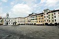
Piazza San Giacomo in Udine

The Miramare Castle in Trieste

The lake of Fusine in Valromana

The Devil's Bridge in Cividale del Friuli

Terrazza Mare in Lignano Sabbiadoro

The

The bay of Sistiana

Piazza Unità d'Italia in Trieste

The sea in Trieste

Sanctuary in Mount Lussari, Tarvisio

The Tagliamento river near Pinzano
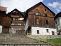
Typical houses in Carnia


External links[]
| Wikimedia Commons has media related to Friuli-Venezia Giulia. |
- "Turismo in Friuli Venezia Giulia 2018" Guide. For translation, click "Translate" button at bottom of screen.
- Official site of the Autonomous Region of Friuli Venezia Giulia (Italian, Friulan, Slovene, German, English)
- Official site of the Autonomous Region of Friuli Venezia Giulia (in German, Slovene, and Friulian)
- fvg.INFO (Italian, English, German)
- Giro FVG - Rivista turistica, web, App iPhone, iPad, iPod del Friuli Venezia Giulia (Italian)
- Friuli Tipico (Italian, English)
- Map of Friuli Venezia Giulia
- "The official Website for tourism of Friuli Venezia Giulia. Welcome". Friuli Venezia Giulia. (Italian, English, German)
- Airport of Friuli Venezia Giulia (Italian, English, Slovene)
- "meteo.fvg: Regione Autonoma Friuli Venezia Giulia". OSMER: Osservatorio Meteorologico Regionale. (Italian, Friulan, Slovene, German, English)

| show |
|---|
Coordinates: 45°38′10″N 13°48′15″E / 45.63611°N 13.80417°E

| show Authority control |
|---|
- Friuli-Venezia Giulia
- Regions of Italy
- NUTS 2 statistical regions of the European Union
- States and territories established in 1989
- Autonomous regions of Italy
- Hungarian diaspora in Italy