Geography of Italy
This article may be expanded with text translated from the corresponding article in Italian. (August 2021) Click [show] for important translation instructions.
|
 | |
| Continent | Europe and Africa (Lampedusa and Lampione islands) |
|---|---|
| Region | South Europe |
| Coordinates | 42°00′N 12°05′E / 42.000°N 12.083°ECoordinates: 42°00′N 12°05′E / 42.000°N 12.083°E |
| Area | |
| • Total | 301,339 km2 (116,348 sq mi) |
| • Land | 97.61% |
| • Water | 2.39% |
| Coastline | 7,600 km (4,700 mi) |
| Borders | Total land borders 1836.4 km |
| Highest point | Mont Blanc 4,810 m |
| Lowest point | Jolanda di Savoia -3.44 m |
| Longest river | Po 652 km |
| Largest lake | Garda 370 km2 (140 sq mi) |
| Exclusive economic zone | 541,915 km2 (209,235 sq mi) |

Italy is located in southern Europe and comprises the long, boot-shaped Italian Peninsula, the southern side of Alps, the large plain of the Po Valley and some islands including Sicily and Sardinia. Corsica, although part of the Italian geographical region, has been administered by France since the 18th century. Italy is part of the Northern Hemisphere. Two of the Pelagie Islands (Lampedusa and Lampione) are located on the African continent.
Its total area is 301,340 km2 (116,350 sq mi), of which 294,140 km2 (113,570 sq mi) is land and 7,200 km2 is water (2,780 sq mi). It lies between latitudes 35° and 47° N, and longitudes 6° and 19° E.
Italy borders Switzerland (698 km or 434 mi), France (476 km or 296 mi), Austria (404 km or 251 mi) and Slovenia (218 km or 135 mi). San Marino (37 km or 23 mi) and Vatican city (3.4 km or 2.1 mi) are enclaves. The total border length is 1,836.4 km (1,141.1 mi).
Including islands, Italy has a coastline of 7,600 km (4,700 mi) on the Adriatic Sea, Ionian Sea, Tyrrhenian Sea, Ligurian Sea, Sea of Sardinia and Strait of Sicily.
Mountains and plains[]

Almost 40% of the Italian territory is mountainous,[1] with the Alps as the northern boundary and the Apennine Mountains forming the backbone of the peninsula and extending for 1,350 km (840 mi).[1] In between the two lies a large plain in the valley of the Po, the largest river in Italy, which flows 652 km (405 mi) eastward from the Cottian Alps to the Adriatic. The Po Valley is the largest plain in Italy, with 46,000 km2 (18,000 sq mi), and it represents over 70% of the total plain area in the country.[1]
The Alpine mountain range is linked with the Apennines with the Colle di Cadibona pass in the Ligurian Alps.
Worldwide-known mountains in Italy are Monte Cervino (Matterhorn), Monte Rosa, Gran Paradiso in the West Alps, and Bernina, Stelvio and Dolomites along the eastern side of the Alps. The highest peak in Italy is Mont Blanc, at 4,810 meters (15,780 ft) above sea level.
Volcanoes[]
Many elements of the Italian territory are of volcanic origin. Most of the small islands and archipelagos in the south, like Capraia, Ponza, Ischia, Eolie, Ustica and Pantelleria are volcanic islands. There are also active volcanoes: Etna, in Sicily, the largest active volcano in Europe; Vulcano, Stromboli, and Vesuvius, near Naples, the only active volcano on mainland Europe.
Rivers and seas[]
Most of Italy's rivers drain either into the Adriatic Sea (like Po, Piave, Adige, Brenta, Tagliamento, Reno) or into the Tyrrhenian (like Arno, Tiber and Volturno), though the waters from some border municipalities drain into the Black Sea through the basin of the Drava (Innichen and Sexten in Trentino-Alto Adige/Südtirol, Tarvisio in Friuli-Venezia-Giulia) or the Inn (Livigno in Lombardy), both tributaries of the Danube, and the waters from the Lago di Lei in Lombardy drain into the North Sea through the basin of the Rhine.
Maritime claims[]
- Territorial sea: 12 nmi (22.2 km; 13.8 mi)
- Continental shelf: 200-metre depth (660 ft) or to the depth of exploitation
- Exclusive Economic Zone: 541,915 km2 (209,235 sq mi)
Lakes[]
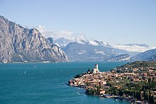
In the north of the country are a number of subalpine moraine-dammed lakes (the Italian Lakes), the largest of which is Garda (370 km2 or 143 sq mi). Other well known of these subalpine lakes are Lake Maggiore (212.5 km2 or 82 sq mi), whose most northerly section is part of Switzerland, Como (146 km2 or 56 sq mi), Orta, Lugano, Iseo, Idro.
Other notable lakes in the Italian peninsula are Trasimeno, Bolsena, Bracciano, Vico, Varano and Lesina in Gargano and Omodeo in Sardinia.
Islands[]
Italy includes several islands. The largest are Sicily 25,708 km2 (9,926 sq mi) and Sardinia 24,090 km2 (9,300 sq mi). The third largest island is Elba, the largest island of the Tuscan Archipelago (224 km2 or 86 sq mi).
Latitude and longitude[]
- Northernmost point — Testa Gemella Occidentale, Prettau (Predoi), South Tyrol at 47°5′N 12°11′E / 47.083°N 12.183°E
- Southernmost point — Punta Pesce Spada, Lampedusa, Sicily at 35°29′N 12°36′E / 35.483°N 12.600°E (whole territory); , Palizzi, Calabria at 37°55′N 15°59′E / 37.917°N 15.983°E (mainland)
- Westernmost point — Rocca Bernauda, Bardonecchia, Piedmont at 45°6′N 6°37′E / 45.100°N 6.617°E
- Easternmost point — Capo d'Otranto, Otranto, Apulia at 40°6′N 18°31′E / 40.100°N 18.517°E
Elevation[]
- Highest: Mont Blanc, Courmayeur (4807.5 m) at 45°50′N 6°51′E / 45.833°N 6.850°E
- Lowest: Jolanda di Savoia (-3.44m) at 44°53′N 11°59′E / 44.883°N 11.983°E
- Highest settlement: Trepalle, Livigno (2,209 m) at 46°32′N 10°11′E / 46.533°N 10.183°E
Land use[]
- Artificial (urban, industrial etc.): 4.9%
- Agricultural: 52.2%
- Arable land: 27.9%
- Permanent: 7.1%
- Other: 17.2%
- Wood: 41.4%
- Wetlands: 0.4%
- Water (lakes etc.): 1.1%
Irrigated land[]
- 39,510 km2 (2007)
Total renewable water resources[]
- 191.3 km3 (2011)
Freshwater withdrawal (domestic/industrial/agricultural)[]
- total: 45.41 km3/yr (24%/43%/34%)
- per capita: 789.8 m3/yr (2008)
Gallery[]
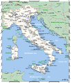
Italy's cities and main towns.

Astronaut photograph highlighting the night-time appearance of southern Italy.
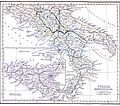
Southern Italy and Sicily on the 1849 map.
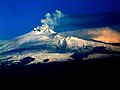
Etna, the highest active volcano in Europe.

Asinara island with the Aragonese Torre della Pelosa (16th century), Sardinia.
The coastal areas of Liguria have a Mediterranean climate.

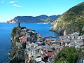
Landscape of Tuscany.

Rice paddies in the Po Valley near Vercelli.

Marmore waterfall, the world's tallest man-made waterfall, was created by the ancient Romans.

Mount Vesuvius looms over the ruins of Pompeii.
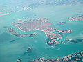
Panorama of Venice and its lagoon.

The Karst Plateau drops vertically into the Adriatic Sea near Trieste.

Gran Sasso d'Italia, the highest peak of the Apennines.

Vineyards in the Montferrat hills, with the Monviso in the background.

Livigno, the tallest 'comune' of Italy, during winter.

The Strait of Messina as seen from mainland.

'La Canna' rock off the coast of Filicudi.

Southern coast of Sardinia.
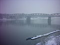
The Po river at Cremona, in a foggy winter day.


See also[]
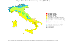
- Climate of Italy
- List of islands of Italy
- Natural hazards in Italy
Notes[]
- ^ 2006 estimates.
References[]
- ^ a b c Riganti], [dir. da Alberto (1991). Enciclopedia universale Garzanti (Nuova ed. aggiornata e ampliata. ed.). Milano: Garzanti. ISBN 88-11-50459-7.
- ^ "Analisi dei cambiamenti della copertura ed uso del suolo in Italia nel periodo 2000-2006" (PDF). ISPRA. Archived from the original (PDF) on 26 April 2012. Retrieved 23 November 2011.
![]() This article incorporates public domain material from the CIA World Factbook website https://www.cia.gov/the-world-factbook/.
This article incorporates public domain material from the CIA World Factbook website https://www.cia.gov/the-world-factbook/.
Italy articles | ||||||||||||||
|---|---|---|---|---|---|---|---|---|---|---|---|---|---|---|
| History |
|  | ||||||||||||
| Geography | ||||||||||||||
| Politics |
| |||||||||||||
| Economy |
| |||||||||||||
| Society |
| |||||||||||||
| ||||||||||||||
- Geography of Italy
- Geology of Italy