Geography of Germany
 | |
| Continent | Europe |
|---|---|
| Region | Central Europe |
| Coordinates | 51°00′N 10°00′E / 51.00°N 10.00°E |
| Area | Ranked 62nd |
| • Total | 357,021 km2 (137,847 sq mi) |
| • Land | 97.66% |
| • Water | 2.34% |
| Coastline | 2,389 km (1,484 mi) |
| Borders | 3,714 km (2,307 mi) Border lengths included
|
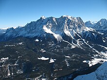
| Highest point | Zugspitze, 2,962.06 m (9,718 ft) |
| Lowest point | −3.54 m[citation needed] |
| Longest river | Rhine, 1,230 km (764 mi) |
| Largest lake | Lake Constance 536 km2 (207 sq mi)[1] |
| Climate | temperate |
| Terrain | lowlands in north; uplands in center; Alps in south |
| Natural resources | coal, lignite, natural gas, iron ore, copper, nickel, uranium, potash, salt, construction materials, timber, arable land |
| Natural hazards | flooding and earthquake in Rhineland-Palatinate, North Rhine-Westphalia and Baden-Württemberg. landslide |
| Exclusive economic zone | 57,485 km2 (22,195 sq mi) |


Germany (German: Deutschland) is a country in Central Europe, that stretches from the Alps, across the North European Plain to the North Sea and the Baltic Sea. It is the second-most populous country in Europe after Russia, and is seventh-largest country by area in the continent. The territory of Germany covers 357,021 km2 (137,847 sq mi), consisting of 349,223 km2 (134,836 sq mi) of land and 7,798 km2 (3,011 sq mi) of waters.
Elevation ranges from the mountains of the Alps (highest point: the Zugspitze at 2,962 metres (9,718 ft)) in the south to the shores of the North Sea (Nordsee) in the northwest and the Baltic Sea (Ostsee) in the northeast. Between lie the forested uplands of central Germany and the low-lying lands of northern Germany (lowest point: Neuendorf-Sachsenbande at 3.54 metres (11.6 ft) below sea level), traversed by some of Europe's major rivers such as the Rhine, Danube and Elbe.[2]
Germany has the second-most borders of any European country, after Russia. It shares borders with nine countries: Denmark in the north, Poland and the Czech Republic in the east, Switzerland (its only non-EU neighbor) and Austria in the south, France in the southwest and Belgium, Luxembourg and the Netherlands in the west. Germany also shares a maritime border with Sweden in the north and the United Kingdom in the northwest.
Area[]
Germany is in Central Europe, bordering Denmark in the north, Poland and the Czech Republic in the east, Austria and Switzerland in the south, France and Luxembourg in the south-west, and Belgium and the Netherlands in the north-west. It lies mostly between latitudes 47° and 55° N (the tip of Sylt is just north of 55°), and longitudes 5° and 16° E. The territory covers 357,021 km2 (137,847 sq mi), consisting of 349,223 km2 (134,836 sq mi) of land and 7,798 km2 (3,011 sq mi) of water. It is the seventh largest country by area in Europe and the 63rd largest in the world.[2]
Extreme points[]
- Northernmost point: List, Sylt, Schleswig-Holstein 55°03′N 8°24′E / 55.050°N 8.400°E
- Northernmost point in mainland Germany: Rodenäs, Schleswig-Holstein 54°54′N 8°49′E / 54.900°N 8.817°E
- Southernmost point: Haldenwanger Eck, Oberstdorf, Bavaria 47°16′12.39″N 10°10′41.95″E / 47.2701083°N 10.1783194°E
- Westernmost point: Isenbruch, Selfkant, North Rhine-Westphalia 51°3′N 5°52′E / 51.050°N 5.867°E
- Easternmost point: Deschka, Neißeaue, Saxony 51°16′N 15°2′E / 51.267°N 15.033°E
- Lowest point (man-made): Tagebau Hambach 293 m (961 ft) below sea level, Niederzier, North Rhine-Westphalia, 50°54′39″N 6°30′10″E / 50.91083°N 6.50278°E
- Lowest point (natural): Neuendorf-Sachsenbande, Wilstermarsch, Schleswig-Holstein 3.54 m (11.6 ft) below sea level[3] 53°57′48″N 9°19′5″E / 53.96333°N 9.31806°E
- Highest point: Zugspitze, in the Bavarian Alps, 2,962 m (9,718 ft), Garmisch-Partenkirchen / Grainau, Bavaria 47°25′N 10°59′E / 47.417°N 10.983°E
- Highest settlement: Feldberg, Baden-Württemberg, in the Black Forest, 1,277 m (4,190 ft)
Maritime claims[]
- Continental shelf: 200 m (660 ft) depth or to the depth of exploitation
- Exclusive economic zone: 57,485 km2 (22,195 sq mi) with 200 nmi (370.4 km; 230.2 mi). The exact EEZ is due to conventions with neighbouring states.
- Territorial sea: 12 nmi (22.2 km; 13.8 mi)
Physical geography[]

The northern third of the country lies in the North European Plain, with flat terrain crossed by northward-flowing watercourses (Elbe, Ems, Weser, Oder). Wetlands and marshy conditions are found close to the Dutch border and along the Frisian coast. Sandy Mecklenburg in the northeast has many glacier-formed lakes dating to the last glacial period.
Moving south, central Germany features rough and somewhat patternless hilly and mountainous countryside, some of it formed by ancient volcanic activity. The Rhine valley cuts through the western part of this region. The central uplands continue east and north as far as the Saale and merge with the Ore Mountains on the border with the Czech Republic. Upland regions include the Eifel, Hunsrück and Palatine Forest west of the Rhine, the Taunus hills north of Frankfurt, the Vogelsberg massif, the Rhön, and the Thüringer Wald. South of Berlin, the east-central part of the country is more like the low northern areas, with sandy soil and river wetlands such as the Spreewald region.
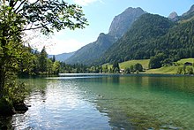
Southern Germany's landforms are defined by various linear hill and mountain ranges like the two adjacent ranges of the Swabian and Franconian Alb (reaching approximately from the source of the Danube in the southwest of Baden-Württemberg, south of Stuttgart, across Swabia into Central Franconia and to the valley of the river Main) and the Bavarian Forest along the border between Bavaria and the Czech Republic. The Alps on the southern border are the highest mountains, but relatively little Alpine terrain lies within Germany (in southeastern Swabia and Upper Bavaria) compared to Switzerland and Austria. The Black Forest, on the southwestern border with France, separates the Rhine from the headwaters of the Danube on its eastern slopes.
Climate[]


The north–south difference in Germany, between 55°03"N (at List on Sylt) and 47°16"N (around Oberstdorf, Bavaria) equals almost eight degrees of latitude (or 889 km), but this cannot largely be seen in different average temperatures. Instead, there is a stronger west–east cline in temperature. This is explained by the North's flat and open landscapes and its closeness to the sea, and South's higher terrain, larger distance from the sea, and the Alps. These mountains prevent much of the usually warmer Mediterranean air blowing into southern Germany. To the north of the Alps and the Carpathians, the local climate becomes colder, even at the same latitude and altitude. This is caused by some areas being further away from the Atlantic Ocean's Gulf Stream, known for having a warm current for its latitude, in addition to being closer to Russia's and Siberia's extremely cold winter winds. Even if Siberian winter winds are not dominating, when they do hit Germany, temperatures can in extreme cases fall to -30 C and below during the nights, and this has an effect on the average temperatures of November to March. Although rare, when such cold air reaches Germany, the Eastern parts becomes more affected compared to the Western parts. These factors results in Hamburg in the North having the same annual average temperature as Munich in the South. The annual average temperature in Hamburg is +9.5 C and +9.7 in Munich[4] whilst Berlin has an annual average temperature of +9.9 C.[5]
The warmest area in Germany is the area bordering France, west of the Schwarzwald hills, roughly between Karlsruhe to the north and the Swiss border to the south. The coldest area (except for mountain peaks) is found in the southeastern parts of eastern Germany around Dresden and Görlitz, only about two latitudes higher. The difference in the annual average base is not extreme. Freiburg im Breisgau (located a little south of Karlsruhe) has an average annual temperature of +11.4 C. Görlitz has an equal value of +8.8 C, a difference of 2.6 C.[6] Colder meteorological stations in Germany can be found, but mainly at notably higher altitudes.
Germany's climate is temperate and marine, with cold, cloudy winters and warm summers and in the south occasional warm föhn wind. The greater part of Germany lies in the cool/temperate climatic zone in which humid westerly winds predominate. In the northwest and the north, the climate is oceanic and rain falls all the year round. Winters there are relatively mild and summers comparatively cool. In the east, the climate shows clear continental features; winters can be very cold for long periods, and summers can become very warm. Dry periods are often recorded.
In the center and the south, there is a transitional climate which may be predominantly oceanic or continental, according to the general weather situation. Winters are cool and summers warm, though maximum temperatures can exceed 30 °C (86 °F) for several days in a row during heat waves. The warmest regions of Germany can be found in the southwest (see rhine rift, German Wine Route and Palatinate). Here summers can be hot with many days exceeding 30 °C (86 °F). Sometimes, minimum temperatures do not drop below 20 °C (68 °F), which is relatively rare in other regions.[7][8]
Though the German climate is rarely extreme, there are occasional spikes of cold or heat. Winter temperatures can sometimes drop to two-digit negative temperatures for a few days in a row. Conversely, summer can see periods of very high temperatures for a week or two. The recorded extremes are a maximum of 38.6 °C (101.5 °F) (July 2019, Lingen),[9] and a minimum of −37.8 °C (−36.0 °F) (February 1929, in Pfaffenhofen an der Ilm).[10]
Land use of Germany[]
Germany covers a total of 357,021 km2 (137,847 sq mi), of which 5,157 km2 (1,991 sq mi) is irrigated land and 8,350 km2 (3,220 sq mi) is covered by water, the largest lakes being Lake Constance (total area of 536 km2 (207 sq mi), with 62% of the shore being German; international borders are not defined on the lake itself), Müritz (117 km2 or 45 sq mi) and Chiemsee (80 km2 or 31 sq mi). The majority of Germany is covered by either arable land (33.95%); permanent crops cover 0.57% of the land.
Germany has a total of 2,389 km (1,484 mi) of coastline, and borders totaling 3,714 km (2,308 mi) (clockwise from north: Denmark 140 km (87 mi), Poland 467 km (290 mi), Czech Republic 704 km (437 mi),[11] Austria 801 km (498 mi), Switzerland 348 km (216 mi), France 418 km (260 mi), Luxembourg 128 km (80 mi), Belgium 133 km (83 mi), Netherlands 575 km (357 mi)). The German-Austrian border crosses itself near Jungholz. The border with Belgium includes 5 German exclaves because the Vennbahn railway is on Belgian territory crossing in and out of Germany.
Rivers[]
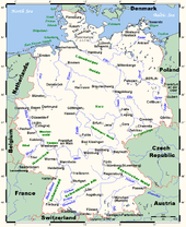
The main rivers in Germany are:
- The Rhine (Rhein in German) with a German section extending 865 km (537 mi) (main tributaries including the Neckar, the Main and the Moselle (Mosel));
- The Elbe with a German section of 727 km (452 mi) (also drains into the North Sea); and
- The Danube (Donau) with a German length of 687 km (427 mi).
Further important rivers include the Saale and the Main in central Germany, the Neckar in the southwest, the Weser in the North and the Oder at the eastern border.
Caves[]

Throughout the Karst rocks many caves were formed especially in the valley of the Hönne. The biggest culture cave of Europe is located in Balve.
Tidal Flats[]
A recent global remote sensing analysis suggested that there were 2,783km² of tidal flats in Germany, making it the 11th ranked country in terms of how much tidal flat occurs there. [12]
Natural resources[]
- Iron ore, coal, potash, timber, lignite, uranium, copper, petroleum, natural gas, salt, nickel, and water.
Environment[]
- Current issues
- Emissions from coal-burning utilities and industries contribute to air pollution; acid rain, resulting from sulphur dioxide emissions, is damaging forests in Germany; pollution in the Baltic Sea from raw sewage and industrial effluents from rivers in eastern Germany; hazardous waste disposal; government (under Chancellor Schröder, SPD) announced intent to end the use of nuclear power for producing electricity; government working to meet EU commitment to identify nature preservation areas in line with the EU's Flora, Fauna, and Habitat directive. Germany's last glacier is disappearing.[citation needed]
- International agreements
- Party to: Air Pollution, Air Pollution-Nitrogen oxides, Air Pollution-Persistent Organic Pollutants, Air Pollution-Sulphur 85, Air Pollution-Sulphur 94, Air Pollution-Volatile Organic Compounds, Antarctic-Environmental Protocol, Antarctic Treaty, Biodiversity, Climate Change, Climate Change-Kyoto Protocol, Desertification, Endangered Species, Environmental Modification, Hazardous Wastes, Law of the Sea, Marine Dumping, Nuclear Test Ban, Ozone Layer Protection, Ship Pollution, Tropical Timber 83, Tropical Timber 94, Wetlands, Whaling
- Signed, but not ratified: none
- Natural hazards
- Flooding through rivers after heavy rainfall, such as during the 2002 European floods, or storm surge, such as the North Sea flood of 1962 and the historic floods of 1362 and 1634 that changed the coastline of what is now the west coast of Schleswig-Holstein.
Flora and fauna[]

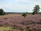
Phytogeographically, Germany is shared between the Atlantic European and Central European provinces of the Circumboreal Region within the Boreal Kingdom. The territory of Germany can be subdivided into two ecoregions: European-Mediterranean montane mixed forests and Northeast-Atlantic shelf marine.[13] The majority of Germany is covered by either arable land (33%) or forestry and woodland (31%). Only 15% is covered by permanent pastures.
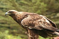
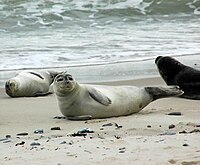
Plants and animals are those generally common to middle Europe. Beeches, oaks, and other deciduous trees constitute one-third of the forests; conifers are increasing as a result of reforestation. Spruce and fir trees predominate in the upper mountains, while pine and larch are found in sandy soil. There are many species of ferns, flowers, fungi, and mosses. Fish abound in the rivers and the North Sea. Wild animals include deer, wild boar, mouflon, fox, badger, hare, and small numbers of beaver. Various migratory birds cross Germany in the spring and autumn.
The national parks in Germany include the Wadden Sea National Parks, the Jasmund National Park, the Vorpommern Lagoon Area National Park, the Müritz National Park, the Lower Oder Valley National Park, the Harz National Park, the Saxon Switzerland National Park and the Bavarian Forest National Park.
Germany is known for its many zoological gardens, wildlife parks, aquaria, and bird parks.[14] More than 400 registered zoos and animal parks operate in Germany, which is believed to be the largest number in any single country of the world.[15] The Zoologischer Garten Berlin is the oldest zoo in Germany and presents the most comprehensive collection of species in the world.[16]
Human geography[]
Demographics[]

With an estimated 83.2 million inhabitants in December 2020, Germany is the most populous country in the European Union and ranks as the 19th largest country in the world in terms of population. Its population density stands at 233 inhabitants per square kilometre (600/sq mi). The United Nations Population Fund lists Germany as host to the second-highest number of international migrants worldwide,[17] around 25% of Germany's population do not hold a German passport or are direct descendants of immigrants. The number of third and subsequent generations of immigrants are not statistically recorded.
Administrative divisions[]
Germany comprises sixteen states that are collectively referred to as Länder.[18] Each state has its own state constitution[19] and is largely autonomous in regard to its internal organisation. Due to differences in size and population the subdivision of these states varies, especially between city states (Stadtstaaten) and states with larger territories (Flächenländer). For regional administrative purposes five states, namely Baden-Württemberg, Bavaria, Hesse, North Rhine-Westphalia and Saxony, consist of a total of 22 Government Districts (Regierungsbezirke). As of July 2021 Germany is divided into 400 districts (Kreise) on municipal level, these consist of 294 rural districts and 106 urban districts.[20][21]
Anhalt
Westphalia
|
Urbanization[]
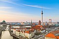
Germany has a number of large cities; the most populous are: Berlin, Hamburg, Munich, Cologne, Frankfurt, and Stuttgart. The largest conurbation is the Rhine-Ruhr region (12 million), including Düsseldorf (the capital of North Rhine-Westphalia), Cologne, Essen, Dortmund, Duisburg, and Bochum.
| Rank | Name | State | Pop. | Rank | Name | State | Pop. | ||
|---|---|---|---|---|---|---|---|---|---|
 Berlin  Hamburg |
1 | Berlin | Berlin | 3,644,826 | 11 | Bremen | Bremen | 569,352 | 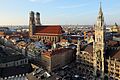 Munich 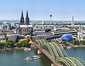 Cologne |
| 2 | Hamburg | Hamburg | 1,841,179 | 12 | Dresden | Saxony | 554,649 | ||
| 3 | Munich | Bavaria | 1,471,508 | 13 | Hannover | Lower Saxony | 538,068 | ||
| 4 | Cologne | North Rhine-Westphalia | 1,085,664 | 14 | Nuremberg | Bavaria | 518,365 | ||
| 5 | Frankfurt | Hesse | 753,056 | 15 | Duisburg | North Rhine-Westphalia | 498,590 | ||
| 6 | Stuttgart | Baden-Württemberg | 634,830 | 16 | Bochum | North Rhine-Westphalia | 364,628 | ||
| 7 | Düsseldorf | North Rhine-Westphalia | 619,294 | 17 | Wuppertal | North Rhine-Westphalia | 354,382 | ||
| 8 | Leipzig | Saxony | 587,857 | 18 | Bielefeld | North Rhine-Westphalia | 333,786 | ||
| 9 | Dortmund | North Rhine-Westphalia | 587,010 | 19 | Bonn | North Rhine-Westphalia | 327,258 | ||
| 10 | Essen | North Rhine-Westphalia | 583,109 | 20 | Münster | North Rhine-Westphalia | 314,319 | ||
See also[]
- Administrative divisions of Germany
- Geography of Europe
- Geology of Germany
- List of islands of Germany
- List of national parks of Germany
References[]
- ^ "The Complete Guide To: Lake Constance". The Independent. September 17, 2011.
- ^ Jump up to: a b "Germany". CIA World Factbook. Central Intelligence Agency. November 14, 2006. Archived from the original on September 30, 2006. Retrieved November 29, 2006.
- ^ "Geografie" (PDF). Statistische Jahrbuch Schleswig-Holstein (in German). Hamburg: Statistisches Amt für Hamburg und Schleswig-Holstein. 2019/2020: 307. 2020. ISSN 0487-6423. Retrieved 2020-09-08.
- ^ See "HAMBURG-FUHLS.(FLUGWEWA)", "HAMBURG-NEUWIEDENTHAL" and "HAMBURG-WANDSBEK" (for Hamburg)- altitudes are 3,11 and 18 meters; and "MUENCHEN-STADT (WST)" for Munich - altitude is 515 meters, at [1]
- ^ See "BERLIN-TEMP. (WST)" (altitude 48 meters) at
- ^ See "FREIBURG I.BR. (AWST)" (altitude 236 meters) and "GOERLITZ (WEWA)" (altitude 238 meters) at [2]
- ^ German Climate Handbuch Deutschland. Retrieved November 30, 2006.
- ^ "German Climate and Weather". World Travels. Globe Media Ltd. 2014. Retrieved November 30, 2006.
- ^ "Hitzewelle Juli 2019 in Westeuropa – neuer nationaler Rekord in Deutschland". 1 August 2019. Retrieved 28 September 2019.
- ^ "Wetterrekorde Deutschland". wetterdienst.de. Retrieved 8 May 2018.
- ^ "CIA – The World Factbook – Germany". The World Factbook. Central Intelligence Agency. April 26, 2015. Retrieved 2015-04-26.
- ^ Murray, N.J.; Phinn, S.R.; DeWitt, M.; Ferrari, R.; Johnston, R.; Lyons, M.B.; Clinton, N.; Thau, D.; Fuller, R.A. (2019). "The global distribution and trajectory of tidal flats". Nature. 565: 222–225. doi:10.1038/s41586-018-0805-8.
- ^ List of Ecoregions: Terrestrial Ecoregions WWF. Retrieved 21 November 2000.
- ^ List of famous Zoological gardens in European countries www.eupedia.com. Retrieved 17 October 2008.
- ^ Some interesting zoo facts www.americanzoos.info/. Retrieved 17 October 2008.
- ^ (in German)Tierstatistik 2008, Zoo Berlin. Retrieved 19 November 2009. Archived June 9, 2010, at the Wayback Machine
- ^ "International Migrant Stock 2020". UN Department of Economic and Social Affairs. Retrieved 15 July 2021.
- ^ The individual denomination is either Land [state], Freistaat [free state] or Freie (und) Hansestadt [free (and) Hanseatic city].
"The Federal States". www.bundesrat.de. Bundesrat of Germany. Retrieved 17 July 2011.
"Amtliche Bezeichnung der Bundesländer" [Official denomination of federated states] (PDF; download file „Englisch“). www.auswaertiges-amt.de (in German). Federal Foreign Office. Retrieved 22 October 2011. - ^ "Example for state constitution: "Constitution of the Land of North Rhine-Westphalia"". Landtag (state assembly) of North Rhine-Westphalia. Archived from the original on 17 January 2013. Retrieved 17 July 2011.
- ^ "Kreise und kreisfreie Städte zur Europawahl 2019" (in German). Federal_Returning_Officer Deutschland. May 2019. Retrieved 15 July 2021.
- ^ "Fusion der Stadt Eisenach mit dem Wartburgkreis 01.07.2021" (in German). City Eisenach. 1 July 2021. Retrieved 15 July 2021.
- ^ "Bevölkerung nach Nationalität und Bundesländern am 31.12.2020" (in German). Statistisches Bundesamt Deutschland. 21 June 2021. Retrieved 15 July 2021.
External links[]
| Wikimedia Commons has media related to Geography of Germany. |
- Kostenlose Deutschland-Karten
- Geoberg.de: Geologie Deutschlands – Fotografien geologischer Objekte aus Deutschland
- mineralienatlas.de: Reiches Erz aus dem Harz
- Deutscher Klimaatlas
- Geography of Germany – Encyclopedia of World Geography
| show The Danube |
|---|

- Geography of Germany