Geography of Malta
This article was imported from the CIA World Factbook and may require rewriting and/or reformatting to meet Wikipedia's quality standards. |


The geography of Malta is dominated by water. Malta is an archipelago of coralline limestone, located in the Mediterranean Sea, 81 kilometres south of Sicily, Italy,[1] and nearly 300 km north (Libya) and northeast (Tunisia) of Africa. Although Malta is situated in Southern Europe, it is located farther south than Tunis, capital of Tunisia, Algiers, capital of Algeria, Tangier in Morocco and also Aleppo in Syria, and Mosul in Iraq in the Middle East. Only the three largest islands – Malta, Gozo and Comino – are inhabited. Other (uninhabited) islands are: Cominotto, Filfla and the St.Paul's Islands. The country is approximately 316 km2 (122 sq mi) in area. Numerous bays along the indented coastline of the islands provide harbours. The landscape of the islands is characterised by high hills with terraced fields. The highest point, at 253 metres, Ta' Zuta on mainland Malta. The capital is Valletta.
Geographic coordinates: 35°50′N 14°35′E / 35.833°N 14.583°E
 WikiMiniAtlas
Statistics[]
Malta has a total area of 315.718 km2,[2] with land making up 315.718 km2 and water taking up zero area. Compared to other political entities, this makes Malta:
- (Australia) slightly less than one-seventh the Australian Capital Territory's size;
- (Canada) roughly one-eighteenth Prince Edward Island's size;
- (UK) slightly smaller than the Isle of Wight;
- (US) slightly less than twice the size of Washington, DC.
Excluding 56 km from the island of Gozo, Malta has a coastline of 196.8 km. Its maritime claims of territorial sea are 12 nmi (22.2 km; 13.8 mi), contiguous zone is 24 nmi (44.4 km; 27.6 mi), continental shelf is 200 m depth or to the depth of exploitation, and Malta's exclusive fishing zone spans 25 nmi (46.3 km; 28.8 mi).
Islands[]
| Name | Area | Note/ coordinates |
Image |
|---|---|---|---|
| Malta Island | 246 km²[2] | 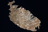
| |
| Gozo (Għawdex) |
67.1 km²[2] | 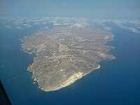
| |
| Comino (Kemmuna) |
2.8 km²[2] | 
| |
| Manoel Island (Il-Gżira Manoel) |
0.3 km² | 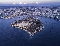
| |
| St Paul's Islands (Il-Gżejjer ta' San Pawl) |
0.101 km²[2] | 
| |
| Cominotto (Kemmunett) |
0.099 km²[3] | 
| |
| Filfla (and Filfoletta) | 0.020 km²[2] | 
| |
| Fungus Rock (Il-Ġebla tal-Ġeneral) |
0.007 km²[2] | 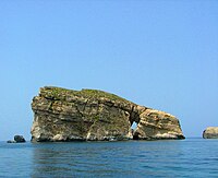
| |
| Ħalfa Rock (Il-Ġebla tal-Ħalfa) |
0.0050 km²[4][5] | Situated near Gozo. In the island there is 4 to 5 metres deep water rock pool just 2 metres above sea level, possibly man made due to its perfectly round shape. There is also an underground fresh water system which emerges from a small cave. Most of the plants occurs on the western part of the island. , , Lygeum spartum, , Thymbra capitata, Teucrium fruticans, , , Bromus madritensis, Capparis spinosa, , Pallenis spinosa, , , .[3] | 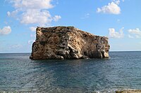
|
| Old Battery's Rock (Ġebla ta' taħt il-Batterija) |
Situated on the southeast of Comino. Flora consisted of 22 individuals of Inula crithmoides (2010).[3] | ||
| Lantern Point Rock (Ġebla Tal-Ponta Rqiqa) |
Situated near Comino.[3] Live here two species of plants: and Inula crithmoides. It has a height of 7 meters.[6] | 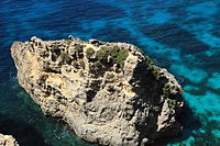
| |
| Large | In island, there is a cave. Species of plants: , Daucus carota, , , Arthrocnemum macrostachyum, Senecio bicolor.[3] | 
| |
| Small | Situated between Large Blue Lagoon and Cominotto. Species of plants: Arthrocnemum macrostachyum, Daucus carota, Lygeum spartum, Lavatera arborea.[3] | 
| |
| Devil's End Rock (Il-Ġebla tax-Xifer l-Infern)[3] |
Situated near main island, Delimara point. | 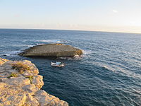
| |
| Għallis Rocks[3] | 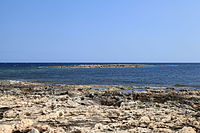
| ||
| Taċ-Ċawl Rock (Il-Ġebla taċ-Ċawl) |
Situated near Gozo. The flora consisted of Lygeum spartum, Asphodelus aestivus, Crithmum maritimum, , , Opuntia, Thymbra capitata, , Foeniculum vulgare, Allium commutatum, , Bromus madritensis, Capparis spinosa, , Pistacia lentiscus, , , Sonchus tenerrimus, , .[3] | ||
| Cheirolophus Rock (Ħaġra tas-Sajjetta) |
Situated near main island. It has a height of 9 to 12 meters high at its highest point. Species of plants: , Crithmum maritimum, Cheirolophus crassifolius, Inula crithmoides, , Daucus carota, Cheirolophus crassifolius.[3] | ||
| Barbaganni Rock | Situated near Gozo. No soil exists on the islet because island is inundated by water wave action during rough weather. The flora consisted of only 14 individuals of Inula crithmoides (2010).[3] | ||
| Crocodile Rock & Bear rocks (Il-Ġebla tal-Baqra u il-Ġebel tal-Orsijiet) |
Near Gozo, three rocks in total.[3] | ||
(Ta' Fra Ben islet, Il-Ponta jew Ras il- Qawra) |
Situated near main island. The western part is littered with small boulders, while much of the vegetation occurs in the middle part of the islet. In island there is sea cave occurs as a big hole in the middle of the islet. Species of plants: Arthrocnemum macrostachyum, , Inula crithmoides, , Limonium, .[3] | 
| |
| Comino Cliff Face Rock (Ta' Taħt il-Mazz Rock) |
Situated near Comino. The island is very steep - cliffs. The majority of species of plants occur on its west side, while only one species of plant inhabits its east side. Species of plants: Matthiola incana, Inula crithmoides, , Daucus carota, , Anthyllis hermanniae, Pistacia lentiscus.[3] | ||
| Xrobb l-Għaġin Rock (It-Taqtiegħa)[3] |
|||
| Fessej Rock (Il-Ġebla tal-Fessej)[3][7] |

| ||
| Għemieri Rocks (L-iskolli tal-Għemieri)[3] |
|||
| Ħnejja Rocks (Ġebel tal-Ħnejja)[3] |
|||
| White Rock / Blue Islets (Rocks) (Ġebla tal-Għar Qawqla)[3] |

|
Climate[]
Mediterranean with mild, rainy winters and hot, dry summers.
Elevation extremes[]
The lowest point is the Mediterranean Sea at 0 m and the highest point is Ta' Dmejrek at 253 m.
Land use[]
- Arable land: 28.12%
- Permanent crops: 4.06%
- Other: 67.81% (2011)
Irrigated land[]
32 km2 (2007)
Total renewable water resources[]

0.05 km3 (2011)
Environment[]
Current issues[]
Limited natural fresh water resources; increasing reliance on desalination.
International Agreements[]
- Party to: Air Pollution, Biodiversity, Climate Change, Climate Change-Kyoto Protocol, Desertification, Endangered Species, Law of the Sea, Marine Dumping, Ozone Layer Protection, Ship Pollution, Wetlands
signed, but not ratified:
References[]
- ^ From Żebbuġ in Malta, coordinates: 36°04'48.2"N 14°15'06.7"E to Cava d'Aliga (Scicli) in Italy, coordinates: 36°43'22.5"N 14°41'10.9"E – Google Maps
- ^ Jump up to: a b c d e f g State of the Environment Report for Malta 1998 Archived 2015-04-02 at the Wayback Machine
- ^ Jump up to: a b c d e f g h i j k l m n o p q r s "Topography and Flora of the Satellite islets surrounding the Maltese Archipelago" - Arnold Sciberras, Jeffrey Sciberras, 2010
- ^ Il-Gebla tal-Halfa - Malta Environment & Planning Authority (MEPA)
- ^ Site factsheet for Il-Gebla tal-Halfa - EUNIS
- ^ "A contribution to the knowledge of the terrestrial Mammalian fauna of Comino and its satellite islets (Maltese Archipelago)" - Biodiversity Journal, 2012, 3 (3): 191-200
- ^ Caruana, Joseph (2011). "Toponomi t'Għajnsielem (1)" (PDF). L-Imnara. Rivista tal-Għaqda Maltija tal-Folklor. 9 (4): 189. Archived from the original (PDF) on 18 April 2016.

- Geography of Malta