Geography of Ukraine
This article needs additional citations for verification. (July 2017) |
 | |
| Continent | Europe |
|---|---|
| Region | Eastern Europe |
| Coordinates | 50°27′N 30°30′E / 50.450°N 30.500°E |
| Area | Ranked 45th |
| • Total | 603,500 km2 (233,000 sq mi) |
| • Land | 95.99% |
| • Water | 4.01% |
| Coastline | 2,782 km (1,729 mi) |
| Borders | 4,558 km2 (1,760 sq mi) |
| Highest point | Hoverla 2,061 metres (6,762 ft) |
| Lowest point | Kuyalnik Estuary −5 metres (−16 ft) |
| Longest river | Dnieper 981 kilometres (610 mi) |
| Largest lake | Lake Yalpuh 149 km2 (57.53 sq mi) |
| Exclusive economic zone | 147,318 km2 (56,880 sq mi) |

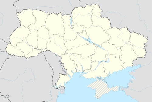


The geography of Ukraine varies greatly from one region of the country to another, with the majority of the country lying within the East European Plain. Ukraine is the second-largest country by area in Europe (after the Russian Federation). Its various regions have diverse geographic features ranging from highlands to lowlands, as well as climatic range and a wide variety in hydrography.
Geographic location[]
Ukraine has a strategic position in Eastern Europe: lying on the northern shores of the Black Sea and the Sea of Azov, it borders a number of European countries - Poland, Slovakia and Hungary in the west, Belarus in the north, Moldova and Romania in the south-west and Russia in the east. The total geographic area of Ukraine is 603,550 square kilometers (233,030 sq mi). Ukraine has an Exclusive Economic Zone of 147,318 km2 (56,880 sq mi) in the Black Sea.
The land border of Ukraine totals 6,993 kilometers (4,345 mi).[1] The border lengths with each country are: Belarus 891 kilometers (554 mi), Hungary 103 kilometers (64 mi), Moldova 939 kilometers (583 mi), Poland 428 kilometers (266 mi), Romania 169 kilometers (105 mi) on the south and 362 kilometers (225 mi) on the west, Russia 1,974 kilometers (1,227 mi), and Slovakia 90 kilometers (56 mi). Ukraine is also bordered by 3,783 kilometers (2,351 mi) of coastline. The border with Russia is the country's longest border - it runs in part through the Sea of Azov.
The village of Vel'ké Slemence (Ukrainian: ) (Hungarian: Szelmenc) is an anomaly, as it's a village with a majority of Hungarians, but it's split between Slovakia and Ukraine.
Relief[]

Most of its territory lies within the Great European Plain, while parts of western regions and southern regions lay within the . In general Ukraine comprises two different biomes: mixed forest towards the middle of continent and steppe towards the Black Sea littoral. Major provinces include, Polesian Lowland, Dnieper Lowland, Volhynia-Podolie Plateau, Black Sea-Azov Lowland, Donets-Azov Plateau, Central Russian Upland, Carpathians, and Pannonian Basin.
The western regions feature an alpine-like section of Carpathian Mountains, the Eastern Carpathians that stretches across Poland, Ukraine and Romania. The highest peak is Hoverla, which is 2,061 metres (6,762 ft) tall. Mountains are limited to the west, the southern tip of Ukraine on the Sea of Azov. The western region has the Carpathian Mountains, and some eroded mountains from the Donets Ridge are in the east near the Sea of Azov. The highest elevation in Ukraine is located at the peak of Mount Hoverla which is 2,061 meters (6,762 ft) above sea level.
Most of Ukraine's area is taken up by the steppe-like region just north of the Black Sea. Most of Ukraine consists of fertile plains (or steppes) and plateaus. In terms of land use, 58% of Ukraine is considered arable land; 2% is used for permanent crops, 13% for permanent pastures, 18% is forests and woodland, and 9% is other.
Physiographic division of Ukraine[]
Most of Ukraine consists of regular plains with the average height above sea level being 175 metres (574 ft). It is surrounded by mountains to its west and extreme south. Wide spaces of the country's plains are located in the south-western part of the East European Plain. The plains have numerous highlands and lowlands caused by the uneven crystallized base of the East European craton. The highlands are characterized by Precambrian basement rocks from the Ukrainian Shield.
Plains are considered elevations of no more than 0–600 m (0–1,969 ft) among which there are recognized lowlands (plains) and uplands (plateaus, ridges, hill ridges).
Great European Plain (subregion East European Plain)[]
- Volhynia-Podillia Upland (Volhynia-Podillia Plateau)
- Volhynian Upland
- Podolian Upland
- Small Polesia Plain
- Khotyn Upland (part of Moldavian Plateau)
- Roztocze
- Sian-Dniester Lowland
- Eastern Carpathian Foothills
- Polesian Lowland
- Dnieper Upland
- Dnieper Lowland
- Central Russian Upland
- Donets-Azov Plateau
- Azov Upland
- Donets Ridge
- Black Sea-Azov Lowland
Alpine system[]
- Transcarpathian Lowland (extension of Great Hungarian Plain, part of Eastern Pannonian Basin)
- Eastern Carpathians (part of Carpathian Mountains)
- Outer Eastern Carpathians (more Eastern Beskids and the Ukrainian Carpathians)
- Inner Eastern Carpathians (more Vihorlat-Gutin Area)
- Crimean Mountains
Hydrography[]

The territory of Ukraine is bordered by the waters of the Black Sea and the Sea of Azov. More than 95% of the rivers are part of those two seas' drainage basins. A few rivers are part of the Baltic Sea basin. There are seven major rivers in Ukraine: Desna, Dnipro, Dnister, Danube, Prypiat, Siverian Donets, and Southern Buh.
Climate[]
Ukraine has a mostly temperate climate, with the exception of the southern coast of Crimea which has a subtropical climate.[2] The climate is influenced by moderately warm, humid air coming from the Atlantic Ocean.[3] Average annual temperatures range from 5.5–7 °C (41.9–44.6 °F) in the north, to 11–13 °C (51.8–55.4 °F) in the south.[3] Precipitation is disproportionately distributed; it is highest in the west and north and lowest in the east and southeast.[3] Western Ukraine, particularly in the Carpathian Mountains receive around 1,200 millimetres (47.2 in) of precipitation annually, while Crimea and the coastal areas of the Black Sea receive around 400 millimetres (15.7 in).[3]
| Location | July (°C) | July (°F) | January (°C) | January (°F) |
|---|---|---|---|---|
| Kyiv | 25/16 | 78/61 | -5/- 46 | 30/21 |
| Kharkiv | 26/16 | 79/61 | -7/-31 | 28/19 |
| Dnipro | 28/18 | 83/65 | 0/−5 | 32/21 |
| Odesa | 27/18 | 80/65 | 2/−2 | 36/27 |
| Donetsk | 27/16 | 81/61 | –1/–6 | 29/20 |
| Zaporizhzhia | 28/16 | 83/61 | –0/−5 | 31/21 |
| Lviv | 24/13 | 75/56 | -1/-8 | 32/21 |
Natural resources[]
Significant natural resources in Ukraine include: iron ore, coal, manganese, natural gas, oil, salt, sulfur, graphite, titanium, magnesium, kaolin, nickel, mercury, and arable land.
Environmental issues[]
Ukraine does have many environmental concerns. Some regions lack adequate supplies of potable water. Air and water pollution affects the country, as well as deforestation, and radiation contamination in the northeast stemming from the 1986 accident at the Chernobyl Nuclear Power Plant.[5]
See also[]
- Extreme points of Ukraine
- List of places named after people (Ukraine)
- Maps of Ukraine
References[]
- CIA World Factbook, Entry for Ukraine updated May 15 2008.
- ^ https://web.archive.org/web/20071206030446/http://www.pvu.gov.ua/control/uk/publish/article?art_id=47129&cat_id=46429
- ^ "Ukraine". Country Pasture/Forage Resource Profiles. Food and Agriculture Organization. Retrieved 8 August 2016.
- ^ a b c d "Ukraine – Climate". Encyclopædia Britannica. Retrieved 20 October 2015.
- ^ "Ukraine climate information". Weatherbase. Retrieved February 2, 2016.
- ^ "Environmental issues in Ukraine". Naturvernforbundet. 16 July 2017.
External links[]
| Wikimedia Commons has media related to Geography of Ukraine. |
- (in English and Latin) General Depiction of the Empty Plains (in Common Parlance, Ukraine) Together with its Neighboring Provinces by Guillaume Le Vasseur de Beauplan, 1648
- Zastavnyi, F. D. Physical geography of Ukraine: lowlands and uplands of Ukraine. "Heohrafiya".
The Danube | ||
|---|---|---|
| Countries |  | |
| Cities | ||
| Tributaries | ||
| Canals | ||
| See also | ||
- Geography of Ukraine