Clayton, Victoria
| Clayton Melbourne, Victoria | |||||||||||||||
|---|---|---|---|---|---|---|---|---|---|---|---|---|---|---|---|
 Clayton Road Shopping Precinct | |||||||||||||||
 Clayton Location in metropolitan Melbourne | |||||||||||||||
| Coordinates | 37°54′54″S 145°07′48″E / 37.915°S 145.130°ECoordinates: 37°54′54″S 145°07′48″E / 37.915°S 145.130°E | ||||||||||||||
| Population | 19,358 (2016 census)[1] | ||||||||||||||
| • Density | 2,514/km2 (6,510/sq mi) | ||||||||||||||
| Postcode(s) | 3168[2] | ||||||||||||||
| Area | 7.7 km2 (3.0 sq mi) | ||||||||||||||
| Location | 18 km (11 mi) from Melbourne | ||||||||||||||
| LGA(s) | City of Monash | ||||||||||||||
| State electorate(s) | |||||||||||||||
| Federal Division(s) | Hotham | ||||||||||||||
| |||||||||||||||

Clayton is a suburb in Melbourne, Victoria, Australia, 18 km south-east of Melbourne's central business district.[2] Its local government area is the City of Monash. At the 2016 Census, Clayton had a population of 19,358.[1]
Overview[]
The main focus for the suburb of Clayton is the shopping strip that runs along Clayton Road. The local railway station, situated at the northern end of the shopping strip bears the name Clayton railway station.
Demographics[]
In the 2016 Census, there were 19,358 people in Clayton. 24.7% of people were born in Australia and 25.7% of people were born in China. The next most common countries of birth were India 10.0%, Malaysia 3.9%, Indonesia 3.0% and Sri Lanka 2.7%. 25.2% of people spoke only English at home. Other languages spoken at home included Mandarin 26.9%, Greek 4.7%, Cantonese 4.2%, Indonesian 2.8% and Hindi 2.6%. The most common responses for religion in Clayton were No Religion 39.4% and Catholic 13.9%. The median age for Clayton was 25 which is 13 years younger the Australian average.[1]
History[]
The area was first occupied for farming in the 1850s and was originally named after a property, "Clayton Vale", owned by lawyer John Hughes Clayton in the 1860s. A township was originally gazetted on Dandenong Road and in 1862 a primary school was opened at the corner of Dandenong Road and Clayton Road, to serve the whole of the Clayton district. This school changed its name to Clayton North Primary School in 1954.
The construction of the railway to Dandenong and Gippsland about 1 km south of Dandenong Road in 1878 prompted the start of a second township where the line crossed Clayton Road.
The Post Office opened on 18 November 1887 as Clayton's Road Railway Station and was renamed Clayton in 1891.[3]
Clayton's rural lands and relative proximity to Melbourne attracted two institutions at the turn of the century: the Talbot Colony for Epileptics on land later occupied by Monash University, and a Women's Convalescent Home. Apart from that, in 1900 the community consisted of farms, three hotels, two churches, a tennis court and a few shops. Market gardens, fruit growing and a municipal abattoir were the leading industries.
The 1960s saw the rapid disappearance of market gardens as urbanisation and industry advanced. At the western edge of Clayton the had been opened in 1955 and a second primary school was opened next year at Clayton South. Clayton East Post Office opened in 1958 (and closed 1979).[3]
Melbourne's second metropolitan university, Monash, was opened at Clayton in 1961. Monash is now Australia's largest university. Primary schools at Westall and Clayton West opened in 1961 and 1962, and high schools at Westall and Monash (Clayton North) in 1963 and 1965. In the early sixties Clayton Technical School was opened (Mr Warby inaugural Principal) at the northern end of Browns Rd Clayton, and had pupils attend from wide and far. It had a Science wing and Woodwork and Metalwork workshops, as well as providing studies of the main matric curriculum, however, it was only up to 5th form (year 11). To complete Matric students mainly transferred to the Oakleigh High School for the last year of studies. At its peak attendance would have been over 1000 male pupils. It was closed sometime in the 1980s. The only piece of land left from where the school once stood, is now titled Fregon reserve. In 1971 the Catholic bishops of Victoria and Tasmania purchased land adjacent to Monash University to house their seminary, Corpus Christi College. The seminary was moved to Carlton in 1999, and the site now serves as a conference centre.
Numerous factories, including Volkswagen (later became the Datsun/Nissan plant), Wilke Printing, Robert Bosch GmbH and Repco were opened after the Second World War. Clayton South and Westall are closer to the sandbelt areas, with the Spring Valley Golf Club, The Grange Reserve and Heatherton Park. Sanitary landfill sites occupy former sand quarries.
While the local community was formerly a part of the now defunct City of Oakleigh local council, in 1995 the municipality became the south-western corner for the City of Monash.
Public Library and Clayton Community Centre[]
A large new building at the corner of Cooke Street and Centre Road was opened in April 2008. It houses the Clayton branch of the [1] Monash Public Library Service, a swimming pool, gym, counselling services, health and child care services, theatre and meeting rooms.
Science, technology and research[]
Clayton is one of the largest centres of science, technology and research in Australia. It is located in Melbourne's south-eastern suburbs, which contains the highest density of high technology industries in Victoria.
Some of the science and technology institutions located in Clayton include:
- Monash University
- Monash Medical Centre
- Australian Synchrotron
- Australian Stem Cell Centre
- Monash Science Technology Research and Innovation Precinct
- CSIRO
- Bosch
- Telstra Research Laboratories
- Australian Regenerative Medicine Institute
- Monash University Accident Research Centre
- Monash Centre for Synchrotron Science
- Centre for Human Bioethics
- Melbourne Centre for Nanofabrication[4]
- John Monash Science School[5]
Business[]
Clayton is also a hub for both local and international businesses, with a long history of local manufacturing.
Some of the current and former manufacturers located in Clayton include:
Schools[]
- Clayton North Primary School
- St Peter's Primary School
- John Monash Science School
- Monash Tech School
Sport[]
The suburb is home to Clayton Football Club, currently competing in the Southern Football League and located at Meade Reserve, Haughton Rd, Clayton. The club was formed in 1908 and after commencing at a ground on the corner of Crawford Rd & Centre Rd, Clarinda, moved to its current ground in 1919.[6] Clayton District Cricket Club also plays at Meade Reserve, Haughton Rd, Clayton. The club was founded as 'Clayton Vale Cricket Club' in 1924 with its original ground in Wordsworth Ave, Westall. The Club moved to Namatjira Park, Springs Rd, Clayton South in 1953 before settling at Meade Reserve in 1977.
The suburb is home to Waverley Wanderers Soccer Club of Football Federation Victoria and also Waverley Oakleigh Panthers of Victoria Rugby League.
The suburb is home to Clayton Bowls Club, located in Springs Rd, Clayton South.
Places of worship[]
- St. Andrews Presbyterian Church[7]
- Clayton Church of Christ[8]
- All Saints Anglican Church[9]
- St. Peters Catholic Church[10]
- Clayton Christadelphians[11]
- Monash Mosque[12]
See also[]
Gallery[]
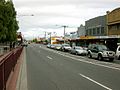
Clayton Road Shopping Precinct

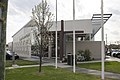
The exterior of the Australian Synchrotron facility

The Monash Homemaker centre in Clayton on Blackburn Road-Princes Hwy

St Peter's Primary School, Mary St.
Clayton Church of Christ on Burton Ave

Clayton Community Centre, Cooke St


References[]
- ^ Jump up to: a b c Australian Bureau of Statistics (27 June 2017). "Clayton (State Suburb)". 2016 Census QuickStats. Retrieved 1 December 2017.

- ^ Jump up to: a b Clayton Postcode Australia Post
- ^ Jump up to: a b Phoenix Auctions History, Post Office List, retrieved 1 April 2021
- ^ Nano centre to create innovation hub at Clayton- (Monash Memo, 16 April 2008) Archived 26 April 2008 at the Wayback Machine
- ^ http://www.jmss.vic.edu.au/
- ^ Full Point Footy, Clayton, archived from the original on 12 June 2010, retrieved 21 October 2008
- ^ "St. Andrew's Presbyterian Church, Clayton". standrewsclayton.org.au.
- ^ http://www.claytonchurch.org.au/
- ^ "All Saints Clayton". All Saints Clayton.
- ^ "Clayton Parish Mass Times :: St Peter's , Mannix College - Catholic Archdiocese of Melbourne (Australia) - Infobyte Software Solutions". cam.org.au.
- ^ "Clayton Christadelphians". Clayton Christadelphians.
- ^ "Islamic Association of Monash Mosque Inc. - Home". monashmosque.org.au.
External links[]
| Authority control: National libraries |
|---|
- Suburbs of Melbourne