CloudSat
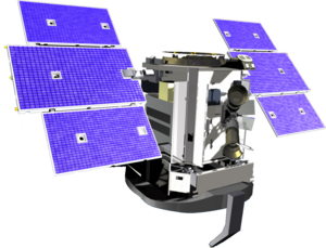 Artist's Concept of CloudSat | |
| Mission type | Atmospheric research |
|---|---|
| Operator | NASA |
| COSPAR ID | 2006-016B |
| SATCAT no. | 29107 |
| Website | CloudSat home page |
| Mission duration | Planned: 22 months Elapsed: 15 years, 9 months, 24 days |
| Spacecraft properties | |
| Bus | BCP-2000 |
| Manufacturer | Ball Aerospace |
| Launch mass | 700 kg (1,543 lb) |
| Dimensions | 2.54 × 2.03 × 2.29 m (8.3 × 6.7 × 7.5 ft) (H × L × W) |
| Start of mission | |
| Launch date | April 28, 2006, 10:02:16 UTC |
| Rocket | Delta II 7420-10C |
| Launch site | Vandenberg SLC-2W |
| Orbital parameters | |
| Reference system | Geocentric |
| Regime | LEO |
| Semi-major axis | 7,080.59 km (4,399.67 mi) |
| Eccentricity | 0.0000824 |
| Perigee altitude | 709 km (441 mi) |
| Apogee altitude | 710 km (440 mi) |
| Inclination | 98.23 degrees |
| Period | 98.83 minutes |
| RAAN | 330.82 degrees |
| Argument of perigee | 91.62 degrees |
| Mean anomaly | 14.57 degrees |
| Mean motion | 14.57 |
| Epoch | 25 January 2015, 03:10:38 UTC[1] |
| Revolution no. | 46,515 |
CloudSat is a NASA Earth observation satellite, which was launched on a Delta II rocket on April 28, 2006. It uses radar to measure the altitude and properties of clouds, adding to information on the relationship between clouds and climate in order to help resolve questions about global warming.[2]
It has been in daytime-only operations since 2011 due to battery malfunction, requiring sunlight to power the radar.
The mission was selected under NASA's in 1999. Ball Aerospace & Technologies Corp. in Boulder, Colorado, designed and built the spacecraft.
CloudSat's primary mission was scheduled to continue for 22 months in order to allow more than one seasonal cycle to be observed.
Instrument[]


The main instrument on CloudSat is the Cloud Profiling Radar (CPR), a 94-GHz nadir-looking radar that measures the power backscattered by clouds as a function of distance from the radar. The radar instrument was developed at NASA's Jet Propulsion Laboratory (JPL) in Pasadena, California, with hardware contributions from the Canadian Space Agency. The overall design of the CPR is simple, well understood, and has a strong heritage from the many cloud radars already in operation in ground-based and airborne applications. Most of the design parameters and subsystem configurations are nearly identical to those for the Airborne Cloud Radar, which has been flying on the NASA DC-8 aircraft since 1998.
The CPR capitalizes on existing radar expertise and experience at JPL. Other radars already flown successfully or being developed by JPL include the Seasat SAR, the Shuttle Imaging Radars (SIR-A, SIR-B, SIR-C), the Shuttle Radar Topography Mission (SRTM), Magellan Venus Radar Mapper, Cassini Radar (mapping Saturn's moon Titan), NSCAT, and SeaWinds.
Based on radar lifetime data, NASA expected the radar to operate for at least three years with a 99% probability.
CloudSat is managed by the Jet Propulsion Laboratory. Colorado State University provides scientific leadership and science data processing and distribution. The cost of this project is approximately $200 million.[3]
Impact on Radio Astronomy[]
Power levels of the CloudSat radar are such that the receiver electronics deployed on a typical radio telescope could be burned out if the telescope is pointing at the zenith during an overflight. Moreover, the typical receiver will probably saturate during an overflight (or near overflight) no matter where the radio telescope is pointed, and similarly-strong signal levels would be received if a telescope points at or near CloudSat whenever the satellite is above the horizon (which could be of order one hour per day at a typical location). The narrow-band, Doppler-shifted radar signal will probably be detectable in even fairly short integrations no matter where a radio telescope is pointed, whenever CloudSat is above the horizon.[4][5][6]
See also[]
- A-train (satellite constellation)
- Earth Observing System
- List of spaceflights (2006)
References[]
- ^ "CLOUDSAT Satellite details 2006-016A NORAD 29107". N2YO. 25 January 2015. Retrieved 25 January 2015.
- ^ Stephens, Graeme L.; Vane, Deborah G.; Boain, Ronald J.; Mace, Gerald G.; Sassen, Kenneth; Wang, Zhien; Illingworth, Anthony J.; O'connor, Ewan J.; Rossow, William B.; Durden, Stephen L.; Miller, Steven D.; Austin, Richard T.; Benedetti, Angela; Mitrescu, Cristian (2002). "THE CLOUDSAT MISSION AND THE A-TRAIN: A New Dimension of Space-Based Observations of Clouds and Precipitation". Bulletin of the American Meteorological Society. 83 (12): 1771–1790. doi:10.1175/BAMS-83-12-1771. ISSN 0003-0007.

- ^ "CloudSat Press Kit" (PDF). NASA/JPL.
- ^ "Radio Astronomy and CloudSat". Scientific Committee on Frequency Allocations for Radio Astronomy and Space Science. Retrieved 13 March 2020.
- ^ "CLOUDSAT - consequences for Radio Astronomy". Institut de Radioastronomie Millimétrique. Retrieved 13 March 2020.
- ^ Liszt, Harvey (2020-01-08). "Radio Astronomy in a New Era of Satellite Radiocommunication". AAS 235. p. 27m08s. Archived from the original on 2021-12-21. Retrieved 13 March 2020.
External links[]
- Weather satellites of the United States
- Spacecraft launched by Delta II rockets
- Spacecraft launched in 2006
- NASA satellites