Coldred
This article does not cite any sources. (May 2017) |
| Coldred | |
|---|---|
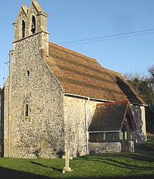 St Pancras, Coldred's Grade I listed Saxon church | |
 Coldred Location within Kent | |
| Civil parish |
|
| District |
|
| Shire county | |
| Region | |
| Country | England |
| Sovereign state | United Kingdom |
| Post town | Dover |
| Postcode district | CT15 |
| Police | Kent |
| Fire | Kent |
| Ambulance | South East Coast |
Coldred is a village in the Shepherdswell with Coldred civil parish in the Dover District of Kent, England.
The village name derives from the charcoal burners who lived here before the Norman conquest of England.[citation needed] The Oxford Dictionary of Place Names lists various spellings: Coeldred, Coelret and Colret.[citation needed]
Coldred, at nearly 400 feet (122 m) above sea level, is one of the highest places in East Kent.[citation needed]
The village contains 55 dwellings,[citation needed] and a church dedicated to St Pancras. Village children attend the primary school at Shepherdswell, less than 1 mile (2 km) to the northwest.
Coldred's population, which in 1994 was 110,[citation needed] is included in the civil parish of Sheperdswell with Coldred.
External links[]
 Media related to Coldred at Wikimedia Commons
Settlements in the Dover District of Kent | ||
|---|---|---|
 | Towns | |
| Villages and hamlets |
| |
| Civil parishes | ||
- Villages in Kent
- Dover District