Sholden
| Sholden | |
|---|---|
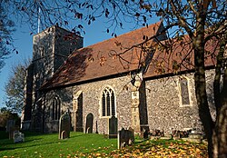 St Nicholas' Church, Sholden | |
 Sholden Location within Kent | |
| Population | 1,084 (2011)[1] |
| OS grid reference | TR355525 |
| District |
|
| Shire county | |
| Region | |
| Country | England |
| Sovereign state | United Kingdom |
| Post town | DEAL |
| Postcode district | CT14 |
| Dialling code | 01304 |
| Police | Kent |
| Fire | Kent |
| Ambulance | South East Coast |
| UK Parliament | |

Sholden is a small village adjacent to the seaside town of Deal, lying on the road towards Sandwich in Kent, South East England.
History[]
It has previously been known as 'Soldone' and 'Scholdon'.[2]
It has a Grade II* listed church, St Nicholas,[3] which is in the diocese of Canterbury, and deanery of Sandwich.[2] It also has a school, a cricket field and one public house, 'The Sportsman'.
It is the starting point of the Miner's Way Trail, a hiking trail linking up the coalfield parishes of East Kent.[4]
Governance[]
Sholden is part of the electoral ward of Middle Deal and Sholden. The population of this ward at the 2011 Census was 7,414.[5]
References[]
- ^ "Parish population 2011". Retrieved 4 October 2015.
- ^ a b Hasted, Edward (1800). "Parishes". The History and Topographical Survey of the County of Kent. Institute of Historical Research. 9: 605–611. Retrieved 12 January 2014.
- ^ British Listed Buildings retrieved 20 July 2013
- ^ "The History of the Coalfield Parishes". www.dover.gov.uk. Archived from the original on 13 January 2014. Retrieved 20 November 2013.
- ^ "Middle Deal and Sholden ward population 2011". Retrieved 4 October 2015.
External links[]
| Wikimedia Commons has media related to Sholden. |
Settlements in the Dover District of Kent | ||
|---|---|---|
 | Towns | |
| Villages and hamlets |
| |
| Civil parishes | ||
This Kent location article is a stub. You can help Wikipedia by . |
Categories:
- Villages in Kent
- Dover District
- Civil parishes in Kent
- Kent geography stubs