Barfrestone
| Barfrestone | |
|---|---|
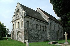 St Nicholas' Church, Barfrestone | |
 Barfrestone Location within Kent | |
| OS grid reference | TR261501 |
| District |
|
| Shire county | |
| Region | |
| Country | England |
| Sovereign state | United Kingdom |
| Post town | DOVER |
| Postcode district | CT15 |
| Dialling code | 01304 |
| Police | Kent |
| Fire | Kent |
| Ambulance | South East Coast |
| UK Parliament | |

Barfrestone is a village in East Kent, England, and between Shepherdswell, Eythorne and Nonington, and close to the pit villages of Elvington and Snowdown.
Alternative spellings are Barfreston and Barfreystone. The old pronunciation was "Barson" (before 1800) and the ancient name, "Barfriston".[1] Now known as "Bar-fre-ston", rather than "Bar-fre-stone".
At the time of the Domesday Book, when the name was written 'Berfrestone',[2] the manor was owned by Odo, Earl of Kent (as the Bishop of Bayeux). But after his trial (for fraud) in 1076, his assets were re-apportioned, including Barfrestone. The lands were then granted to Hugh de Port (an English feudal barony) for the defence of Dover castle. The lands passed through the hands of many other owners including Sir Thomas Browne (during the reign of Henry VI of England).[1]
Landmarks include the Grade I listed Norman church,[3][4] which contains significant carvings of human and animal figures on both the exterior and interior of the church, as well as a very early post-Roman example of the Greek key motif carved on the inside coving. Also of note is the church bell set in a yew tree adjacent to the church and "Little Ewell", a converted rectory which, until 2013, was the location of the centre (house, offices and workshops) of the L'Arche Kent Community which has since moved to Canterbury,[5] though a L'Arche house remains in the nearby village of Eythorne.
Another listed building in the village is Grade II listed Barfrestone Court,[6][7]
The village is on the Miner's Way Trail which links the coalfield parishes of East Kent.[8]
References[]
- ^ a b Hasted, Edward (1800). "Parishes". The History and Topographical Survey of the County of Kent. Institute of Historical Research. 10: 71–78. Retrieved 11 February 2014.
- ^ Mills, Anthony David (2003); A Dictionary of British Place Names, Oxford University Press, revised edition (2011), p. 41. ISBN 019960908X
- ^ "Church of St Nicholas, Eythorne". www.britishlistedbuildings.co.uk. Retrieved 4 December 2013.
- ^ Historic England. "Church of St Nicholas (Grade I) (1070306)". National Heritage List for England. Retrieved 17 September 2016.
- ^ "L'Arche". Retrieved 17 September 2016.
- ^ "Barfrestone Court, Eythorne". www.britishlistedbuildings.co.uk. Retrieved 4 December 2013.
- ^ Historic England. "Barfrestone Court (Grade II) (1122002)". National Heritage List for England. Retrieved 17 September 2016.
- ^ "The History of the Coalfield Parishes". www.dover.gov.uk. Archived from the original on 13 January 2014. Retrieved 20 November 2013.
External links[]
 Media related to Barfrestone at Wikimedia Commons
- Barfreston in the Domesday Book
Settlements in the Dover District of Kent | ||
|---|---|---|
 | Towns | |
| Villages and hamlets |
| |
| Civil parishes | ||
This Kent location article is a stub. You can help Wikipedia by . |
- Norman architecture in England
- Hamlets in Kent
- Kent geography stubs