Conghua District
Conghua
从化区 Tsungfa | |
|---|---|
District | |
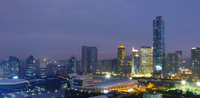
 Liuxi Riverfront Park in Jiekou Subdistrict | |
 | |
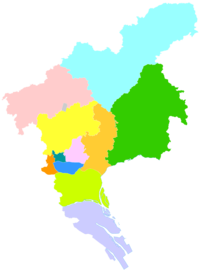 Conghua in Guangzhou | |
| Coordinates: 23°39′N 113°40′E / 23.650°N 113.667°ECoordinates: 23°39′N 113°40′E / 23.650°N 113.667°E | |
| Country | People's Republic of China |
| Province | Guangdong |
| Sub-provincial city | Guangzhou |
| Area | |
| • Total | 1,974.15 km2 (762.22 sq mi) |
| Population (2006) | |
| • Total | 543,377 |
| • Density | 280/km2 (710/sq mi) |
| Time zone | UTC+8 (China Standard) |
| Postal code | 510900 |
| Area code(s) | 020 |
| Website | www |

| Conghua | |||
|---|---|---|---|
| Simplified Chinese | 从化 | ||
| Traditional Chinese | 從化 | ||
| Guangdong Romanization | Cung4-fa3 | ||
| Hanyu Pinyin | Cónghuà | ||
| Postal | Tsungfa | ||
| Literal meaning | From Change | ||
| |||
Conghua District, alternately romanized as Tsungfa,[a] is one of 11 urban districts and the northernmost district of the prefecture-level city of Guangzhou, the capital of Guangdong Province, China. Conghua connects the Pearl River Delta with the mountainous area of northern Guangdong.[4] Within China, it is known for its hot springs[5] and lychees.[6] It covers an area of 1,974.15 km2 (762.22 sq mi), with a population of 543.377 in 2006. Its GDP was RMB10.369 billion (US$2,360 per person).[when?]
History[]
Under the Qing, the area was known as Conghua County. It was subsequently upgraded to county-level city status and then, on 12 February 2014, to an urban district of Guangzhou.[7]
Administrative divisions[]
| Name | Chinese (S) | Hanyu Pinyin | Canton Romanization | Population (2010)[8] | Area (km2) |
|---|---|---|---|---|---|
| 街口街道 | Jiēkǒu Jiēdào | gai1 heo2 gai1 dou6 | 96,846 | 21.84 | |
| 城郊街道 | Chéngjiāo Jiēdào | séng4 gao1 gai1 dou6 | 79,085 | 160.00 | |
| 江埔街道 | Jiāngbù Jiēdào | gong1 bou3 gai1 dou6 | 95,843 | 127.00 | |
| Wenquan town | 温泉镇 | Wēnquán Zhèn | wen1 qun4 zen3 | 55,194 | 210.90 |
| town | 良口镇 | Liángkǒu Zhèn | lêng4 heo2 zen3 | 32,829 | 530.60 |
| town | 吕田镇 | Lǚtián Zhèn | lêu5 tin4 zen3 | 23,430 | 393.00 |
| town | 太平镇 | Tàipíng Zhèn | tai3 ping4 zen3 | 94,369 | 210.32 |
| town | 鳌头镇 | Áotóu Zhèn | ngou4 teo4 zen3 | 111,308 | 410.00 |
Climate[]
| showClimate data for Conghua (1981−2010) |
|---|
See also[]
- Conghua city yueyuan animal breeding farm
- Guangzhou
- Wenquan, Guangdong
Notes[]
References[]
Citations[]
- ^ Baynes, T. S., ed. (1878), , Encyclopædia Britannica, 5 (9th ed.), New York: Charles Scribner's Sons
- ^ Chisholm, Hugh, ed. (1911). . Encyclopædia Britannica. XV (11th ed.). Cambridge University Press.
- ^ Gutzlaff (1838), p. 564.
- ^ "2011年统计用区划代码和城乡划分代码:从化市" (in Simplified Chinese). National Bureau of Statistics of the People's Republic of China. Retrieved 2012-11-17.
- ^ Conghua Hot Springs
- ^ Lychee
- ^ "黄埔萝岗合二为一 增城从化撤市改区". Nandu(南都网). Archived from the original on 22 February 2014. Retrieved 13 February 2014.
- ^ shi, Guo wu yuan ren kou pu cha ban gong; council, Guo jia tong ji ju ren kou he jiu ye tong ji si bian = Tabulation on the 2010 population census of the people's republic of China by township / compiled by Population census office under the state; population, Department of; statistics, employment statistics national bureau of (2012). Zhongguo 2010 nian ren kou pu cha fen xiang, zhen, jie dao zi liao (Di 1 ban. ed.). Beijing Shi: Zhongguo tong ji chu ban she. ISBN 978-7-5037-6660-2.
Bibliography[]
- Gutzlaff, Charles (1838), China Opened, or, A Display of the Topography, History, Customs, Manners, Arts, Manufactures, Commerce, Literature, Religion, Jurisprudence, Etc. of the Chinese Empire, Vol. II, London: Smith, Elder, & Co..
External links[]
- Official website of Guangdong Province
- Official website of Conghua Government
- Guangzhou International Website - English version
- Lychee Festival
| show Guangzhou |
|---|


| show Pearl River Delta Metropolitan Region (Guangdong-Hong Kong-Macau Greater Bay Area) |
|---|

Categories:
- County-level divisions of Guangdong
- Districts of Guangzhou