Connantray-Vaurefroy
From Wikipedia, the free encyclopedia
Commune in Grand Est, France
Connantray-Vaurefroy | |
|---|---|
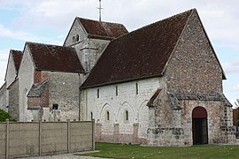 The church in Connantray | |
 Connantray-Vaurefroy  Connantray-Vaurefroy | |
Coordinates:  48°44′53″N 4°03′45″E / 48.7481°N 4.0625°E / 48.7481; 4.0625Coordinates: 48°44′53″N 4°03′45″E / 48.7481°N 4.0625°E / 48.7481; 4.0625 48°44′53″N 4°03′45″E / 48.7481°N 4.0625°E / 48.7481; 4.0625Coordinates: 48°44′53″N 4°03′45″E / 48.7481°N 4.0625°E / 48.7481; 4.0625 | |
| Country | France |
| Region | Grand Est |
| Department | Marne |
| Arrondissement | Épernay |
| Canton | Vertus-Plaine Champenoise |
| Intercommunality | Sud Marnais |
| Government | |
| • Mayor (2020–2026) | Thierry Mathellié |
| Area 1 | 28.83 km2 (11.13 sq mi) |
| Population (Jan. 2018)[1] | 150 |
| • Density | 5.2/km2 (13/sq mi) |
| Time zone | UTC+01:00 (CET) |
| • Summer (DST) | UTC+02:00 (CEST) |
| INSEE/Postal code | 51164 /51230 |
| 1 French Land Register data, which excludes lakes, ponds, glaciers > 1 km2 (0.386 sq mi or 247 acres) and river estuaries. | |

Connantray-Vaurefroy is a commune in the Marne department in north-eastern France.
See also[]
References[]
- ^ "Populations légales 2018". INSEE. 28 December 2020.
| Wikimedia Commons has media related to Connantray-Vaurefroy. |
show
| |
|---|---|
|
This Marne geographical article is a stub. You can help Wikipedia by . |
- v
- t
Retrieved from ""
Categories:
- Communes of Marne (department)
- Marne (department) geography stubs
Hidden categories:
- Articles with short description
- Short description is different from Wikidata
- Infobox mapframe without OSM relation ID on Wikidata
- Coordinates on Wikidata
- Pages using infobox settlement with image map1 but not image map
- Commons category link from Wikidata
- Articles with BNF identifiers
- All stub articles
- Pages using the Kartographer extension