Heutrégiville
Heutrégiville | |
|---|---|
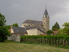 The church in Heutrégiville | |
show Location of Heutrégiville | |
 Heutrégiville | |
| Coordinates: 49°19′33″N 4°15′46″E / 49.3258°N 4.2628°ECoordinates: 49°19′33″N 4°15′46″E / 49.3258°N 4.2628°E | |
| Country | France |
| Region | Grand Est |
| Department | Marne |
| Arrondissement | Reims |
| Canton | Bourgogne |
| Intercommunality | CU Grand Reims |
| Government | |
| • Mayor (2020–2026) | Maryline Bailly |
| Area 1 | 11.80 km2 (4.56 sq mi) |
| Population (Jan. 2018)[1] | 461 |
| • Density | 39/km2 (100/sq mi) |
| Demonym(s) | Huldériquois |
| Time zone | UTC+01:00 (CET) |
| • Summer (DST) | UTC+02:00 (CEST) |
| INSEE/Postal code | 51293 /51110 |
| 1 French Land Register data, which excludes lakes, ponds, glaciers > 1 km2 (0.386 sq mi or 247 acres) and river estuaries. | |


Heutrégiville is a commune in the Marne department (region of Grand Est), in the arrondissement of Reims and in the canton of Bourgogne in north-eastern France.
Geography[]
The village lies on the right bank of the Suippe, which flows northwestward through the commune.
See also[]
References[]
- ^ "Populations légales 2018". INSEE. 28 December 2020.
| Wikimedia Commons has media related to Heutrégiville. |
This Marne geographical article is a stub. You can help Wikipedia by . |
Categories:
- Communes of Marne (department)
- Marne (department) geography stubs