Coopersville, Michigan
Coopersville, Michigan | |
|---|---|
 | |
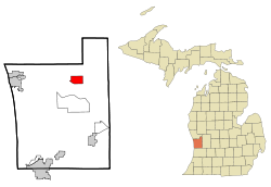 Location of Coopersville in Ottawa County, Michigan | |
| Coordinates: 43°3′50″N 85°56′10″W / 43.06389°N 85.93611°WCoordinates: 43°3′50″N 85°56′10″W / 43.06389°N 85.93611°W | |
| Country | United States |
| State | Michigan |
| County | Ottawa |
| incorporated | 1871 (as village) January 1, 1967 (as city) |
| Government | |
| • Mayor | Larry Crandle[1] |
| Area | |
| • Total | 4.81 sq mi (12.47 km2) |
| • Land | 4.81 sq mi (12.46 km2) |
| • Water | 0.00 sq mi (0.01 km2) 0% |
| Elevation | 636 ft (193.8 m) |
| Population | |
| • Total | 4,275 |
| • Estimate (2019)[6] | 4,387 |
| • Density | 912.06/sq mi (352.12/km2) |
| Time zone | UTC-5 (EST) |
| • Summer (DST) | UTC-4 (EDT) |
| ZIP code | 49404 |
| Area code(s) | 616 |
| FIPS code | 26-18020[4] |
| GNIS feature ID | 0623797[5] |
| Website | http://www.cityofcoopersville.com/ |

Coopersville is a city located in north central Ottawa County in the U.S. state of Michigan. The population was 4,275 at the 2010 census. It is primarily a farming community.
The city is located within Polkton Township, though it is administratively autonomous. It lies just north of Interstate 96 along the eastern township boundary, adjacent to Wright Township on the east. There are two exits on I-96, one at the southeast corner of the city and the other at the southwest corner.
Coopersville served as the primary filming location for the 2012 football film Touchback.
Geography[]
According to the United States Census Bureau, the city has a total area of 4.81 square miles (12.46 km2), all land.[7] Over 50% of the land within the city limits is committed to agriculture[8]
Demographics[]
| Historical population | |||
|---|---|---|---|
| Census | Pop. | %± | |
| 1880 | 645 | — | |
| 1890 | 790 | 22.5% | |
| 1900 | 660 | −16.5% | |
| 1910 | 814 | 23.3% | |
| 1920 | 914 | 12.3% | |
| 1930 | 1,004 | 9.8% | |
| 1940 | 1,083 | 7.9% | |
| 1950 | 1,371 | 26.6% | |
| 1960 | 1,584 | 15.5% | |
| 1970 | 2,129 | 34.4% | |
| 1980 | 2,889 | 35.7% | |
| 1990 | 3,421 | 18.4% | |
| 2000 | 3,910 | 14.3% | |
| 2010 | 4,275 | 9.3% | |
| 2019 (est.) | 4,387 | [6] | 2.6% |
| U.S. Decennial Census[9] | |||
2010 census[]
As of the census[3] of 2010, there were 4,275 people, 1,604 households, and 1,103 families living in the city. The population density was 888.8 inhabitants per square mile (343.2/km2). There were 1,742 housing units at an average density of 362.2 per square mile (139.8/km2). The racial makeup of the city was 95.5% White, 0.5% African American, 0.6% Native American, 0.7% Asian, 1.0% from other races, and 1.6% from two or more races. Hispanic or Latino of any race were 3.7% of the population.
There were 1,604 households, of which 39.8% had children under the age of 18 living with them, 51.2% were married couples living together, 13.3% had a female householder with no husband present, 4.2% had a male householder with no wife present, and 31.2% were non-families. 25.7% of all households were made up of individuals, and 12.2% had someone living alone who was 65 years of age or older. The average household size was 2.66 and the average family size was 3.23.
The median age in the city was 32.8 years. 29.3% of residents were under the age of 18; 9.8% were between the ages of 18 and 24; 27.8% were from 25 to 44; 22% were from 45 to 64; and 11.2% were 65 years of age or older. The gender makeup of the city was 48.3% male and 51.7% female.
2000 census[]
As of the census[4] of 2000, there were 3,910 people, 1,420 households, and 1,036 families living in the city. The population density was 812.5 per square mile (313.9/km2). There were 1,521 housing units at an average density of 316.1 per square mile (122.1/km2). The racial makeup of the city was 96.37% White, 0.20% African American, 0.64% Native American, 0.69% Asian, 1.28% from other races, and 0.82% from two or more races. Hispanic or Latino of any race were 2.71% of the population.

There were 1,420 households, out of which 39.6% had children under the age of 18 living with them, 57.9% were married couples living together, 11.7% had a female householder with no husband present, and 27.0% were non-families. 22.6% of all households were made up of individuals, and 8.9% had someone living alone who was 65 years of age or older. The average household size was 2.74 and the average family size was 3.21.
In the city, the population was spread out, with 30.2% under the age of 18, 10.9% from 18 to 24, 30.5% from 25 to 44, 18.3% from 45 to 64, and 10.1% who were 65 years of age or older. The median age was 31 years. For every 100 females, there were 93.9 males. For every 100 females age 18 and over, there were 86.2 males.
The median income for a household in the city was $48,875, and the median income for a family was $55,226. Males had a median income of $39,725 versus $22,464 for females. The per capita income for the city was $19,241. About 4.5% of families and 7.7% of the population were below the poverty line, including 5.4% of those under age 18 and 17.5% of those age 65 or over.
Education[]
Primary and secondary schools[]
- Coopersville Public Schools
- Coopersville High School
- Coopersville Middle School
- South Elementary
- East Elementary
- West Early Childhood Center
Transportation[]
Coopersville and Marne Railway
Major highways[]
Notable people[]
- Butch Miller, a NASCAR driver
- Del Shannon, 1960s rock singer and guitarist
- Tim Steele, an ARCA racer
References[]
- ^ "City Council Members". City of Coopersville. February 1, 2021. Retrieved February 1, 2021.
- ^ "2019 U.S. Gazetteer Files". United States Census Bureau. Retrieved July 25, 2020.
- ^ Jump up to: a b "U.S. Census website". United States Census Bureau. Retrieved 2012-11-25.
- ^ Jump up to: a b "U.S. Census website". United States Census Bureau. Retrieved 2008-01-31.
- ^ U.S. Geological Survey Geographic Names Information System: Coopersville, Michigan
- ^ Jump up to: a b "Population and Housing Unit Estimates". United States Census Bureau. May 24, 2020. Retrieved May 27, 2020.
- ^ "US Gazetteer files 2010". United States Census Bureau. Archived from the original on 2012-07-02. Retrieved 2012-11-25.
- ^ "The History Of Coopersville". City Of Coopersville. Retrieved April 26, 2021.
- ^ "Census of Population and Housing". Census.gov. Retrieved June 4, 2015.
External links[]
| show Municipalities and communities of Ottawa County, Michigan, United States |
|---|

| show Authority control |
|---|
- Cities in Ottawa County, Michigan
- 1871 establishments in Michigan
- Populated places established in 1871