Cooroy, Queensland
| Cooroy Sunshine Coast, Queensland | |||||||||||||||
|---|---|---|---|---|---|---|---|---|---|---|---|---|---|---|---|
 Myall Street, Cooroy | |||||||||||||||
 Cooroy | |||||||||||||||
| Coordinates | 26°25′00″S 152°54′43″E / 26.4166°S 152.9119°ECoordinates: 26°25′00″S 152°54′43″E / 26.4166°S 152.9119°E | ||||||||||||||
| Population | 3,791 (2016 census)[1] | ||||||||||||||
| • Density | 123.08/km2 (318.8/sq mi) | ||||||||||||||
| Established | 1885 | ||||||||||||||
| Postcode(s) | 4563 | ||||||||||||||
| Area | 30.8 km2 (11.9 sq mi) | ||||||||||||||
| Location | 22 km (14 mi) W of Noosa Heads | ||||||||||||||
| LGA(s) | Shire of Noosa | ||||||||||||||
| State electorate(s) | |||||||||||||||
| Federal Division(s) | Wide Bay | ||||||||||||||
| |||||||||||||||

Cooroy is a town and a locality in the Shire of Noosa, Queensland, Australia,[2][3] but between 2008 and 2013 it was in Sunshine Coast Region.
Cooroy has an attractive classic village center but has also been modernized in some respects. Cooroy's facilities include a hotel and a golf club. The Cooroy Motel is a 3-star accommodation directly opposite the train station. Noosa Botanical Garden is located at Lake MacDonald just outside the village. The Noosa District High School and Cooroy State Primary School are also located in Cooroy.
Geography[]
Cooroy is in the hinterland of the northern Sunshine Coast hinterland about 22 kilometres (14 mi) west of Noosa Heads. The Bruce Highway runs through the locality from south-east to north-west, bypassing the town. The Cooroy Noosa Road (State Route 6) runs north through the town from the Bruce Highway, then turns east.[4]
History[]
Cooroy's name came from Mount Cooroy, which was originally called Coorooey, from an Aboriginal word for possum, kurui.[5]
The area was explored by timber-cutters as early as 1863. Cooroy's main industry developed from timber, having two operating sawmills, into dairying and fruit growing. In 1915, a butter factory opened.[6]
Cooroy railway station was opened in 1891 and in the same year a post office opened.[6] A town survey was conducted in 1907.
Cooroy State School opened in 1909. Cooroy West State School opened in 1911 but closed in 1962.[7]
In February 1910 it was proposed to build a Methodist Church at Cooroy.[8] In July 1911 a call for tenders to erect the church was issued.[9] The stump-capping ceremony was held on Thursday 7 September 1911.[10] The church was officially opened on Wednesday 31 January 1912 by Harry Walker,[11] followed by a social evening to celebrate the following day.[12] On 19 February 1949 the current church building opened and the 1911 church building became the church hall, having been relocated to the back of the site.[13] With the amalgamation of the Methodist Church into the Uniting Church in Australia in 1977, it became the Cooroy Uniting Church.[14]
The Anglican Church of the Holy Nativity was dedicated on 21 March 1914 by Archdeacon Henry Le Fanu.[15] That church was destroyed by a cyclone on 19 February 1954.[16] On Sunday 7 November 1954 Archbishop Reginald Halse dedicated the new church.[17][18]
On 23 January 1961 a secondary department was added to Cooroy State School until the Cooroy State High School was opened as a separate school on 23 January 1963. In 1967 it became Noosa District State High School. In 2007, it was Cooroora Secondary College at Pomona which was merged into Noosa District State High School, with the Pomona campus being used for the younger students and Cooroy campus being used for the older students.[7]
Noosa Christian College opened on 28 January 2003 as a primary school with 37 students. In 2007 it expanded to offer secondary classes.[7][19]
The town was bisected by the Bruce Highway until a bypass was built in 1994.[20]
The Cooroy Library opened in 2010.[21]
To this day, Cooroy bills itself as the "Heart of the Hinterland", for its vibrant communal creativity and tranquil country hospitality.
Heritage listings[]
Cooroy has a number of heritage-listed sites, including:
- Lower Mill Road: Cooroy Lower Mill Site Kiln[22]
- 33 Maple Street: Cooroy Post Office[23]
- 14 Myall Street: Cooroy railway station[24]
Amenities[]

Cooroy has one hotel, a library, a police station, a golf club, a bowls club, the RSL club and sub branch, a selection of cafes and restaurants, unique retail outlets and a range of accommodation options. Noosa Botanical Gardens is situated on Lake MacDonald just outside the town and several of the Noosa Trails are accessible in Cooroy. An overnight RV park has opened at Johnson Park.
The Shire of Noosa operates a library at 9 Maple Street.[25]
In 1991 Noosa Shire Council purchased former Butter Factory buildings for use as a community centre which is now run by Cooroy Future Group as an arts centre.
Cooroy Pomona Uniting Church is at 51 Maple Street (26°25′13″S 152°54′33″E / 26.4204°S 152.9092°E).[26][27][14]
Community service groups[]
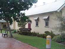
The Cooroy branch of the Queensland Country Women's Association meets at the Cooroy Memorial Hall & School of Arts at 23 Maple Street.[28]
Cooroy-Pomona RSL Sub-Branch is at 25 Maple Street.[29]
Other groups include:[citation needed]
- Cooroy Memorial Hall Association Inc. (based in Cooroy)
- Cooroy Future Group Inc (based in Cooroy)
- Cooroy Area Residents Association Inc.
- Cooroy Chamber of Commerce
- Rotary Club of Cooroy
- Cooroy Scout Group
Economy[]
This section needs expansion. You can help by . (August 2021) |
Education[]
Cooroy State School is a primary (P-6) school for boys and girls operated by the Queensland Government at 59 Elm Street. In 2016, the school had an enrolment of 545 students with 40 teachers (34 full-time equivalent) and 24 non-teaching staff (15 full-time equivalent).[30]
Noosa District State High School is a secondary (7-12) school for boys and girls operated by the Queensland Government over two campuses, one at 120 Summit Road, Pomona, for Years 7-8 and the other at Tulip Street in Cooroy for Years 9-12. In 2016, the school had a total enrolment of 1335 students with 111 teachers (106 full-time equivalent) and 48 non-teaching staff (40 full-time equivalent).[31]
Noosa Christian College is a primary and secondary school (P-12) for boys and girls operated by Adventist Schools Australia at 20 Cooroy Belli Creek Road. In 2016, the school had an enrolment of 243 students with 21 teachers (19.1 full-time equivalent) and 14 non-teaching staff.[32]
Cooroy Community Kindergarten (CCK) is at 13-15 Maple Street.[33]
Notable residents[]
- Major General John Cantwell, AO, DSC (Retd.) – former Deputy Chief of Army
- Marayke Jonkers – Bronze and Silver medal Paralympic swimmer
Transport[]
Cooroy railway station is serviced by two daily Queensland Rail City network services in each direction.[34]
See also[]
References[]
- ^ Australian Bureau of Statistics (27 June 2017). "Cooroy (SSC)". 2016 Census QuickStats. Retrieved 17 October 2017.

- ^ "Cooroy – town in Shire of Noosa (entry 8317)". Queensland Place Names. Queensland Government. Retrieved 17 October 2017.
- ^ "Cooroy – locality in Shire of Noosa (entry 48584)". Queensland Place Names. Queensland Government. Retrieved 17 October 2017.
- ^ Google (13 August 2019). "Cooroy, Queensland" (Map). Google Maps. Google. Retrieved 13 August 2019.
- ^ South East Queensland – Place Names Archived 22 June 2005 at the Wayback Machine 16 December 2006
- ^ Jump up to: a b Environmental Protection Agency (Queensland) (2000). Heritage Trails of the Great South East. State of Queensland. p. 143. ISBN 0-7345-1008-X.
- ^ Jump up to: a b c Queensland Family History Society (2010), Queensland schools past and present (Version 1.01 ed.), Queensland Family History Society, ISBN 978-1-921171-26-0
- ^ "BELOW THE RANGE". The Brisbane Courier (16, 265). Queensland, Australia. 28 February 1910. p. 2. Archived from the original on 12 September 2021. Retrieved 12 September 2021 – via National Library of Australia.
- ^ "Advertising". Gympie Times And Mary River Mining Gazette. XLIV (5706). Queensland, Australia. 29 July 1911. p. 2. Archived from the original on 12 September 2021. Retrieved 12 September 2021 – via National Library of Australia.
- ^ "Advertising". Gympie Times And Mary River Mining Gazette. XLIV (5706). Queensland, Australia. 29 July 1911. p. 2. Archived from the original on 12 September 2021. Retrieved 12 September 2021 – via National Library of Australia.
- ^ "COOROY". Gympie Times And Mary River Mining Gazette. XLV (5783). Queensland, Australia. 27 January 1912. p. 4. Archived from the original on 12 September 2021. Retrieved 12 September 2021 – via National Library of Australia.
- ^ "COOROY". Gympie Times And Mary River Mining Gazette. XLV (5789). Queensland, Australia. 10 February 1912. p. 4. Archived from the original on 12 September 2021. Retrieved 12 September 2021 – via National Library of Australia.
- ^ "COOROY". Nambour Chronicle And North Coast Advertiser (2320). Queensland, Australia. 3 December 1948. p. 1. Archived from the original on 12 September 2021. Retrieved 12 September 2021 – via National Library of Australia.
- ^ Jump up to: a b "Cooroy Uniting Church". Churches Australia. Archived from the original on 12 September 2021. Retrieved 12 September 2021.
- ^ "COOROY". Chronicle And North Coast Advertiser. XI (499). Queensland, Australia. 27 March 1914. p. 5. Archived from the original on 22 December 2020. Retrieved 7 July 2020 – via National Library of Australia.
- ^ "NORTH COAST SUFFERS TOO". Truth (2813). Brisbane. 21 February 1954. p. 4. Archived from the original on 22 December 2020. Retrieved 7 July 2020 – via National Library of Australia.
- ^ "He planned own church". The Courier-Mail. Brisbane. 5 November 1954. p. 6. Retrieved 7 July 2020 – via National Library of Australia.
- ^ "The Church of the Holy Nativity | Churches Australia". churchesaustralia.org. Archived from the original on 7 July 2020. Retrieved 7 July 2020.
- ^ "Facts & Figures". Noosa Christian College. Archived from the original on 17 October 2017. Retrieved 17 October 2017.
- ^ Queensland Transport Annual Report 1993–1994
- ^ "Public Libraries Statistical Bulletin 2016–17" (PDF). Public Libraries Connect. State Library of Queensland. November 2017. p. 15. Archived (PDF) from the original on 30 January 2018. Retrieved 30 January 2018.
- ^ "Cooroy Lower Mill Site Kiln (entry 602688)". Queensland Heritage Register. Queensland Heritage Council. Retrieved 14 July 2013.
- ^ "Cooroy Post Office (Place ID 106202)". Australian Heritage Database. Department of the Environment. Retrieved 1 October 2018.
- ^ "Cooroy Railway Station (entry 602381)". Queensland Heritage Register. Queensland Heritage Council. Retrieved 14 July 2013.
- ^ "Noosa Libraries". Noosa Council. Archived from the original on 7 June 2017. Retrieved 19 January 2018.
- ^ "Find a Church". Uniting Church in Australia, Queensland Synod. Archived from the original on 24 October 2020. Retrieved 22 November 2020.
- ^ "Cooroy Pomona". Mary Burnett Presbytery. Archived from the original on 22 May 2021. Retrieved 12 September 2021.
- ^ "Find Your Closest Branch". Queensland Country Women's Association. Archived from the original on 22 June 2020. Retrieved 22 June 2020.
- ^ "Home". Cooroy RSL. Archived from the original on 16 November 2020. Retrieved 22 December 2020.
- ^ "Annual Report 2016" (PDF). Cooroy State School. Archived (PDF) from the original on 17 October 2017. Retrieved 17 October 2017.
- ^ "Annual Report 2016" (PDF). Noosa District State High School. Archived from the original (PDF) on 17 October 2017. Retrieved 17 October 2017.
- ^ "2016 Annual Report". Noosa Christian College. Archived from the original on 17 October 2017. Retrieved 17 October 2017.
- ^ "Cooroy Community Kindergarten". Lady Gowrie. Archived from the original on 18 October 2017. Retrieved 17 October 2017.
- ^ "Sunshine Coast Line timetable". TransLink. 2 March 2020.
External links[]
- Cooroy Website
- Cooroy Area Residents Association Inc
- Cooroy Rotary Club
- Christmas in Cooroy
- Cooroy Fusion Festival
- Cooroy Chamber of Commerce Inc
- University of Queensland: Queensland Places: Cooroy
- "Walk Cooroy" (PDF) (brochure). Sunshine Coast Regional Council. Archived (PDF) from the original on 17 October 2017.
- Town map of Cooroy, 1978
- Towns in Queensland
- Cooroy, Queensland
- Suburbs of Noosa Shire, Queensland
- Populated places established in 1885
- Localities in Queensland