Cow Creek, South Dakota
Cow Creek, South Dakota | |
|---|---|
 Cow Creek, South Dakota | |
| Coordinates: 44°33′14″N 100°28′31″W / 44.55389°N 100.47528°WCoordinates: 44°33′14″N 100°28′31″W / 44.55389°N 100.47528°W | |
| Country | United States |
| State | South Dakota |
| County | Sully |
| Area | |
| • Total | 1.831 sq mi (4.74 km2) |
| • Land | 1.831 sq mi (4.74 km2) |
| • Water | 0 sq mi (0 km2) |
| Elevation | 1,650 ft (500 m) |
| Population | |
| • Total | 30 |
| • Density | 16/sq mi (6.3/km2) |
| Time zone | UTC-6 (Central (CST)) |
| • Summer (DST) | UTC-5 (CDT) |
| Area code(s) | 605 |
| GNIS feature ID | 2584551[2] |


Cow Creek is an unincorporated community and census-designated place in Sully County, South Dakota, United States. Its population was 30 as of the 2010 census.[1] The community is located on the eastern shore of Lake Oahe.
Geography[]
According to the U.S. Census Bureau, the community has an area of 1.831 square miles (4.74 km2), all land.[1]
References[]
- ^ a b c d "2010 Census Gazetteer Files - Places: South Dakota". U.S. Census Bureau. Retrieved January 28, 2017.
- ^ "Cow Creek Census Designated Place". Geographic Names Information System. United States Geological Survey.
Municipalities and communities of Sully County, South Dakota, United States | ||
|---|---|---|
| City | 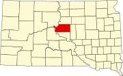 | |
| Town | ||
| CDP | ||
| ||
This South Dakota state location article is a stub. You can help Wikipedia by . |
Categories:
- Unincorporated communities in Sully County, South Dakota
- Unincorporated communities in South Dakota
- Census-designated places in Sully County, South Dakota
- Census-designated places in South Dakota
- South Dakota geography stubs