Onida, South Dakota
Onida, South Dakota | |
|---|---|
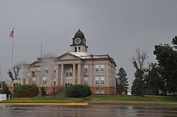 Sully County Courthouse, July 2013 | |
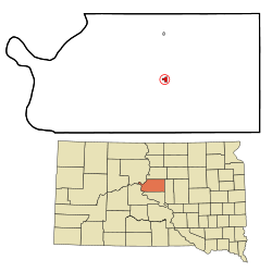 Location in Sully County and the state of South Dakota | |
| Coordinates: 44°42′21″N 100°4′1″W / 44.70583°N 100.06694°WCoordinates: 44°42′21″N 100°4′1″W / 44.70583°N 100.06694°W | |
| Country | United States |
| State | South Dakota |
| County | Sully |
| Founded | 1880 |
| Incorporated | 1883[1] |
| Area | |
| • Total | 0.67 sq mi (1.74 km2) |
| • Land | 0.67 sq mi (1.74 km2) |
| • Water | 0.00 sq mi (0.00 km2) |
| Elevation | 1,873 ft (571 m) |
| Population | |
| • Total | 658 |
| • Estimate (2019)[3] | 634 |
| • Density | 943.45/sq mi (364.17/km2) |
| Time zone | UTC-6 (Central (CST)) |
| • Summer (DST) | UTC-5 (CDT) |
| ZIP code | 57564 |
| Area code(s) | 605 |
| FIPS code | 46-47180[5] |
| GNIS feature ID | 1256897[6] |
| Website | www |

Onida is a city in and the county seat of Sully County, South Dakota, United States. The population was 658 as of the 2010 census.[7]
History[]
Onida was founded in 1880 by settlers from Oneida, New York.[8] It received its city rights in 1883.[9]
Geography[]
Onida is located at 44°42′21″N 100°4′1″W / 44.70583°N 100.06694°W (44.705939, -100.066851).[10]
According to the United States Census Bureau, the city has a total area of 0.64 square miles (1.66 km2), all land.[11]
Onida has been assigned the ZIP code 57564 and the FIPS place code 47180.
Demographics[]
| Historical population | |||
|---|---|---|---|
| Census | Pop. | %± | |
| 1910 | 319 | — | |
| 1920 | 455 | 42.6% | |
| 1930 | 636 | 39.8% | |
| 1940 | 597 | −6.1% | |
| 1950 | 822 | 37.7% | |
| 1960 | 843 | 2.6% | |
| 1970 | 785 | −6.9% | |
| 1980 | 851 | 8.4% | |
| 1990 | 761 | −10.6% | |
| 2000 | 740 | −2.8% | |
| 2010 | 658 | −11.1% | |
| 2019 (est.) | 634 | [3] | −3.6% |
| U.S. Decennial Census[12] | |||
2010 census[]
As of the census[4] of 2010, there were 658 people, 280 households, and 186 families residing in the city. The population density was 1,028.1 inhabitants per square mile (397.0/km2). There were 331 housing units at an average density of 517.2 per square mile (199.7/km2). The racial makeup of the city was 95.4% White, 1.8% Native American, and 2.7% from two or more races. Hispanic or Latino people of any race were 0.8% of the population.
There were 280 households, of which 33.9% had children under the age of 18 living with them, 57.1% were married couples living together, 6.1% had a female householder with no husband present, 3.2% had a male householder with no wife present, and 33.6% were non-families. 30.4% of all households were made up of individuals, and 9.6% had someone living alone who was 65 years of age or older. The average household size was 2.35 and the average family size was 2.91.
The median age in the city was 42.7 years. 25.8% of residents were under the age of 18; 4.1% were between the ages of 18 and 24; 23.2% were from 25 to 44; 29.9% were from 45 to 64; and 17% were 65 years of age or older. The gender makeup of the city was 53.5% male and 46.5% female.
2000 census[]
As of the census[5] of 2000, there were 740 people, 299 households, and 200 families residing in the city. The population density was 1,165.9 people per square mile (453.5/km2). There were 329 housing units at an average density of 518.3 per square mile (201.6/km2). The racial makeup of the city was 98.51% White, 0.54% Native American, and 0.95% from two or more races. Hispanic or Latino people of any race were 0.41% of the population.
There were 299 households, out of which 35.5% had children under the age of 18 living with them, 59.5% were married couples living together, 4.7% had a female householder with no husband present, and 32.8% were non-families. 28.8% of all households were made up of individuals, and 12.4% had someone living alone who was 65 years of age or older. The average household size was 2.47 and the average family size was 3.10.
In the city, the population was spread out, with 28.4% under the age of 18, 6.1% from 18 to 24, 29.2% from 25 to 44, 22.6% from 45 to 64, and 13.8% who were 65 years of age or older. The median age was 37 years. For every 100 females, there were 101.1 males. For every 100 females age 18 and over, there were 101.5 males.
The median income for a household in the city was $35,750, and the median income for a family was $44,583. Males had a median income of $27,692 versus $22,266 for females. The per capita income for the city was $19,340. About 5.0% of families and 5.2% of the population were below the poverty line, including 4.4% of those under age 18 and 11.8% of those age 65 or over.
Notable people[]
- Curt Byrum, professional golfer; has played on the PGA Tour and the Nationwide Tour; brother of Tom Byrum
- Tom Byrum, professional golfer; has played on the PGA Tour; brother of Curt Byrum
- Hubert W. Woodruff, Illinois state senator and lawyer; he was born in Onida.
See also[]
References[]
- ^ "SD Towns" (PDF). South Dakota State Historical Society. Retrieved 2010-02-14.
- ^ "2019 U.S. Gazetteer Files". United States Census Bureau. Retrieved July 30, 2020.
- ^ Jump up to: a b "Population and Housing Unit Estimates". United States Census Bureau. May 24, 2020. Retrieved May 27, 2020.
- ^ Jump up to: a b "U.S. Census website". United States Census Bureau. Retrieved 2012-06-21.
- ^ Jump up to: a b "U.S. Census website". United States Census Bureau. Retrieved 2008-01-31.
- ^ U.S. Geological Survey Geographic Names Information System: Onida
- ^ "Find a County". National Association of Counties. Retrieved 2011-06-07.
- ^ Jensen, Jamie (1 December 2012). Road Trip USA: Cross-Country Adventures on America's Two-Lane Highways. Avalon Travel Publishing. p. 194. ISBN 978-1-61238-315-6.
- ^ Hellmann, Paul T. (May 13, 2013). Historical Gazetteer of the United States. Routledge. p. 994. Retrieved 30 November 2013.
- ^ "US Gazetteer files: 2010, 2000, and 1990". United States Census Bureau. 2011-02-12. Retrieved 2011-04-23.
- ^ "US Gazetteer files 2010". United States Census Bureau. Archived from the original on 2012-01-25. Retrieved 2012-06-21.
- ^ United States Census Bureau. "Census of Population and Housing". Retrieved June 13, 2016.
External links[]
| Wikimedia Commons has media related to Onida, South Dakota. |
| show Municipalities and communities of Sully County, South Dakota, United States |
|---|
| show Authority control |
|---|
- Cities in South Dakota
- Cities in Sully County, South Dakota
- County seats in South Dakota
- Populated places established in 1880
- 1880 establishments in Dakota Territory