Crafton, Pennsylvania
Crafton, Pennsylvania | |
|---|---|
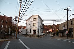 Intersection of East Crafton, Noble and Dinsmore Avenues in Crafton, PA. | |
 Location in Allegheny County and the U.S. state of Pennsylvania. | |
 Location of Pennsylvania in the United States | |
| Coordinates: 40°26′1.93″N 80°4′5.33″W / 40.4338694°N 80.0681472°WCoordinates: 40°26′1.93″N 80°4′5.33″W / 40.4338694°N 80.0681472°W | |
| Country | United States |
| State | Pennsylvania |
| County | Allegheny |
| Government | |
| • Type | Borough |
| • Body | Borough Council |
| • Mayor | James Bloom |
| • Council President | Phillip Levasseur |
| Area | |
| • Total | 1.14 sq mi (2.96 km2) |
| • Land | 1.14 sq mi (2.96 km2) |
| • Water | 0.00 sq mi (0.00 km2) |
| Population (2010) | |
| • Total | 5,951 |
| • Estimate (2019)[2] | 5,770 |
| • Density | 5,048.12/sq mi (1,948.26/km2) |
| Time zone | UTC−5 (EST) |
| • Summer (DST) | UTC−4 (EDT) |
| ZIP Code | 15205 |
| Area code(s) | 412 |
| FIPS code | 42-16848 |
| Website | Crafton Borough |
Crafton is a borough in Allegheny County, Pennsylvania, United States, west of downtown Pittsburgh. The population grew from 1,927 in 1900 to 4,583 in 1910 and to 7,163 in 1940. The population was 5,951 at the 2010 census.[3]
History[]
Crafton is named after James S. Craft, a frontier attorney who was granted land near the "forks of the Ohio" in present-day Oakland.[4] The sale of this land part financed purchases of land in the Chartiers valley. Charles Craft, son of James, divided the land into lots on the death of his father and submitted it to the Allegheny County Courthouse as Crafton. Following a period of building, the borough was incorporated on January 8, 1892, with Charles as the first burgess.[5]
Crafton was linked to downtown Pittsburgh by trolley in 1896. The service ended when the Fort Pitt Bridge was built without trolley tracks.
Geography[]
Crafton is located at 40°26′2″N 80°4′5″W / 40.43389°N 80.06806°W (40.433869, -80.068146).[6]
According to the United States Census Bureau, the borough has a total area of 1.1 square miles (2.8 km2), all of it land.
Surrounding and adjacent neighborhoods[]
Crafton has six land borders, including Ingram to the north and the Pittsburgh neighborhoods of Crafton Heights to the northeast, Westwood to the east, Oakwood and East Carnegie to the south, and Fairywood to the northwest. Across Chartiers Creek, Crafton runs adjacent with Thornburg to the west and Rosslyn Farms to the southwest.
Demographics[]
| Historical population | |||
|---|---|---|---|
| Census | Pop. | %± | |
| 1900 | 1,927 | — | |
| 1910 | 4,583 | 137.8% | |
| 1920 | 5,954 | 29.9% | |
| 1930 | 7,004 | 17.6% | |
| 1940 | 7,163 | 2.3% | |
| 1950 | 8,066 | 12.6% | |
| 1960 | 8,418 | 4.4% | |
| 1970 | 8,233 | −2.2% | |
| 1980 | 7,623 | −7.4% | |
| 1990 | 7,188 | −5.7% | |
| 2000 | 6,706 | −6.7% | |
| 2010 | 5,951 | −11.3% | |
| 2019 (est.) | 5,770 | [2] | −3.0% |
| Sources:[7][8][9][10][11][12] | |||
As of the census[11] of 2000, there were 6,706 people, 3,079 households, and 1,613 families residing in the borough. The population density was 5,916.0 people per square mile (2,291.3/km2). There were 3,344 housing units at an average density of 2,950.1 per square mile (1,142.6/km2). The racial makeup of the borough was 95.50% White, 2.74% African American, 0.10% Native American, 0.60% Asian, 0.07% Pacific Islander, 0.15% from other races, and 0.84% from two or more races. Hispanic or Latino of any race were 0.57% of the population.
There were 3,080 households, out of which 24.9% had children under the age of 18 living with them, 38.2% were married couples living together, 10.6% had a female householder with no husband present, and 47.6% were non-families. 40.2% of all households were made up of individuals, and 14.3% had someone living alone who was 65 years of age or older. The average household size was 2.17 and the average family size was 3.01.
In the borough the population was spread out, with 21.6% under the age of 18, 8.6% from 18 to 24, 32.5% from 25 to 44, 22.6% from 45 to 64, and 14.8% who were 65 years of age or older. The median age was 38 years. For every 100 females, there were 90.1 males. For every 100 females age 18 and over, there were 86.9 males.
The median income for a household in the borough was $38,323, and the median income for a family was $52,386. Males had a median income of $38,292 versus $24,497 for females. The per capita income for the borough was $21,441. About 3.4% of families and 6.9% of the population were below the poverty line, including 6.5% of those under age 18 and 6.2% of those age 65 or over.
Government and politics[]
| Year | Republican | Democratic | Third Parties |
|---|---|---|---|
| 2016 | 37% 1,175 | 57% 1,810 | 5% 170 |
| 2012 | 41% 1,191 | 57% 1,677 | 2% 53 |
Notable people[]
Bill Cowher, Former Pittsburgh Steelers head coach and current NFL analyst. Cowher is a native of Crafton and attended Carlynton High School.
Alpha L. Bowser (August 21, 1910 – July 13, 2003), United States Marine Corps lieutenant general. He was a combat veteran of World War II and the Korean War — decorated for his actions during the Battle of Iwo Jima and in the Battle of Chosin Reservoir.
Paul Shannon, Legendary Pittsburgh radio and television host.
Gallery[]
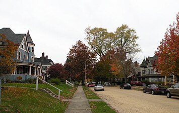
Creighton Avenue, platted in 1895
, built in 1906, located at 50 West Crafton Avenue

, built in 1908, located at 33 Alice Street

The Campbell Building, circa 1910, located at 3 Crafton Square

, built in 1913, located at 1874 Crafton Boulevard

The George Leber House, built in 1938, located at 132 East Crafton Avenue

, located at Noble and Bradford avenues


References[]
- ^ "2019 U.S. Gazetteer Files". United States Census Bureau. Retrieved July 28, 2020.
- ^ Jump up to: a b "Population and Housing Unit Estimates". United States Census Bureau. May 24, 2020. Retrieved May 27, 2020.
- ^ "Race, Hispanic or Latino, Age, and Housing Occupancy: 2010 Census Redistricting Data (Public Law 94-171) Summary File (QT-PL), Crafton borough, Pennsylvania". United States Census Bureau. Retrieved September 19, 2011.
- ^ "Crafton Historical Society". Retrieved July 8, 2010.
- ^ Martin, Betsy (1992). The Story of Crafton: 1740–1992. Crafton Historical Society. pp. 43–44.
- ^ "US Gazetteer files: 2010, 2000, and 1990". United States Census Bureau. 2011-02-12. Retrieved 2011-04-23.
- ^ "Population-Pennsylvania" (PDF). U.S. Census 1910. U.S. Census Bureau. Retrieved 22 November 2013.
- ^ "Number and Distribution of Inhabitants:Pennsylvania-Tennessee" (PDF). Fifteenth Census. U.S. Census Bureau.
- ^ "Number of Inhabitants: Pennsylvania" (PDF). 18th Census of the United States. U.S. Census Bureau. Retrieved 22 November 2013.
- ^ "Pennsylvania: Population and Housing Unit Counts" (PDF). U.S. Census Bureau. Retrieved 22 November 2013.
- ^ Jump up to: a b "U.S. Census website". United States Census Bureau. Retrieved 2008-01-31.
- ^ "Annual Estimates of the Resident Population". U.S. Census Bureau. Archived from the original on 2 June 2013. Retrieved 22 November 2013.
- ^ EL. "2012 Allegheny County election". Pittsburgh Tribune-Review. Retrieved 15 October 2017.
- ^ EL. "2016 Pennsylvania general election results". Pittsburgh Post-Gazette. Retrieved 15 October 2017.
External links[]
| Wikimedia Commons has media related to Crafton, Pennsylvania. |
| show Greater Pittsburgh Region |
|---|

| show Municipalities and communities of Allegheny County, Pennsylvania, United States |
|---|

| show Authority control |
|---|
- Populated places established in 1872
- Pittsburgh metropolitan area
- Boroughs in Allegheny County, Pennsylvania
- 1872 establishments in Pennsylvania