Crewe and Nantwich Circular Walk

Waymarker
| Crewe and Nantwich Circular Walk | |
|---|---|
 At the Dorfold Estate | |
| Length | 47 km (29 mi) |
| Location | Cheshire, England |
| Use | Hiking |
| Hiking details | |
| Season | All year |
The Crewe and Nantwich Circular Walk is a 29-mile (47 km) long-distance walkers' path in the Cheshire East area of Cheshire, England. As the name suggests, the walk forms a circuit around the towns of Crewe and Nantwich. It is one of two circular walks in the county of Cheshire, the other being the .
The walk is waymarked with a circle with symbols of a leaf, cartwheel and crossed swords. Although mainly on level terrain, the many stiles make the walk unsuitable for people with mobility problems.
Route and sights of interest[]

Shrewbridge Lake, Nantwich

Brickyard Bridge on the Shropshire Union Canal

Haslington Hall
The walk is divided into three sections, with sights of interest as follows:
Weston to Acton[]
10 miles (16 km)
- Weston
- Hough Common
- Wybunbury
- Mill Bank Farm, with site of medieval watermill
- Old Hall Austerson, with 16th-century barn
- Shrewbridge Lake, saltwater lake on the outskirts of Nantwich
- Dorfold Hall, Jacobean manor house
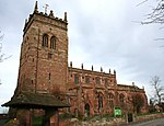
- St Mary's Church, Acton, with tower dating from the 13th century. The churchyard has a 17th-century sundial and almhouses dating from 1613.
- Acton village has several buildings dating from the 17th and 18th centuries
Acton to Coppenhall[]
10.5 miles (17 km)
- Henhull, site of Roman road
- Reaseheath College
- Middlewich branch of the Shropshire Union Canal, with Brickyard Bridge, named after an adjacent brickworks
- Moat House Farm, with remains of unusual old moat structure
Coppenhall to Weston[]
8.5 miles (14 km)
- Coppenhall Moss, site of former peat bog, now drained
- Sandbach Flashes, series of salt water pools, good for bird-watching
- Winterley, former millpond, now home to mute swans
- Haslington Hall, Tudor house
- Valley Brook, surrounded by old woodland
See also[]
Reference[]
Cheshire Portal | |
| Unitary authorities | |
| Major settlements |
|
| Rivers | |
| Topics | |
Categories:
- Long-distance footpaths in England
- Footpaths in Cheshire