Frodsham
| Frodsham | |
|---|---|
 Frodsham from Overton/Frodsham Hill | |
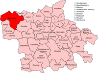
 Frodsham Location within Cheshire | |
| Population | 9,077 [1] |
| OS grid reference | SJ520775 |
| Civil parish |
|
| Unitary authority |
|
| Ceremonial county |
|
| Region |
|
| Country | England |
| Sovereign state | United Kingdom |
| Post town | FRODSHAM |
| Postcode district | WA6 |
| Dialling code | 01928 |
| Police | Cheshire |
| Fire | Cheshire |
| Ambulance | North West |
| UK Parliament | |

Frodsham /ˌfrɒdʃəm/ (![]() listen) is a market town, civil parish and electoral ward in the unitary authority of Cheshire West and Chester and the ceremonial county of Cheshire, England. Its population was 8,982 in 2001, increasing to 9,077 at the 2011 Census.[1][2] It is approximately 3 miles (5 km) south of Runcorn, 16 miles (26 km) south of Liverpool, and 28 miles (45 km) southwest of Manchester. The River Weaver runs to its northeast and on the west it overlooks the estuary of the River Mersey. The A56 road and the Chester–Manchester railway line pass through the town, and the M56 motorway passes to the northwest.
listen) is a market town, civil parish and electoral ward in the unitary authority of Cheshire West and Chester and the ceremonial county of Cheshire, England. Its population was 8,982 in 2001, increasing to 9,077 at the 2011 Census.[1][2] It is approximately 3 miles (5 km) south of Runcorn, 16 miles (26 km) south of Liverpool, and 28 miles (45 km) southwest of Manchester. The River Weaver runs to its northeast and on the west it overlooks the estuary of the River Mersey. The A56 road and the Chester–Manchester railway line pass through the town, and the M56 motorway passes to the northwest.
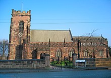
In medieval times Frodsham was an important borough and port belonging to the Earls of Chester.[citation needed] Its parish church, St. Laurence's, still exhibits evidence of a building present in the 12th century in its nave[citation needed] and is referenced in Domesday Book.
A market is held each Thursday, and Frodsham's viability as a trading centre was emphasised by the presence of the "big five" clearing banks and several building societies, though the branches of HSBC and NatWest have recently closed.
Development in the town's shops and premises with alcohol licences is evident through the recent (post-2002) opening or modernisation of contemporary-style bar/restaurants, take-away food shops and public houses, and in the continued presence of small, specialised, businesses operating from town-centre shops.
History[]
Etymology[]
The etymology of Frodsham's name is not entirely clear. A literal translation of the Old English would give personal name of Frod or an old spelling of Ford, and ham which means a village or homestead; hence Frod's village or the Village on the Ford (Ford-ham). However, an alternative, more obscure etymology exists which suggests the name means "promontory into marsh", which would make sense considering that Frodsham had a promontory castle very close to marshland. Frodsham is unique as the name of a settlement in the British Isles.[3][4] Earlier spellings of the name have included Fradsham, Frandsham, Frodisham, Ffradsam and Ffradsham.[5]
Early history[]
Frodsham Hill is the location of an Iron Age promontory fort, the outline of which can still be seen.[6]
The town is of Saxon origin; its 11th-century church is mentioned in the Domesday Book. Frodsham was an important manor of the medieval Earls of Chester and was created a borough in the early 13th century, probably by Earl Ranulf III. The mouth of the River Weaver, where it joins the Mersey, made Frodsham into a significant port for the coasting trade, particularly for the export of Cheshire salt, brought down the river from Northwich and Nantwich. The site of the manor house was in Castle Park; the building was of stone and was fortified. In an account of 1315 it is called 'castellum' (little castle), although 'manerium' (manor house) was the usual designation.
Recent history[]
Frodsham was the headquarters of Runcorn Rural District Council. In 1974 the district was split between Halton Borough Council, Warrington Borough Council and Vale Royal District Council (latterly Vale Royal Borough Council). In the early 1990s Vale Royal Borough Council opened a new purpose-built headquarters in Winsford. At the same time, its offices in Hartford near Northwich (the former headquarters of Northwich Rural District Council) and at Castle Park in Frodsham (the former headquarters of Runcorn Rural District Council) were downgraded.
Castle Park House had a major refurbishment in 2005–06 and now operates as a "one-stop shop" for Cheshire West and Chester Council providing a number of services for the community and for businesses.

In 1992 the parish council became Frodsham Town Council and Frodsham was no longer a village. The chair of the parish council became the mayor of Frodsham. The majority of powers were held by Cheshire County Council and Vale Royal Borough Council who were replaced by Cheshire West and Chester Council on 1 April 2009.
Frodsham was home to Frodsham School, a science and technology college, which closed in July 2009 due to the falling birth rate and amalgamated with Helsby High School. The site was redeveloped and now houses the new health centre for the town.
Frodsham, like the neighbouring village of Helsby, has a hill overlooking the Mersey estuary, which is popular with dog walkers and naturalists. Frodsham Hill, overlooking Frodsham and the Liverpool skyline, is a large sandstone hill, home to many farms, prestige homes and the Mersey View nightclub (commonly known as 'the View') and Forest Hills Hotel. Before the construction of the hotel and nightclub, famously hosting one of the Beatles' first appearances, the site was home to a very large helter skelter.
The Frodsham Caves are found in the sandstone foundations of Frodsham Hill.
Geography[]
Frodsham sits beneath the imposing wooded escarpment of Beacon Hill, which is also known locally as Frodsham Hill or Overton Hill and whose top attains a height of just over 500 feet (152 m). The hill forms the northern end of the Mid-Cheshire Ridge, a range of sandstone hills that extends southwards to Delamere Forest and Tarporley.
The northern boundaries of the modern parish are defined by the River Weaver (canalised in part as the Weaver Navigation) and the inner Mersey Estuary into which it flows. The Manchester Ship Canal runs parallel to the Mersey along the northern edge of the low-lying ground of Frodsham Marsh and Lordship Marsh, which themselves extend south and east to the built-up area of Frodsham.
The town is close to the junction of the A56, the main link between Chester and Warrington, with the B5152 road, which runs southeast to connect with Kingsley, Northwich and Tarporley in the centre of the county. The Chester–Manchester railway line passes through the town and the M56 motorway runs parallel to the road and railway along the southeastern edge of the marsh. The formerly separate settlements of Netherton and Overton form the southern districts of the town while the easternmost section towards Frodsham Bridge is known as Newtown.[7]
Geology[]
The parish, like most in Cheshire, is underlain by a suite of sedimentary rocks dating from the Triassic Period. They comprise (in ascending order) the Lower Triassic age Kinnerton Sandstone, Chester Pebble Beds and Wilmslow Sandstone Formations together with the upper Triassic age Helsby Sandstone, Tarporley Siltstone and Sidmouth Mudstone Formations. Those formations up to and including the Helsby Sandstone Formation are assigned to the Sherwood Sandstone Group. It is this formation whose relatively hard-wearing sandstones form the higher ground of Beacon Hill, Woodhouse Hill and Harrol Edge. The younger siltstones and mudstones are assigned to the Mercia Mudstone Group.[8] The sequence of sandstones is exposed in a railway cutting and two road cuttings, which are designated as an earth sciences Site of Special Scientific Interest.[9][10]
Several faults run roughly northwest–southeast through the area, notably the Overton Fault, which roughly parallels the B5439 and B5152 roads, and the Frodsham Fault, which runs north from the vicinity of Crowmere to the mouth of the River Weaver. Both of these faults and others in the area downthrow to the east. Movement on them is thought to have taken place in the Tertiary period. The uplift resulted in trapping the water table at an elevation of around 200 feet (61 m) at which level springs developed.[11]
Overlying the bedrock is a variety of superficial deposits (otherwise known as drift). These comprise a thin and patchy cover of glacial till (or 'boulder clay'), largely a legacy of the last ice age, together with spreads of glacio-fluvial sand and gravel, a product of the eventual deglaciation of the area. Recent alluvium fills the deeply incised valley of the Weaver and also extends across the Marsh to the Mersey estuary.[8][12]
Climate[]
Being close to the west coast and the Irish Sea, the climate is generally temperate with few extremes of temperature or weather. The mean average temperature in the years 1971 to 2000 was 9.4 to 9.7 °C, slightly above the average for the United Kingdom[13] as was the average amount of annual sunshine at 1391 to 1470 hours.[14] The average annual rainfall was 741 to 870 mm, slightly below the average for the UK.[15] The average number of days in the year when snow is on the ground is 0 to 6, which is low for the United Kingdom.[16] The average number of days of air frost is 2 to 39, which is also low.[17]
Transport[]
There is a railway station in Frodsham which is managed by Transport for Wales.[18] It runs an hourly service between Manchester Piccadilly and Llandudno via Frodsham and Chester. There are also infrequent services by Northern between Ellesmere Port and Helsby.[19]
Bus services are available to Chester, Runcorn, Ellesmere Port, Hatchmere (adjacent to Delamere Forest) and to Northwich.[20] Frodsham is 14 miles (23 km) from Liverpool John Lennon Airport and 22 miles (35 km) from Manchester Airport.
Education[]
There are four primary schools in Frodsham, namely Frodsham Manor House Primary School, St Luke's Catholic Primary School, Frodsham Church of England Primary School and Frodsham Weaver Vale Primary School.[21] The only secondary school in the town, Frodsham School, a science and technology college, has now closed[22] and has been converted into a health clinic, library and leisure centre.
Religion[]
There is one Anglican church in Frodsham, St Laurence's on Church Road, Overton. Frodsham Methodist Church is on Kingsley Road, also just outside the centre of Frodsham in the Five Crosses/Overton area of the town. The town has, in the past, had a number of Methodist churches built to replace older chapels. Most recent to close were Trinity Wesleyan Methodist Chapel (later Trinity Methodist Church) and Bourne Primitive Methodist Chapel (later Bourne Methodist Church). The spire of Trinity is still a visible landmark in the town.[23] The Roman Catholic church is St. Luke's in High Street. There are two Evangelical chapels, Main Street Community Church and King's Church (Free Methodist) on Chester Road.[24]

Local government arrangements[]
Frodsham lies within the administrative area of Cheshire West and Chester Council. Two councillors are elected from the Frodsham ward to serve on that Council. The Frodsham ward has the same boundaries as the Town's own parish boundaries. The current Councillors are Cllr Andrew Dawson and Cllr Lynn Riley, both Conservatives, who were both elected to serve a four-year term of office in May 2011 and again in May 2015.
Frodsham Town Council is the local council or parish council for Frodsham. This council is made up of 16 councillors. The town councillors are elected from one of four parish wards called Waterside Ward, Lakes Ward, Overton & Five Crosses Ward and Castle Park Ward. Four Councillors are elected from each ward. These Town Councillors are elected to serve four-year terms of office, the most recent elections being on 7 May 2015. If any vacancy occurs during the four-year term 10 local parishioners from the relevant ward can require a by-election to be held, otherwise the other Town Councillors can co-opt an eligible person to be a Councillor. The last by-election occurred in September 2013 in West ward. The last co-option occurred in September 2011 in North ward.[25]
The then Frodsham parish council resolved to style itself a town in 1992. From 1992 to May 2012 the chairman of the council has served as the Town Mayor but using the courtesy title of 'Mayor of Frodsham'. However, strictly, the chairman is only entitled to be known as 'town mayor'.
In April 2012 the council resolved to split the roles of chairman and Mayor of Frodsham and separate votes are now held for each position. The council also resolved to create a convention offering the mayorship to the councillor who had served the longest since last being Mayor, or having been first elected regardless of any political or personal affiliations.
Media[]
In November 2014 Frodsham made national headlines due to a hoax in which it was claimed that actor William Shatner would be turning on the town's Christmas lights.[26][27] A Twitter account, @Frodshamxmas, having spent the preceding weeks presenting itself as (though never directly claiming to be) the official social media account for the town's festivities, tweeted that the Star Trek actor would be making an appearance.[28] Several local news outlets, local councillors and the local MP unwittingly retweeted the claims until Shatner issued a tweet confirming them to be false.[29] The perpetrator(s) of the hoax have never come forward.
Notable people[]


- Bridge Frodsham (1734–1768) was an English actor, born in Frodsham [30]
- William Charles Cotton (1813–79), who introduced beekeeping to New Zealand, was vicar of Frodsham 1859–1879.[31]
- Holbrook Gaskell II (1846–1919) a chemical industrialist, he died at his house Erindale in Frodsham
- Harriet Shaw Weaver (1876–1961), feminist political activist and patron of James Joyce, was born in Frodsham.[32]
- Bob Carolgees (b. 1948), 1980s TV entertainer, owns a candle shop at the Lady Hayes Craft Centre, near Frodsham.[33]
- Patrick Larley (b. 1951), classical composer, conductor, organist and solo singer, was born in the town.[34]
- Caradog Jones (b. 1962), the first Welshman to reach the summit of Mount Everest, lives in Frodsham.[35]
- Paul Marsden (b. 1968), former MP for Shrewsbury and Atcham 1997 to 2005, was born in Frodsham.[36]
- Alice Coote (b. 1968) mezzo-soprano was born in Frodsham.[37]
- Daniel Craig (b. 1968), actor, lived in Frodsham from 1972 to his early teens, at the Ring o' Bells pub where his father was landlord.[38]
- Gary Barlow (b. 1971), singer, pianist, songwriter and producer, was born in Frodsham.[39]
- Emma Cunniffe (b. 1973) is a British film, stage and television actress.[40]
- Djibril Cissé (b. 1981), ex-Liverpool, Sunderland and France footballer, lived in the town as Lord of the Manor of Frodsham.[41]
See also[]
- Bear's Paw Hotel, Frodsham
- Frodsham Castle
- Frodsham railway station
- Frodsham School
- Listed buildings in Frodsham
- St Laurence's Church, Frodsham
References[]
Notes[]
- ^ Jump up to: a b UK Census (2011). "Local Area Report – Frodsham Parish (E04011099)". Nomis. Office for National Statistics. Retrieved 26 May 2020.
- ^ Office for National Statistics : Census 2001 : Parish Headcounts : Vale Royal. Retrieved 15 December 2009.
- ^ The exact quote in Latham page 14 reads: "Frodsham is unique in the British Isles in that the name does not occur anywhere else."
- ^ Though a nearby township was referred to during the period of the ancient parishes of Cheshire as "Newton by Frodsham", its current name is now just "Newton". See Dunn, F. I. (1987), page 27, which states that, at the time, the Newton township near to Frodsham was referred to as "Newton by Frodsham". Furthermore, see Ordnance Survey (2004), which refers to the modern settlement which was Newton by Frodsham township just as "Newton" without any Frodsham component: SJ531751
- ^ Latham 1987, p. 14.
- ^ Historic England. "Monument No. 71527". Research records (formerly PastScape). Retrieved 28 November 2017.
- ^ Ordnance Survey, Explorer map sheet 267
- ^ Jump up to: a b Phillips & Phillips 2002, pp. 4–5.
- ^ Natural England: Frodsham Railway And Road Cuttings . Retrieved 16 April 2010.
- ^ Natural England: Nature on the Map: Frodsham Railway & Road Cuttings SSSI . Retrieved 16 April 2010.
- ^ Dodd 1987, p. 4.
- ^ British Geological Survey 1:50K map sheet 97, 'Runcorn'
- ^ Mean Temperature: Annual Average 1971–2000, Met Office, archived from the original on 3 February 2012, retrieved 22 May 2007
- ^ Sunshine Duration: Annual Average 1971–2000, Met Office, archived from the original on 4 February 2012, retrieved 22 May 2007
- ^ Rainfall Amount: Annual Average 1971–2000, Met Office, archived from the original on 19 July 2013, retrieved 22 May 2007
- ^ Days of Snow Lying: Annual Average 1971–2000, Met Office, archived from the original on 9 August 2007, retrieved 22 May 2007
- ^ Days of Air Frost: Annual Average 1971–2000, Met Office, archived from the original on 5 July 2007, retrieved 22 May 2007
- ^ Station Facilities: Frodsham (FRD), National Rail Enquiries, retrieved 17 May 2007
- ^ Timetable (PDF), Northern Railway, retrieved 30 November 2017
- ^ Bus Service Timetables, Cheshire West and Chester, archived from the original on 6 September 2010, retrieved 7 July 2010
- ^ Schools in the Vale Royal area, Vale Royal Borough Council, archived from the original on 13 August 2007, retrieved 17 May 2007
- ^ Ellams, Barry (16 July 2009), "Frodsham High School to close on Friday", Chester Chronicle, Trinity Mirror North West & North Wales, retrieved 7 July 2010
- ^ Frodsham Methodist Church. "Church History". Frodsham Methodist Church. Frodsham Methodist Church. Retrieved 19 April 2020.
- ^ Churches in Frodsham, Frodsham Churches Together, retrieved 31 January 2017
- ^ Frodsham Town Council www.frodsham.gov.uk, accessed 12 August 2021
- ^ Hall, Melanie (25 November 2014). "William Shatner denies 'boldly going' to turn on Cheshire town's Christmas lights after rumbling hoax". The Daily Telegraph. ISSN 0307-1235. Retrieved 18 December 2017.
- ^ "Captain Kirk not trekking to Cheshire". BBC News. 25 November 2014. Retrieved 18 December 2017.
- ^ "Frodsham Xmas 2014 (@Frodshamxmas) | Twitter". twitter.com. Retrieved 18 December 2017.
- ^ Shatner, William (24 November 2014). "The village of Frodsham UK is promising I will turn on holiday lights? There's a reason why the word Sham is in the name! Sorry, not true". @williamshatner. Retrieved 18 December 2017.
- ^ Dictionary of National Biography, 1885-1900, Volume 20, Frodsham, Bridge retrieved 14 July 2018
- ^ Smith, Arthur R. (2006), William Charles Cotton MA: Priest, Missionary and Bee Master, Birkenhead: Countyvise, ISBN 1-901231-81-X
- ^ Cottam, Rachel (2004) 'Weaver, Harriet Shaw (1876–1961), Oxford Dictionary of National Biography, Oxford University Press, [1] Retrieved on 9 March 2007
- ^ Why you should move to Frodsham, Archant Life Limited, archived from the original on 5 July 2008, retrieved 7 October 2008
- ^ "Patrick Larley: Biography", Patrick Larley, www.patricklarley.com, archived from the original on 4 March 2016, retrieved 11 June 2008
- ^ Garfield, Simon (30 March 2003), "High society", The Observer, London: Guardian News and Media Limited, retrieved 7 October 2008
- ^ BBC Profile of Paul Marsden
- ^ Barnett, Laura (16 August 2010), "Portrait of the artist: Alice Coote, mezzo-soprano", The Guardian, Guardian News and Media, retrieved 24 March 2015
- ^ Daniel Craig (I) – Biography
- ^ Gary Barlow: Official website, www.garybarlow.com, retrieved 2 October 2008 (One needs to choose the biography section after the animated introduction finishes.)
- ^ Flint, Rachel (17 February 2011). "Frodsham born Emma Cunniffe will be performing in Ibsen's ground-breaking play A Doll's House". Chester Chronicle. Chester. Retrieved 17 February 2011.
- ^ Herbert, Ian (19 May 2005), The Independent: Football's lord of the manor bans hunting on his nine acres, London: Independent News and Media Limited, retrieved 6 October 2008
Bibliography[]
- Dodd, J. Phillip (1987), A History of Frodsham and Helsby, Frodsham: J. Phillip Dodd
- Dunn, F. I. (1987), The ancient parishes, townships and chapelries of Cheshire, Chester: Cheshire Record Office and Cheshire Diocesan Record Office, ISBN 0-906758-14-9
- Latham, F. A. (ed.) (1987), Frodsham, Frodsham: Local Historians, ISBN 0-901993-06-9CS1 maint: extra text: authors list (link)
- Ordnance Survey. (2004). Northwich and Delamere Forest, Winsford and Middlewich. (1:25000 scale map). Southampton United Kingdom: Ordnance Survey. ISBN 0-319-23567-X.
- Phillips, A.D.M.; Phillips, C.B. (2002), A New Historical Atlas of Cheshire, Chester: Cheshire County Council, ISBN 0-904532-46-1
External links[]
| Wikimedia Commons has media related to Frodsham. |
| show |
|---|
| Authority control |
|
|---|
- Frodsham
- Towns in Cheshire
- Market towns in Cheshire
- Civil parishes in Cheshire
- Cheshire West and Chester