Crindau
This article needs additional citations for verification. (December 2009) |
| Crindau | |
|---|---|
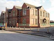 Crindau Primary School | |
| Population | 5,000 approx. |
| OS grid reference | ST295885 |
| Principal area | |
| Country | Wales |
| Sovereign state | United Kingdom |
| Post town | NEWPORT |
| Postcode district | NP20 5 |
| Dialling code | 01633 Savoy exchange |
| Police | Gwent |
| Fire | South Wales |
| Ambulance | Welsh |
| UK Parliament | |

Crindau (Welsh: Crindai) is an older inner-city area just north of the city centre in Newport in south-east Wales. It lies within the Shaftesbury electoral district (ward) and community (parish).
Crindau is roughly bounded by the Monmouthshire canal to the west, the M4 motorway to the north, River Usk to the east and South Wales Main Line to the south. It is bisected by the elevated section of the A4042 road. The district is well-served in transport terms as it contains junction 26 and 25a of the M4 as well as the A4042 and A4051 roads. There is a regular Newport Bus service from Malpas and Bettws to the city centre.
To the eastern side, adjoining the river is Shaftesbury Park, which was the original home of Newport Rugby Club before they moved to the Newport Athletics and Cricket Club site at Rodney Parade.
A cycle and pedestrian walkway alongside the River Usk links Newport city centre to the centre of Caerleon along National Cycle Route 88. There is a marked heritage trail in Caerleon.
Crindau is well served by a number of churches providing a cross-section of Christian traditions including Malpas Road Evangelical Church, Crindau Community Church,[1] Shaftesbury Methodist Church and All Saints Church.
History[]
Until 1875 the area was mostly marshland with the northern artery road of Newport running through it. Crindau House, an Elizabethan manor, was the only residence. After the Borough Extension Act of 1876 and the Marshes Road rebuilt Newport Corporation began construction of the Marshes estate, streets named after Newport mayors and was completed in 1901, the remainder of the land becoming Shaftesbury Park. More land was acquired to the north of Crindau Pill, along the eastern side of the railway, and a gas and glass works were opened in 1886. The same year the Newport Workmens Cottage Company was established and built houses inbetween the works and the Marshes. Development followed into the 1890's on the western side of the railway, on what has now become Malpas Road. A confectionery works, Lovell's, was established in around 1910 on Albany Street and in 1918 its football team was founded with its own ground on the works site, Rexville.
Post-war redevelopments in the 1960's such as the M4 motorway and old housing clearances in the 1970's changed the landscape of Crindau. The Malpas Road Relief Scheme in the 1990's follows the route of the railway. Closed industries such as the glass, gas and confectionery works were redeveloped and a new flood defence scheme was completed in 2021 (the area having been notoriously subjected to flooding for hundreds of years).
References[]
- ^ "Crindau Community Church". Retrieved 21 March 2016.

Coordinates: 51°35′58″N 2°59′42″W / 51.59944°N 2.99500°W
This Newport location article is a stub. You can help Wikipedia by . |
- Districts of Newport, Wales
- Newport, Wales geography stubs