Langstone, Newport
This article uses bare URLs, which may be threatened by link rot. (May 2021) |
This article needs additional citations for verification. (July 2014) |
| Langstone | |
|---|---|
 Langstone parish church | |
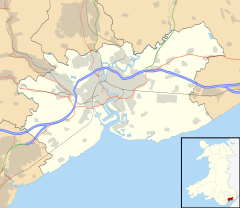
 Langstone Location within Newport | |
| Population | 4,425 (2011 census)[1] |
| OS grid reference | ST386909 |
| Principal area | |
| Country | Wales |
| Sovereign state | United Kingdom |
| Post town | NEWPORT |
| Postcode district | NP18 2 |
| Postcode district | NP26 3 |
| Dialling code | 01633 Llanwern exchange Penhow exchange |
| Police | Gwent |
| Fire | South Wales |
| Ambulance | Welsh |
| UK Parliament | |
Langstone is an electoral ward and smaller village and community of the city of Newport, Wales. The area is governed by the Newport City Council. The community had a population of 3,279 in 2011.[2]
Location[]
Langstone is situated on the eastern edge of the city and is one of Newport's more affluent areas, less than a mile from Junction 24 (Coldra) of the M4 motorway. Some of the ward is hilly and heavily forested. It is bounded to the north and east by the city boundary, to the west by the Caerleon ward and to the south west by the Ringland and Llanwern wards.
Development[]
The original village was a small linear settlement along the A48 (Chepstow Road) and its offshoot, Tregarn Road. Since the 1990s, many have moved to the area because of its appeal as being rural, but also minutes away from the M4 motorway. This population influx in the '90s resulted in the construction of a large housing development at the bottom of Cat's Ash Road, together with developments of housing estates, big and small, along Tregarn Road and Magor Road.
The ward contains the parishes of Penhow and Llanvaches, as well as the parish of Langstone (population 2,770[3]). The parish itself contains the hamlets of Llanbeder, Llandevaud and Llanmartin as well as Langstone itself.
History[]
The actual village of Langstone (excluding the adjoining villages of Penhow-Parc Seymour, Llanvaches, Llandevaud, Llanbedr and Llanmartin) in 1801 had 126 inhabitants. By 1901 the population had risen to 206. The United Kingdom Census 2001 recorded the population as 3,905 people.
In 1891 Kelly's Directory of Monmouthshire noted that Llanbedr was a hamlet, one and a half miles north-east of the parish, on the road from Newport to Chepstow. There were some remains of a church there, being then used as a barn.[4]
In July 2018, after a long period of warm dry weather, crop marks of a prehistoric or Roman farm near the village were revealed. The site was recorded by the Royal Commission on the Ancient and Historical Monuments of Wales (RCAHMW) before it disappeared again with the next rains.[5]
The parish church has 13th-century origins. In 1622 the nave was extended after the south porch, which is probably 16th-century. The church was restored in 1907 and north and south chapels to the chancel probably date from this time. It is a Grade II listed building.[6] It is part of the Magor Ministry. It has no known patron saint.[7]
Scheduled Ancient Monuments[]
The Schedule of Ancient Monuments has 11 entries for the Langstone ward:
- Kemeys Inferior Motte and Bailey castle
- Pen-Toppen-Ash Roman marching camp
- Caer Licyn
- Pencoed Castle
- Langstone Villa moated site
- Langstone Mound and Bailey Castle - discovered in 1964 during construction of the M4 motorway.
- A round barrow 57m south of Stock Wood
- All Saints' Church, Kemeys Inferior[8]
- St Curig's chapel (remains of), Catsash[9]
- Moated site 200m south west of Court Farm
- Moated site 250m south west of Pencoed Castle
Both Pencoed Castle and Penhow Castle fall within the boundaries of Langstone ward. Penhow Castle is privately owned. The area is also home to Penhow Quarry, owned by Hanson plc.
Amenities[]
Langstone Primary School celebrated its 50th birthday in 2004, and currently has about 300 pupils. Until the 1970s the school intake stretched as far as Nash, Goldcliff, Whitson, Llanwern, Bishton and Llandevaud. The school it is now well over capacity, however, serving simply Langstone and its surrounds.[10]
Pupils receiving a Welsh medium education have the Welsh Medium Ysgol Gymraeg Casnewydd as their local school
The MP for Newport East, which includes Langstone, is Jessica Morden (Labour) who assumed office in 2005. The National Assembly for Wales Assembly member is Jeff Cuthbert, who assumed office in 2004 and is also a Government Minister for Skills in the Welsh Government. (Education, being a devolved matter, independent of England's education system)
References[]
- ^ "Newport ward 2011". Retrieved 4 April 2015.
- ^ "Custom report - Nomis - Official Labour Market Statistics".
- ^ "Local statistics - Office for National Statistics". www.neighbourhood.statistics.gov.uk. Retrieved 10 July 2018.
- ^ "Ancestry® - Genealogy, Family Trees & Family History Records". freepages.genealogy.rootsweb.ancestry.com. Retrieved 10 July 2018.
- ^ [1]
- ^ "Parish Church of Langstone, Langstone, Newport".
- ^ "Langstone Church – Magor Ministry Area".
- ^ [2]
- ^ [3]
- ^ Council, Newport City. "Langstone Primary School, Newport". www.langstoneprimary.co.uk. Retrieved 10 July 2018.
External links[]
| Wikimedia Commons has media related to Langstone, Newport. |
- http://www.steplearn.net/langstone/ - Langstone Primary School website
- Photos of Langstone and surrounding areas
- http://www.newportlearn.net/ysgol/ - Ysgol Gymraeg Casnewydd website
- Communities in Newport, Wales
- Wards of Newport, Wales
- Villages in Newport, Wales

