Cross Plains, Tennessee
Cross Plains, Tennessee | |
|---|---|
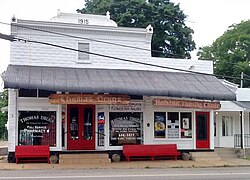 Thomas Drugs in Cross Plains | |
 Location of Cross Plains in Robertson County, Tennessee. | |
 Cross Plains Location within Tennessee | |
| Coordinates: 36°32′42″N 86°40′27″W / 36.54500°N 86.67417°WCoordinates: 36°32′42″N 86°40′27″W / 36.54500°N 86.67417°W | |
| Country | United States |
| State | Tennessee |
| County | Robertson |
| Government | |
| • Mayor | Barry Faulkner |
| Area | |
| • Total | 8.69 sq mi (22.51 km2) |
| • Land | 8.69 sq mi (22.51 km2) |
| • Water | 0.00 sq mi (0.00 km2) |
| Elevation | 745 ft (227 m) |
| Population (2010) | |
| • Total | 1,714 |
| • Estimate (2019)[4] | 1,827 |
| • Density | 210.27/sq mi (81.18/km2) |
| Time zone | UTC-6 (Central (CST)) |
| • Summer (DST) | UTC-5 (CDT) |
| ZIP code | 37049 |
| Area code(s) | 615 |
| FIPS code | 47-18420[2] |
| GNIS feature ID | 1306195[3] |


Cross Plains is a city in Robertson County, Tennessee. The city's population was 1,714 at the 2010 census.[5] Cross Plains was the first area of Robertson County that was settled by European settlers, with the arrival of Thomas Kilgore in 1778.
History[]
In 1778, American Revolutionary War veteran Thomas Kilgore arrived at the Middle Fork of Red River, three-fourths of a mile west of Cross Plains, making him the first European settler to arrive in Robertson County.[6] Kilgore traveled to this area to claim 640 acres of land, which was guaranteed to settlers who traveled west by the Legislature of North Carolina.[7] Kilgore returned to eastern North Carolina in the fall of 1778, and after the title of his land was confirmed, he traveled back to his settlement with a few other families, and built a stockade which would be known as Kilgore Station.[8] The first building was a double log house erected by William Randolph in 1819. It was also used as a tavern.
In 1915, A drug store called Thomas Drugs opened, which is one of the oldest establishments in Cross Plains.
In 2004, Construction began on a park named "Kilgore Park" located beside East Robertson High School. Construction was completed in 2008. On August 20, 2020, the Cross Plains city government announced that they had purchased 148 acres of land on Highway 25 west of Kilgore Park for $1.08 million. City officials stated that the land was purchased for future uses such as an expansion of Kilgore Park, or new schools.[9]
Education[]
East Robertson Elementary School (Pre-K–5th) and East Robertson High School (6-12) are the two public schools of Cross Plains, Tennessee.
Geography[]
Cross Plains is located at 36°32′42″N 86°40′27″W / 36.544912°N 86.674260°W.[10]
According to the United States Census Bureau, the city has a total area of 8.3 square miles (21 km2), all land.
Transportation[]
Highways
 Interstate 65
 U.S. Highway 31W
 Tennessee State Route 25
Access to Interstate 65 provided by Exit 108 from SR 25. US 31W runs parallel to I-65.
Demographics[]
| Historical population | |||
|---|---|---|---|
| Census | Pop. | %± | |
| 1880 | 101 | — | |
| 1980 | 655 | — | |
| 1990 | 1,025 | 56.5% | |
| 2000 | 1,381 | 34.7% | |
| 2010 | 1,714 | 24.1% | |
| 2019 (est.) | 1,827 | [4] | 6.6% |
| Sources:[11][12] | |||
As of the census[2] of 2000, there were 1,381 people, 504 households, and 400 families residing in the city. The population density was 166.8 people per square mile (64.4/km2). There were 536 housing units at an average density of 64.7 per square mile (25.0/km2). The racial makeup of the city was 94.06% White, 3.19% African American, 0.22% Native American, 0.14% Asian, 0.14% Pacific Islander, 0.22% from other races, and 2.03% from two or more races. Hispanic or Latino of any race were 1.23% of the population.
There were 504 households, out of which 36.7% had children under the age of 18 living with them, 63.1% were married couples living together, 11.1% had a female householder with no husband present, and 20.6% were non-families. 16.5% of all households were made up of individuals, and 6.0% had someone living alone who was 65 years of age or older. The average household size was 2.74 and the average family size was 3.06.
In the city, the population was spread out, with 27.4% under the age of 18, 7.0% from 18 to 24, 30.1% from 25 to 44, 26.2% from 45 to 64, and 9.3% who were 65 years of age or older. The median age was 37 years. For every 100 females, there were 106.7 males. For every 100 females age 18 and over, there were 101.4 males.
The median income for a household in the city was $42,279, and the median income for a family was $47,143. Males had a median income of $37,424 versus $24,792 for females. The per capita income for the city was $17,792. About 8.1% of families and 12.0% of the population were below the poverty line, including 17.9% of those under age 18 and 20.6% of those age 65 or over.
References[]
- ^ "2019 U.S. Gazetteer Files". United States Census Bureau. Retrieved July 30, 2020.
- ^ Jump up to: a b "U.S. Census website". United States Census Bureau. Retrieved 2008-01-31.
- ^ "US Board on Geographic Names". United States Geological Survey. 2007-10-25. Retrieved 2008-01-31.
- ^ Jump up to: a b "Population and Housing Unit Estimates". United States Census Bureau. May 24, 2020. Retrieved May 27, 2020.
- ^ Tennessee Department of Economic and Community Development, Certified Population of Tennessee Incorporated Municipalities and Counties Archived 2014-06-30 at the Wayback Machine, State of Tennessee official website, 14 July 2011. Retrieved: 6 December 2013.
- ^ "Early History of Robertson County, Tennessee". bellwitch.org. bellwitch.org. Retrieved August 16, 2020.
- ^ Goodspeed's History of Tennessee (PDF). Goodspeed Publishing. 1886. p. 2. Retrieved August 16, 2020.
- ^ "Thomas Kilgore". Facebook. Robertson County Historical Society. Retrieved August 16, 2020.
- ^ "CROSS PLAINS ANNOUNCES 148 ACRE LAND ACQUISITION". Smokey Barn News. Smokey Barn News. August 20, 2020. Retrieved August 20, 2020.
- ^ "US Gazetteer files: 2010, 2000, and 1990". United States Census Bureau. 2011-02-12. Retrieved 2011-04-23.
- ^ "Census of Population and Housing: Decennial Censuses". United States Census Bureau. Retrieved 2012-03-04.
- ^ "Incorporated Places and Minor Civil Divisions Datasets: Subcounty Resident Population Estimates: April 1, 2010 to July 1, 2012". Population Estimates. U.S. Census Bureau. Archived from the original on June 11, 2013. Retrieved 11 December 2013.
External links[]
| show Municipalities and communities of Robertson County, Tennessee, United States |
|---|
| show Authority control |
|---|
- Cities in Tennessee
- Cities in Robertson County, Tennessee
- Populated places established in 1819