Cypress Hills Interprovincial Park
| Cypress Hills Interprovincial Park | |
|---|---|
 Cypress Hills | |
 Location of Cypress Hills Interprovincial Park in Canada | |
| Location | Cypress County, Alberta/Maple Creek No. 111, Saskatchewan, Canada |
| Nearest city | Medicine Hat, AB; Swift Current, SK |
| Coordinates | 49°34′31″N 110°00′23″W / 49.57528°N 110.00639°WCoordinates: 49°34′31″N 110°00′23″W / 49.57528°N 110.00639°W |
| Area | 400 km2 (150 sq mi) |
| Established | 1951 (Alberta) 1989 (interprovincial) |
| Governing body | Alberta Environment and Parks and Ministry of Parks, Culture and Sport (Saskatchewan) |

Cypress Hills Interprovincial Park is a natural park in Canada straddling the Alberta-Saskatchewan boundary and jointly administered by the two provinces. Located southeast of Medicine Hat, it became Canada's first interprovincial park in 1989.
The park consists of two protected areas, the 345 km2 (133 sq mi) west block, that straddles the Alberta/Saskatchewan boundary between Alberta Highway 41, the townsite of Elkwater, Saskatchewan Highway 615, Saskatchewan Highway 271 and Fort Walsh, and the centre block, an additional area of 58 km2 (22 sq mi) in Saskatchewan, west of Saskatchewan Highway 21.
Geography[]
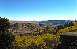
The Cypress Hills plateau rises up to 200 metres above the surrounding prairie, to a maximum elevation of 1,468 metres (4,816 ft) at "Head of the Mountain" at the west end in Alberta,[1] making it Canada's highest point between the Canadian Rockies and the Labrador peninsula. Eastward across the boundary is the highest point in Saskatchewan, at 1,392 metres (4,567 ft).[2] The "West Block" of the Cypress Hills spans the provincial boundary. Battle Creek runs through the central part of the park. Although the hills seem relatively low, in a larger geographic context the plateau does rise gradually from many kilometres away so that the total elevation gain from Medicine Hat is approximately 600 metres.
Nature[]
Approximately 700 species of plants and animals thrive in the park, including 14 species of orchids.
There are 5 species of large hoofed mammals found in the park:[3] Wapiti, Mule Deer, White-tailed Deer, and Pronghorn.
Other mammals found in Cypress Hills Interprovincial Park include:[3]
| Insectivora | Chiroptera | Carnivora | Rodentia | ||
|---|---|---|---|---|---|
| Masked Shrew | Little Brown Myotis | Raccoon | Least Weasel | Richardson's Ground Squirrel | Northern Grasshopper Mouse |
| Wandering Shrew | Long-earned Myotis | Long-tailed Weasel | Thirteen-lined Ground Squirrel | Deer Mouse | |
| Pygmy Shrew | Small-footed Myotis | Black-footer Gerret | Black-tailed Prairie Dog | White-footed Mouse | |
| Silver-haired Bat | Swift Fox | Mink | Least Chipmunk | Bushy-tailed Wood Rat | |
| Lagomorpha | Big Brown Bat | Coyote | River Otter | Red Squirrel | Gapper's Red-Back Mouse |
| White-tailed Jack Rabbit | Hoary Bat | Striped Skunk | Northern Pocket Gopher | Meadow Vole | |
| Snowshoe Rabbit | Red Bat | Ermine | Badger | Olive-backed Pocket Mouse | Sagebrush Vole |
| Nuttall's Conttontail | Mountain Lion | Bobcat | Ord's Kangaroo Rat | Muskrat | |
| Beaver | Western Jumping Mouse | ||||
| Porcupine | |||||
The park protects the majority of the Cypress Hills landscape, which consists of three separate elevated blocks of lush forest and fescue grassland surrounded by dry mixed-grass prairie. The "west block" and "centre block" are protected as provincial parks, and are managed by Alberta Parks and Protected Areas[4] and Saskatchewan Parks,[5] respectively. The "east block" of the Cypress Hills, situated near Eastend, Saskatchewan, is not a park or protected area. The Fort Walsh National Historic Site is also located adjacent to the "west block".
Fish species[]
Fish species include walleye, yellow perch, northern pike, brook, brown, westslope cutthroat and rainbow trout, burbot, common carp, white sucker, and shorthead redhorse.
Activities[]

On the Alberta side of the west block, key park features include Head of the Mountain Viewpoint, the highest point between the Rocky Mountains and Labrador, the Elkwater townsite (a cottage community sitting at the same elevation as the Banff townsite), Horseshoe Canyon and Reesor Lake viewpoints (offering 100 km views on a clear day), over 50 km of hiking and mountain biking trails, and Hidden Valley Ski Area. Three lakes sit on the Alberta side of the park (Elkwater Lake, Spruce Coulee Reservoir and Reesor Lake), with another four in Saskatchewan (Harris, Adams, Coulee Lake and Loch Leven).
All year long, park interpreters present education programs to school and youth groups, adult and seniors groups, and a wide range of park visitors.
There are also various rentals to be used in the park in the various months. In summertime, kayak, canoe, bicycle, and stand up paddle boards are available for rental. In the winter, kicksleds, snowshoes, skates and cross country skis may be rented.
History[]

- 1951 - The Cypress Hills Provincial Park was established in Alberta.
- 1989 - On August 25, the governments of Alberta[6] and Saskatchewan[7] signed an agreement committing themselves to cooperation on ecosystem management, education and park promotion.
- 2000 - Fort Walsh National Historic Site (located on the Saskatchewan side of the West Block) joined the collective. Together, these three partner agencies make up the park. Both Alberta and Saskatchewan provincial governments signed the Cypress Hills Interprovincial Park agreement, establishing the first interprovincial park in Canada.
- 2001 - On August 18, Vance Petriew discovered a comet from Cypress Hills during the Saskatchewan Summer Star Party.[8] The comet was later named 185P/Petriew.
- 2004 - On September 28, Saskatchewan Parks, Alberta Community Development, Parks Canada and the Royal Astronomical Society of Canada signed an agreement that declared the park a dark-sky preserve.
- 2011 - On August 25, the Park opened the Cypress Hills Observatory and Yurt classroom.[9]
See also[]
- List of Alberta provincial parks
- List of Saskatchewan parks
- List of Canadian provincial parks
- List of National Parks of Canada
- List of highest points of Canadian provinces and territories
References[]
- ^ Cypress Hills Provincial Park - Alberta - Geology - accessed 2013-08-04
- ^ Statistics Canada - Table 15.3 Selected principal heights, by province and territory
- ^ Jump up to: a b Saskatchewan Department of Natural Resources, Conservation Information Service (1961). Mammals of Cypress Hills Provincial Park. Regina: Government of Saskatchewan. pp. 4–6.
- ^ Alberta Parks and Protected Areas
- ^ "Cypress Hills Interprovincial Park". Tourism Saskatchewan Canada. Retrieved March 3, 2020.
- ^ Alberta Government Archived 2008-01-10 at the Wayback Machine - Cypress Hills Interprovincial Park page
- ^ Saskatchewan Government Archived 2006-08-13 at the Wayback Machine - Cypress Hills Interprovincial Park page
- ^ "Newest comet named for Saskatchewan man". CBC News. Retrieved 2014-12-29.
- ^ "Stargazer-friendly Cypress Hills Park to unveil observatory". CBC News. Retrieved 2015-11-08.
External links[]
| Wikimedia Commons has media related to Cypress Hills Interprovincial Park. |
| Wikivoyage has a travel guide for Cypress Hills Interprovincial Park. |
| show Protected areas in Alberta |
|---|

| show Authority control |
|---|
- IUCN Category II
- Cypress County
- Provincial parks of Alberta
- Provincial parks of Saskatchewan
- Dark-sky preserves in Canada
- Maple Creek No. 111, Saskatchewan