D1 road (Croatia)
Coordinates: 46°15′43″N 15°52′10″E / 46.262°N 15.869499°E

 | |
|---|---|
 | |
| Route information | |
| Part of | |
| Length | 421.2 km (261.7 mi) |
| Major junctions | |
| From | |
| |
| To | |
| Location | |
| Counties | Krapina-Zagorje, Zagreb County, City of Zagreb, Karlovac, Lika-Senj, Zadar, Šibenik-Knin, Split-Dalmatia |
| Major cities | Krapina, Zagreb, Karlovac, Slunj, Gračac, Knin, Sinj |
| Highway system | |
| |


The state road D1 (Croatian: Državna cesta D1) is a national highway in Croatia. It is a one-lane highway that spans from Macelj border crossing in the north via Krapina, Zagreb, Karlovac, Slunj, Gračac, Knin, Sinj, ending in Split.[maps 1] It is 421.2 kilometres (261.7 mi) long overall.[1]
Before the A1 and A2 dual carriage motorways have been completed (in 2005 and 2007 respectively), the D1 was probably the busiest road during the summer in Croatia as it connected the northern border as well as the city of Zagreb with the tourist resorts at the Adriatic Sea. Since then, the traffic has waned significantly, but the D1 remains relevant as an alternative to the tolled highways.
Route description[]
North of Zagreb the D1 is mostly parallel to the A2 motorway up to the Krapina interchange, connecting to a number of the A2 interchanges directly or via connector roads.[2] It also runs parallel with railway tracks in some sections running through hilly terrain.
A part of the D1 state road is concurrent with other routes: the A2 motorway between Zaprešić and Jankomir interchanges, the A3 motorway between Jankomir and Lučko interchanges, the D3 state road between the A3 motorway Lučko interchange and Karlovac, the D6 state road in Karlovac, the D33 state road in Knin and the D219 state road in Sinj.[1][2]
Parts of the D1 have been upgraded to expressway (brza cesta) status. Currently two sections of the D1 are considered as such, since they comprise dual carriageways or are currently expanded to four traffic lanes:
- an urban expressway in Karlovac, between the A1 motorway Karlovac interchange[2] and Mostanje
- an expressway in and near Split, between the A1 motorway Dugopolje interchange[2] and Bilice roundabout in Split itself[3]
The northern part of the D1 in Karlovac is actually a slightly lower road category because there are several intersections with traffic lights which slow the traffic down.
Parts of the road in Lika have climbing lanes.
The road, as well as all other state roads in Croatia, is managed and maintained by Hrvatske ceste, a state-owned company.[4]
Traffic volume[]
Traffic is regularly counted and reported by Hrvatske ceste, operator of the road.[5] The D1 AADT and ASDT (average summer daily traffic) figure variations observed south of Karlovac are attributed to tourist traffic to various regions of Adriatic Sea coast in Dalmatia region of Croatia.
| D1 traffic volume | ||||
| Road | Counting site | AADT | ASDT | Notes |
| 1101 Macelj | 1,623 | 1,879 | Between the Ž2258 and D207 junctions. Average daily traffic figure is provided instead of AADT. | |
| 1104 Đurmanec | 3,640 | 4,056 | Between the D207 and D206 junctions. | |
| 1122 Čveki | 4,094 | 4,168 | Between the D35 and Ž2158 junctions. | |
| 1927 Veliko Trgovišće | 6,406 | 4,571 | Between the D307 and Ž2217 junctions. Average daily traffic figure is provided instead of AADT. | |
| 1935 Gornji Stupnik | 6,198 | 7,138 | Adjacent to the Ž3061 junction. | |
| 1929 Klinča Sela | 9,867 | 11,527 | Adjacent to the Ž3106 junction. | |
| 1928 Izimje | 6,567 | 8,228 | Adjacent to the Ž3102 junction. | |
| 3114 Karlovac | 21,470 | 25,076 | Between the and D3 junctions. The AADT figure estimated by Hrvatske ceste. | |
| 3101 Tušilović | 8,350 | 12,076 | Adjacent to the Ž3188 junction. | |
| 3105 Blagaj | 4,894 | 8,975 | Adjacent to the L34120 junction. | |
| 3106 Slunj | 5,448 | 9,605 | Adjacent to the Ž3258 junction. | |
| 4307 Vaganac | 1,896 | 2,963 | Adjacent to the L59024 junction. | |
| 4308 Prijeboj - Northeast | 1,449 | 2,349 | Adjacent to the Ž5201 junction. | |
| 4302 Prijeboj | 4,996 | 9,795 | Adjacent to the Ž5201 junction. | |
| 4309 Korenica | 4,964 | 9,783 | Adjancent to the D52 junction. | |
| 4304 Jošan | 3,461 | 7,820 | Adjacent to the Ž5195 junction. | |
| 4901 Mutilić (Udbina) | 1,646 | 3,083 | Adjacent to the L59101 junction. The AADT figure estimated by Hrvatske ceste. | |
| 4907 Gračac | 1,800 | 2,647 | Adjacent to the D27junction. | |
| 5002 Pađene | 1,629 | 2,561 | Adjacent to the D59 junction. | |
| 5418 Kijevo | 1,434 | 1,920 | Between the Ž6058 and Ž6083 junctions. | |
| 5524 Sinj | 6,437 | 7,094 | Between the Ž6118 and D219 junctions. | |
| 5504 Brnaze | 8,810 | 10,341 | Adjacent to the D60 junction. | |
| 5523 Dugopolje | 22,994 | 29,325 | Between A1 and D56 junctions. | |
Road junctions and populated areas[]
This article contains a bulleted list or table of intersections which should be presented in a properly formatted junction table. (November 2021) |
| D1 major junctions/populated areas | |
| Type | Slip roads/Notes |
| Macelj border crossing to Slovenia[6] The northern terminus of the road. | |
Ž2258 to Trakošćan and Bednja (). | |
| Donji Macelj | |
| Đurmanec | |
| Krapina | |
| Velika Ves | |
| Lepajci | |
| Galovec Začretski | |
| Švaljkovec Ž2160 to Sveti Križ Začretje, Štrucljevo and Zabok. | |
| Ciglenica Zagorska Ž2158 to Sveti Križ Začretje and . Ž2162 to Brestovec Orehovički. | |
| Mirkovec Ž2166 to Bedekovčina (D24). | |
| Brezova | |
| Grdenci | |
| Hum Zabočki | |
| Zabok Ž2195 to Pavlovec Zabočki, Gubaševo, Veliko Trgovišće, Luka and Pojatno. | |
| Veliko Trgovišće interchange Ž2217 to Veliko Trgovišće (to the west) and to and Stubičke Toplice (to the east). | |
| Luka interchange Ž3008 to Luka (to the west) and to Jakovlje and Kraljev Vrh (to the east). | |
| Ž3009 to Kupljenovo (to the west) and to Jakovlje (to the east). | |
| Pojatno interchange Ž3036 to Pojatno (to the west) and to (to the east). | |
To the south, the D1 road and the A2 motorway are concurrent. Northbound D1 traffic leaves the A2 motorway at the interchange. | |
| Jankomir interchange To Zagreb via Ljubljanska Avenue. The D1 road is concurrent with the A2 motorway to the north and with the A3 motorway to the east. | |
| Lučko interchange To Zagreb via Jadranska Avenue. The D1 road is concurrent with the A3 motorway to the west. Southbound D1 traffic leaves the interchange in direction of Lučko. To the south, the D1 road and the D3 are concurrent. | |
| Lučko | |
| Gornji Stupnik Ž3067 to . | |
| Ž3061 to Kalinovica, and Sveta Nedjelja. | |
| Rakov Potok | |
| Klinča Sela Ž3106 to Kupinec and Pisarovina (D36). | |
| Ž3105 to Stankovo. | |
| Jastrebarsko Ž3055 to Donja Reka. Ž3102 to Draga Svetojanska and Hrastje Plešivičko. | |
| Novaki Petrovinski Ž3102 to Draga Svetojanska and Hrastje Plešivičko. Ž3103 to Domagović. | |
| Čeglje | |
| Ž3101 to Guci Draganički and Brezarić. | |
| Draganić Ž3150 to Lazina. | |
| Lug Ž3150 to . | |
| The northern terminus of dual carriageway expressway through Karlovac. | |
| Karlovac | |
| The southern terminus of dual carriageway expressway through Karlovac. | |
| Mostanje | |
| Turanj Ž3186 to Skakavac, Gvozd and Perna. | |
| Cerovac Vukmanićki | |
| Tušilović | |
| Brezova Glava | |
| Krnjak Ž3189 to Barilović. Ž3290 to Kolarić (D216). | |
| Brebornica | |
| Donje Taborište | |
| Rastoke | |
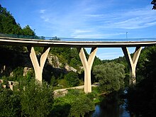
| Slunj Ž3256 to Gornje Primišlje, Kamenica Skradnička and D23. Ž3257 to Taborište and Obrovci. Ž3258 to Batnoga, Cetingrad and Pašin Potok. Ž3266 to Donji Furjan, and Cetingrad. | |
| - 141.6 m (465 ft) long, spanning Korana River.[7] | |
| Broćanac | |
| Oštarski Stanovi | |
| Rakovica Ž3269 to Grabovac Drežnički. | |
| Grabovac | |
| Irinovac | |
| Drežnik Grad | |
| Ličko Petrovo Selo | |
| Prijeboj Ž5201 to Plitvice Lakes National Park and Selište Drežničko (D42). | |
| Vranovača | |
| Korenica | |
| Gradina Korenička | |
| Bjelopolje Ž5169 to Donji Lapac (D218). | |
| Jošan | |
| Ž5164 to and . | |
| Ž5195 to Udbina. The road forms another intersection with the D1 road south of Udbina. | |
| The norther terminus of two-lane expressway (Udbina bypass). | |
| Udbina interchange | |
| The southern terminus of two-lane expressway (Udbina bypass). | |
| Ž5195 to Udbina. | |
| Bruvno | |
| Gračac | |
| Ž5203 to Srb and Dobroselo (D218). | |
| Otrić Ž6033 to . | |
| Ž6025 to , Ervenik, Kaštel Žegarski and Obrovac (D27). | |
| Ž6034 to Radljevac and Plavno. | |
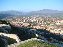
| Knin | |
| Ž6080 to Kninsko Polje. | |
| Kovačić Ž6057 to waterfall Krčić (river Krka). | |
| Ž6058 to Biskupija, Orlić, and . | |
| Kijevo Ž6083 to Cetina. | |
| Vrlika Ž6082 to Siverić (to the west) and to Bajagić, Otok and D220 (to the east). | |
| Podosoje | |
| Ž6101 to Otišić. | |
| Maljkovo | |
| Ž6102 to . | |
| Ž6103 to . | |
| Hrvace Ž6105 to . | |
| Karakašica Ž6117 to . Ž6118 to Čitluk and . | |
| Sinj | |
| Brnaze | |
| Ž6116 to and . | |
| Ž6120 to . | |
| Dicmo | |
| Ž6121 to . | |
| The northern terminus of the urban expressway through Split.[3] | |
| Podi interchange The interchange is accessed via a short connector. Ž6145 to Dugopolje. | |
| Klis Grlo interchange | |
| Bilice interchange The D8 within the city of Split is also executed as an urban expressway. The southern terminus of the urban expressway through Split[3] and the southern terminus of the road. | |
Maps[]
- ^ Overview map of the D1 (Map). OpenStreetMap. Retrieved October 13, 2013.
See also[]
- A1 motorway
- A2 motorway
- A3 motorway
Sources[]
- ^ a b Ministry of Sea, Transport and Infrastructure (Croatia) (May 10, 2013). "Odluka o razvrstavanju javnih cesta" [Decision on categorization of public roads]. Narodne novine (in Croatian) (066/2013).
- ^ a b c d "Regulation on motorway markings, chainage, interchange/exit/rest area numbers and names". Narodne novine (in Croatian). May 6, 2003.
- ^ a b c "PM Sanader opens a section of Solin-Klis-Sinj expressway". Ministry of Sea, Transport and Infrastructure (Croatia) (in Croatian). July 8, 2006.
- ^ "Public Roads Act". Narodne novine (in Croatian). December 14, 2004.
- ^ "Traffic counting on the roadways of Croatia in 2013 - digest" (PDF). Hrvatske ceste. May 2014. Archived from the original (PDF) on 2014-07-29. Retrieved 2014-07-19.
- ^ a b c d e f "Map of border crossings and customs office areas" (PDF). Customs Administration of the Republic of Croatia (in Croatian). March 6, 2008.
- ^ "Slunj bridges". Građevinar (in Croatian). January 15, 1999. Archived from the original on December 12, 2007.
External links[]
![]() Media related to Državna cesta 1 at Wikimedia Commons
Media related to Državna cesta 1 at Wikimedia Commons
- State roads in Croatia
- Transport in Karlovac County
- Krapina-Zagorje County
- Lika-Senj County
- Transport in Split-Dalmatia County
- Transport in Šibenik-Knin County
- Transport in Zadar County
- Zagreb County
- Buildings and structures in Krapina-Zagorje County