D45 road (Croatia)
 | |
|---|---|
 | |
| Route information | |
| Length | 43.6 km (27.1 mi) |
| Major junctions | |
| From | |
| To | |
| Location | |
| Counties | Bjelovar-Bilogora, Sisak-Moslavina |
| Major cities | Garešnica, Kutina |
| Highway system | |

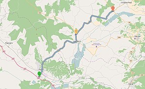
D45 connects the A3 motorway Kutina interchange to Kutina, Garešnica and the D5 state road.[1] The road forms two junctions to the D26 state road, one in Garešnica, where D26 branches off to Daruvar, and another 3 km (1.9 mi) further north, where the D26 branches off to Čazma and Vrbovec. Between those two junctions the D45 and D26 are concurrent. The northern terminus of the road is in Veliki Zdenci, at a junction to the D5 state road to Virovitica (to the north) and Daruvar and Pakrac (to the south).[maps 1] The road is 43.6 km (27.1 mi) long.[2]
The road, as well as all other state roads in Croatia, is managed and maintained by Hrvatske ceste, a state-owned company.[3]
Traffic volume[]
Traffic is regularly counted and reported by Hrvatske ceste, operator of the road.[4]
| D45 traffic volume | ||||
| Road | Counting site | AADT | ASDT | Notes |
| 2207 Veliki Zdenci | 1,340 | 1,563 | Adjacent to the Ž3136 junction. | |
| 2209 Hercegovac | 2,052 | 2,219 | Adjacent to the Ž3133 junction. | |
| 2115 Kapelica | 2,647 | 2,892 | Adjacent to the D26 junction. | |
Road junctions and populated areas[]
This article contains a bulleted list or table of intersections which should be presented in a properly formatted junction table. (November 2021) |
| D45 junctions/populated areas | |
| Type | Slip roads/Notes |
| Veliki Zdenci Ž3136 to Tomašica and Garešnica (D26). The northern terminus of the road. | |
| Hercegovac Ž3133 to Ladislav and Pavlovac (D28). Ž3135 to the Ž3136 county road. | |
| Palešnik | |
| Zdenčac | |
| Garešnički Brestovac | |
The D26 and D45 state roads are concurrent to the south. | |
| Garešnica The D26 and D45 state roads are concurrent to the north. Ž3165 to Dišnik. | |
| Kapelica | |
| Rogoža Ž3166 to Veliko Vukovje. | |
| Šartovac | |
| Ž3164 to Kutinska Slatina. | |
| Ž3163 to Selište. | |
| Kutina Ž3124 to Voloder and Bunjani (to the west) and to Novska (D47) (to the east). | |
The southern terminus of the road. | |
Maps[]
- ^ Overview map of the D45 (Map). OpenStreetMap. Retrieved August 25, 2014.
Sources[]
- ^ "Regulation on motorway markings, chainage, interchange/exit/rest area numbers and names". Narodne novine (in Croatian). April 24, 2003. Archived from the original on October 4, 2011. Retrieved August 10, 2010.
- ^ Ministry of Sea, Transport and Infrastructure (Croatia) (May 10, 2013). "Odluka o razvrstavanju javnih cesta" [Decision on categorization of public roads]. Narodne novine (in Croatian) (066/2013).
- ^ "Public Roads Act". Narodne novine (in Croatian). December 14, 2004.
- ^ "Traffic counting on the roadways of Croatia in 2013 - digest" (PDF). Hrvatske ceste. May 2014. Archived from the original (PDF) on 2014-07-29. Retrieved 2014-08-25.
- State roads in Croatia
- Bjelovar-Bilogora County
- Sisak-Moslavina County