D30 road (Croatia)
 | |
|---|---|
| Route information | |
| Length | 79.7 km (49.5 mi) |
| Major junctions | |
| From | |
| To | |
| Location | |
| Counties | Zagreb County, Sisak-Moslavina |
| Major cities | Velika Gorica, Petrinja, Hrvatska Kostajnica |
| Highway system | |
| |

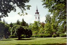
Velika Gorica, on the D30 road route
Petrinja, on the D30 road route
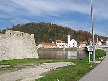
Hrvatska Kostajnica, at the southern terminus of the D30 road
D30 is a state road in central Croatia connecting Velika Gorica, Petrinja and Hrvatska Kostajnica[maps 1] to Croatian motorway network at the A3 motorway Kosnica interchange and to the City of Zagreb via .[1] The road is 79.7 km (49.5 mi) long.[2]
The road, as well as all other state roads in Croatia, is managed and maintained by Hrvatske ceste, state owned company.[3]
Traffic volume[]
Traffic is regularly counted and reported by Hrvatske ceste, operator of the road.[4] Sections of the road running through Velika Gorica and Petrinja are not covered by the traffic counting sites, but the section is assumed to carry a substantial volume of urban traffic in addition to the regular D30 traffic.
| D30 traffic volume | ||||
| Road | Counting site | AADT | ASDT | Notes |
| 2014 Velika Mlaka | 37,260 | 35,160 | Between the Ž3109 and D408 junctions. | |
| 2035 Velika Gorica northern bypass | 7,958 | 7,119 | Adjacent to the D408 junction. | |
| 2019 Lekenik | 8,469 | 8,547 | Adjacent to the Ž3230 junction. | |
| 2020 Žažina | 8,439 | 8,600 | Between the D36 and Ž3156 junctions. | |
| 3208 Petrinja - north | 4,718 | 5,306 | Between the Ž3242 and D37 junctions. | |
| 3205 Budičina | 2,034 | 2,583 | Adjacent to the Ž3201 junction. | |
| 3311 Hrvatska Kostajnica | 3,080 | 3,464 | Adjacent to the D224 junction. | |
Road junctions and populated areas[]
This article contains a bulleted list or table of intersections which should be presented in a properly formatted junction table. (November 2021) |
| D30 junctions/populated areas | |||||
| Type | Slip roads/Notes | ||||
| Kosnica interchange To Zagreb via . Both the D31 to the south of the interchange and Radnička Road to the north are double carriage roads The northern terminus of the road. | |||||
To Velika Gorica via Sisačka street. The southern terminus of the suburban double carriage road. | |||||
| Vukovina | |||||
| Buševec | |||||
| Ogulinec | |||||
| Peščenica Ž3151 to Brežane Lekeničke and . Ž3292 to Peščenica railway station. | |||||
| Lekenik | |||||
| Ž3230 to Poljana Lekenička | |||||
| Dužica Ž3157 to Greda. | |||||
The D30 and D36 roads are concurrent to the south of the junction. | |||||
| Ž3156 to Žažina | |||||
The D30 and D36 roads are concurrent to the north of the junction. | |||||
| Ž3156 to Mala Gorica | |||||
| Brest Pokupski Ž3242 to Vurot, Stara Drenčina and Staro Pračno. | |||||
The D30 and D37 roads are concurrent to the east of the junction. | |||||
| Petrinja The D30 and D37 roads are concurrent to the west of the junction. Ž3200 to D37 state road. | |||||
| Donja Budičina | |||||
| Ž3201 to Donja Mlinoga | |||||
| Moštanica | |||||
| Blinja Ž3208 to Mađari. | |||||
| Bijelnik | |||||
| Ž3240 to Gornja Mlinoga | |||||
| Ž3244 to Mala Gradusa and Drljača. | |||||
| Knezovljani | |||||
| Umetić | |||||
| Ž3241 to Mečenčani and Borojevići. | |||||
| Donji Kukuruzari | |||||
| Panjani | |||||
| Hrvatska Kostajnica | |||||
| Hrvatska Kostajnica border crossing to Bosnia and Herzegovina.[5] The road extends to Bosanska Kostajnica, Bosnia and Herzegovina. The southern terminus of the road. | |||||
1.000 mi = 1.609 km; 1.000 km = 0.621 mi
| |||||
Maps[]
- ^ Overview map of the D30 (Map). OpenStreetMap. Retrieved July 22, 2014.
Sources[]
- ^ "Regulation on motorway markings, chainage, interchange/exit/rest area numbers and names". Narodne novine (in Croatian). May 6, 2003.
- ^ Ministry of Sea, Transport and Infrastructure (Croatia) (July 18, 2014). "Odluka o razvrstavanju javnih cesta" [Decision on categorization of public roads]. Narodne novine (in Croatian) (094/2014). Archived from the original on 2016-03-04.
- ^ "Public Roads Act". Narodne novine (in Croatian). December 14, 2004.
- ^ "Traffic counting on the roadways of Croatia in 2013 - digest" (PDF). Hrvatske ceste. May 2014. Archived from the original (PDF) on 2014-07-29. Retrieved 2014-07-22.
- ^ "Map of border crossings and customs office areas" (PDF). Customs Administration of the Republic of Croatia (in Croatian). March 6, 2008.
Categories:
- State roads in Croatia
- Sisak-Moslavina County
- Zagreb County
- Roads in Zagreb